Rural power grid resources WebGIS technology research based on ArcIMSBAO Qing—peng
2016-07-12 09:31:59ZHANGXuSUZhong-bi
科技視界 2016年6期
ZHANG+Xu SU+Zhong-bin ZHU+Jia-mei
【Abstract】WebGIS is a tendency of current geographical information system. ArclMS is an excellent platform to construct WebGIS. This paper introduces the architecture,features and advantages of ArcIMS,which also builds a rural power resources information system based on ArcIMS.This system is a security assurance of reactive power optimization of distribution network,is an effective method of economic operation and is one of important measures to improve the voltage quality of distribution network. Applying ArcSDE to establish spatial database and transform the format of spatial data are key to realizing the system.
【Key words】Geographic information system; Agricultural power grid resources; WebGIS; ArcIMS; ArcSDE
0 Introduction
With the development of county-level power users and increase of transmission network, how to better the complicated structure, transmission network management covers a wide area, has become an important issue facing management layer and a base of production department(Bi H L. 2008). A paper map based the traditional management mode, has been unable to meet the production management and improve the power supply quality of service requirements, required to establish an enterprise production management information system.
Commercial AcrMIS platform is proposed and implemented a novel WebGIS system and easy expansion of power distribution network based on information management.This system has all the Gis functions, including zoom,eagle eye,query,add, modify,delete,can manage a mass ofspatial data and attribute data, and through the Internet for users to browse and call, and has higher practicability.
1 The choice of GIS platform
GIS international application got very high attention,the application of growing surface. GIS international application should pay attention to two aspects,one is for large projects,two are for the public.In the developed countries of North America and Western Europe,GIS applications have formed a certain scale,however,the application depth and did not achieve the desiredlevel,most of the GIS also just stay in the drawing,the analysis and decision support functionhas not been due to play(Yuan J et al. 2008).
ArcIMS makes Internet GIS also took a big step forward.The typical feature of ArcIMS is the ability to elements of data stream.So each client of the system transmission of vector data elements in between Java sites.The system through the browser object model interface(ObjectModel API) custom viewer functions,and through the HTML and JavaScript by calling appletscustom Java browser.
ArcSDE is a spatial data engine ESRI issued by the company, is the connection between ArcIMS and database “middleware”, which is mainly used for efficient storage,indexing and accessing the stored vector, in commercial DBMS grid, metadata and other spatial data(Yuan J J et al., 2008). ArcSDE, the data path, is the spatial data engine of ArcGIS, which is stored and managed in the relational database management system(RDBMS). From the perspective of spatial data management, ArcSDE is a continuous spatial data model, with the help of the spatial data model, it can be realized with RDBMS management spatial database. After the integration of spatial data in ArcSDE, RDBMS can provide the database services for efficient operation of spatial and non spatial data. ArcSDE uses a client / server architecture, so many users can concurrently access and operate the same data(Zhao Q and Zhao J T,2006). ArcSDE also provides application interfaces, software developers can integrate spatial data retrieval and analysis functions into their own applications(Zhou X, 2007).
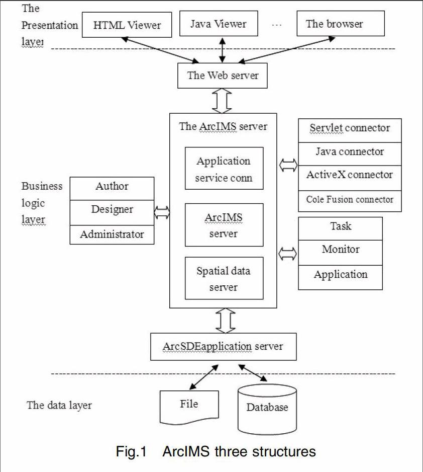
ArclMS is a distributed system is composed of client and server components parts.The clientthrough the Internet or Intranet server to send a request to the AcrIMS information,ArcIMS server processes the request,and returns the result to the client browser.ArcIMS is the threetier distributed structure based on B/S,as shown in figure 1.
Fig.1 ArcIMS three structures
ArcIMS has the following characteristics:
(1)the rapid and flexible development two times. The system structure and package AcrIMS good, we can use less time to develop suitable for your project needs a WebGIS platform. That would save a lot of manpower and material resources. In view of application situation, many applications of GIS units do not have the time and energy is not necessary to start from the bottom of GIS.
(2)two times development modes. The development of its client supports bothsimple customization of JavaScript, also support the Java plug-in manner, andsupport the development of the ActiveX APS development mode and based on.Net.
(3)security. ArcIMS of the user using the rights management, separate themanagement of GIS Services Publication and application of GIS service authority, greatly enhance the security of the data.
(4)cross platform. AcrIMS of the grid resource management interface based on Java development, can run on other platforms besides the windows such as UNIX, 1inux etc.. If you change the user platform, also can use less time to complete the transfer platform, without the need to do.
(5)and the integration of ArcGIS height. Will ArcGIS as the back-end data processing, can make full use of ArcGIS powerful spatial analysis and mappingfunction.
2 Software and hardware configuration of the system operation
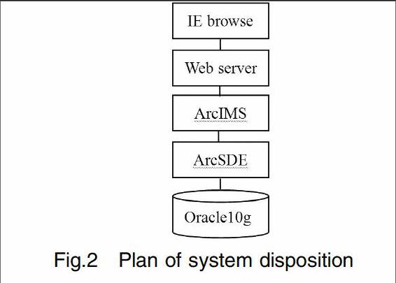
The system structure of distribution system for Browse/Server mode, integratedmanagement using ArcSDE spatial data engine implementation related information of space, strictly follow the data layer/logic layer/ presentation layerand the three layer system structure, as shown in figure 2.
Fig.2 Plan of system disposition
The hardware environment used in the system: using a Pentium 4 CPU, 2.8Gdesktop as a server, used to provide resource data grid service installationfollowing the agricultural release software.
The software environment used in the system: the system platform for the Microsoft Windows XP of the Web server for Tomcat 6 JDK Java SE6.0 for the ArcIMS9.0 ArcInfo9 ArcSDE10 Apache2 the database for Oracle10g and Dreamweaver8, Photoshop software.
General steps of exploitation of resource system of rural power grid
System ArcIMS graphics data organization, transmission and display, using HTML language user interface, based on Tomcat6.0, the construction of the server application with ASP technology, through the ArcSDE server and ODBC Oracle database to request and obtain data, and promptly returned to the user.The system adopts the three layer system structure of B/S is a user based on the presentation layer, application logic layer and data storage layer.
3 A system for making process
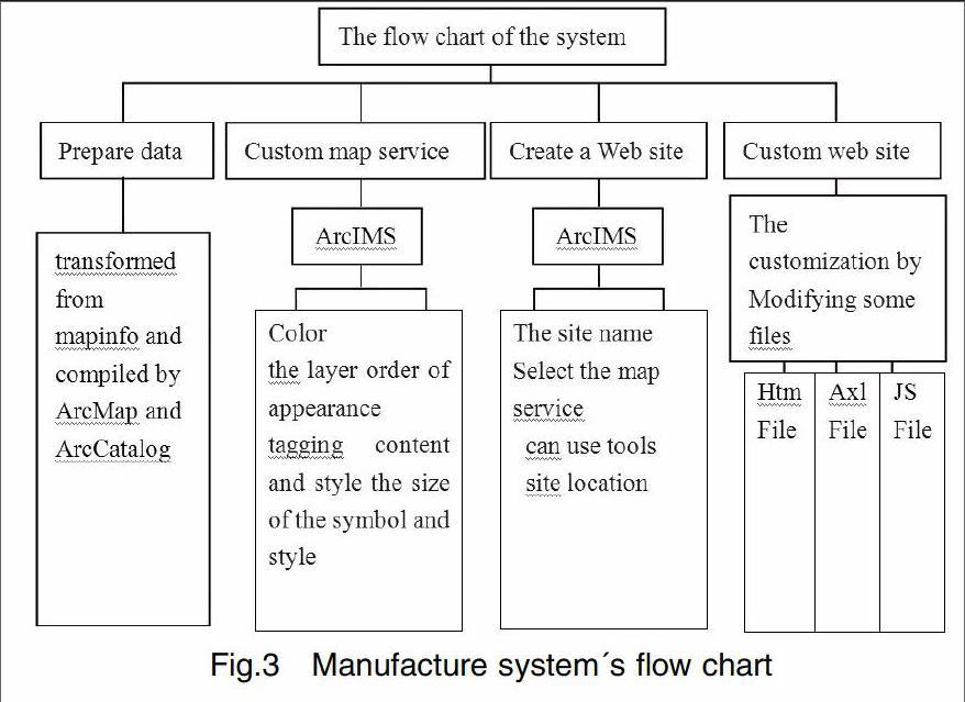
Production system process as shown in Figure 3.
Fig.3 Manufacture system's flow chart
3.1 Prepare data
The system used shape format data was through the MapInfo Professional 6 this tool software will mapinfo format data transformation from Binxian got to come.Through combining ArcCatalog with ArcSDE converted the success of shapeformat data stored in Oracle database, and added or removed the attribute datathrough ArcMap.
3.2 Custom map service
After the data was ready to create a map service. Custom map service process was actually using ArcIMS Author production of map service file AXL(Arc eXtensiblemarkup Language) file, and then publish map service through the Administrator in the middleware, create and register.
First of all, started Author, used the Add Layers tool button to load the SDE toolbarin layers, each layer was arranged for the property, mainly including: the coloradjustment layer and seted the layer of the emergence of the order of the size andstyle of set point line surface symbol seted the content and style of annotation.Finally saved as AXL map configuration file. Record format of the file was based on the XML (eXtensible markup Language), it records the data to be published, the data storage location and how was this data display. AXL files done not store the actual data layer, but only storeed the data reference information, can be independent of ArcIMS Author environment using the text editor to edit.
Map configuration files were created, need to use the Administrator AXL filecreated and activated map service according to the.
Then, started Administrator, clicked the Service menu selected New Name column inputsmap service name in the pop-up dialog box, enter the map configuration fileaddress in the Map File column, and selected the ImageServer1 virtual server in the Virtual Server column, determine and saved the setting was completed service creation.
3.3 Create a Web site
According to the ArcIMS Author to define the data, after the ArcIMS created Administrator map service, it can be released by ArcIMS website designDesigner.
Started ArcIMS Designer according to the guide for customized according to the following steps:
(1)Created a Web Site panel: site name and Webpage Title name.
(2)the Service panel: used to select the display on the client's map service.
(3)Java or HTML Viewer panel: used to select the client browser template, Java browser can transfer vector elements, allows the client to drawing editor; HTML browser can only transfer map image, so we choose Java Viewer this one.
(4)Web Site Template panel: selection can use image map service and map element service Java Custom template.
(5)the Visible Layer panel: select all layers visible layer.
(6)the Toolbar Functions panel: used to define integrated into the ArcIMSbrowser toolbar button, can according to different users to configure button.
(7)the Identify Results panel: used to set the browser, capable of performing the Identify attribute, range query operation layer and attribute field to see, thesystem queries on all layers can be attribute information.
(8)Web Site Location panel: sets the current site location, set to the defaultinstallation of ArcIMS process in the c:\ArcIMS\Website folder. Click createCreate Web Site complete Web site.
Thus, a simple Web site has been generated, in the whole process can alwaysclick Back to return, re selection.
3.4 Custom web site
Create a simple interface functional ArcIMS site through the above a few steps,but not enough for our rural power resource management demand at the same time the display interface characters are English, which we need to manuallychange the relevant documents, in order to achieve the purpose of custom tailored Web website.
(1)framework customization: modify the viewer.htm file to change the web page layout.
(2)the toolbar customization: modify the toolbar.htm file to generate differentlayout toolbar and use their own definition of icon.
(3)the most simple custom ArcIMS: modify the ArcIMSparam.js file, change the service connection variables for VARimsURL='http://219.217. 212.166/servlet/com.esri.esrimap.Esrimap?ServiceName=bx'; ServiceName=bx'varimsOVURL='http://219.217.212.166/servlet/com.esri.esrimap.Esrimap?;
(4)finished the Web website: all the HTML files within a site of charset=ISO-8859-1 instead of charset=gb2312. At the same time finished aimsResource.js file.
4 The main function of the system
(1) the basic functions: the map to enlarge, narrow, map, translation, ranging,set;
(2)selection function: frame selection, multiple choice, clear;
(3)query function: condition query, attribute query, search;
(4)auxiliary function: switch, legend and layers of Hawkeye, print;
5 Conclusion
Rural power grid had features of having long radius, needing more spatial information to manage. Rural power companies were in the stage of function transformation and service level improvement. Researching and developing the rural power network system which was based on WebGIS, realizing the publishment of rural power resources on the network, satifying the needed of power enterprise and rural electricity users to query power resource information had high practical value. Establishing distribution network of overhead lines and cable lines device information database was the core of this system. Combined with the advantages of WebGIS technology to build distribution network overhead line and cable lines device information library, so that users can search details about related equipment more easily and quickly. However, there were many shortcomings of this system: interface frame layout color collocation and each layer elements were not made by professional art designer , and functions just involved some basic GIS functions, in order to make a complete set of WebGIS products requires artists to design the beauty of pages and develop with the combination of OA (Office Automation) system and so on.
【References】
[1]Bi H L. 2008.The management information system of school laboratory based on ArcIMS[J]. Software guides,24:23-33.
[2]Chen J H, Cao J. 2007.GIS fiber-optic telecommunications cyber sourcemanagement system design of[J]. Telecommunication engineering technology and standardization, 12: 34-44.
[3]Dmbion, Inc. 2008. ESRI the company's Web site, http://www.esri.com[Z].
[4]Ives, Inc. 2009. Mapinfo the company's Web site, http://www.mapinfo.com[Z].
[5]WU P, Cheng W M. 2001.Digital earth monitoring forests of the world[J]. Journal of remote sensing, 1: 17-23.
[6]Yuan J J, Tang B, Zhu Y B. 2008.Research and building of network of mineral resources based on ArcIMS and GIS Ajax[J]. Resources science and technology management of land, 12: 19-23.
[7]Zhao Q, Zhao J T. 2006.Distribution network WebGIS technology based on ArcIMS[J]. Journal of North China Electric Power University, 5: 17-20.
[8]Zhou X. 2007.Development Foshan city map website with ArcIMS[R]. Bulletin of Surveying and mapping, 8: 19-20.
[責(zé)任編輯:楊玉潔]