以分級分類的空間管控為抓手的大遺址保護規劃基本策略
——良渚遺址保護規劃簡介
2019-11-26 03:41:48規劃設計陳同濱
世界建筑 2019年11期
關鍵詞:規劃
規劃設計:陳同濱
“良渚遺址”(距今5300 ~4300 年)是中國長江下游地區極為重要的新石器時期考古遺址。1996年由國務院公布為第三批全國重點文物保護單位;2019 年以“良渚古城遺址”申報世界遺產成功,成為世界矚目的偉大遺產,被認為“改寫了人類歷史”。回顧該遺址的保護歷程,從1994 年列入《預備名單》到2019 年世界遺產大會通過,在25 年的時間里,良渚遺址經歷了一個堪稱“艱巨而偉大”的保護歷程。其中僅它的保護規劃編制與實施過程,在中國的世界文化遺產和大遺址保護方面就頗有突出的代表性。
本所從2000 年開始受理良渚項目,在近20 年的時間中,一共主持編制或指導編制過3 套規劃,用于指導全國重點文物保護單位“良渚遺址”的保護管理及其“良渚古城遺址”的申遺過程:其一是主持編制了啟動于2000 年的《良渚遺址保護總體規劃2008-2025》(以下簡稱《總規》);其二是主持編制了啟動于2012 年的《良渚古城遺址保護管理規劃2017-2050》(以下簡稱《管規》);其三是指導編制了遺產區的一系列專項規劃,包括《土地利用專項規劃》《村落控制性詳細規劃》《道路交通專項規劃》《基礎設施專項規劃》《水系保護專項規劃》等。這3 套規劃形成了一個有機的關聯序列,分別規劃了良渚遺址在總規、控規和詳規3 個層面的保護管理工作目標,完整體現了中國大遺址保護規劃的主要技能——以分級分類的空間管控為抓手的大遺址保護規劃基本策略。
1 《良渚遺址保護總體規劃2008-2025》
《總規》的規劃對象是全國重點文物保護單位“良渚遺址”,規劃范圍111.29km2。在空間規劃方面采用了下列3 個步驟:
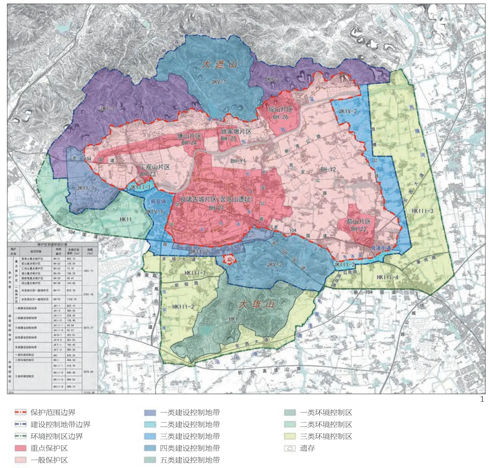
1 良渚遺址保護總體規劃保護區劃圖
(1)設立并劃定保護范圍、建控地帶和環境控制區3 個控制層級,區劃范圍分別對應于遺址本體的分布區、遺址環境要素與可能分布有遺存的分布區,以及基本完整的視線空間范圍。邊界的劃定除了完整包含相關要素之外,主要考慮了地形地貌的基本輪廓,并進一步結合歷史水系現狀河流與道路等現狀地標劃定。這3 個層級的保護區劃設定,以及制定相應的建設控制與土地利用管理規定,基本奠定了完整保護遺址及其環境的空間管控格局。
(2)進一步針對遺產地高速發展的城鎮化、工業化進程,結合區劃設定明確提出保護規劃策略:保護范圍內遏制城鎮化進程、保護范圍外強化城鎮化進程。前者包含了削減建設用地、控制并削減居住人口、搬遷廠礦企業、限止過境交通、保持農業用地、保護生態環境等規劃措施與要求,后者包含了安置搬遷居民、擴大城鎮建設用地、設立工業新區、提升基礎設施、加強城市道路系統建設、調整經濟結構等規劃措施與要求。這一策略憑借不同空間的功能布局形成“堵”與“導”的組合,對遺產地的保護與發展進行統籌,兼顧協調了不同利益方的訴求。
(3)針對規劃目標實施的可操作性和有效性,在3 級區劃中進一步開展分級分類的地塊劃定——在保護范圍內劃出重點保護區和一般保護區、在建控地帶依據不同強度的建設控制力度劃出4 類區塊、在環境控制區按照不同要求的環境協調程度劃出2類區塊。這一區劃手法不僅為區分管控力度與管理內容設立了界面,也為實施規劃措施的分期分批提供了依據。
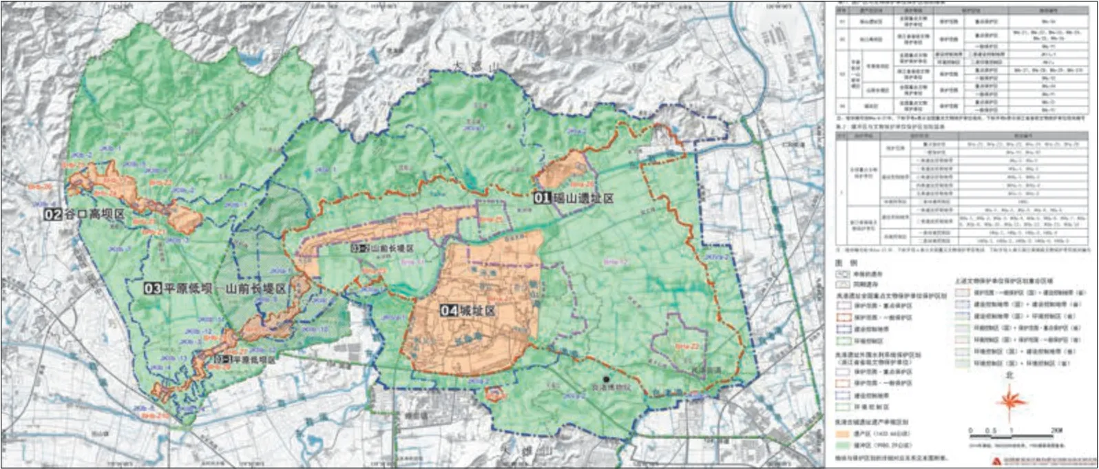
2 《良渚古城遺址保護管理規劃2017-2050》
《管規》的規劃對象是世界遺產申報項目“良渚古城遺址”,規劃范圍114.14km2,規劃范圍包含了考古新發現的外圍水利系統。在空間規劃方面主要采用了下列3 個步驟:
(1)依照申報文本的價值要素,劃國保單位“良渚遺址”的大部分重點保護區與省保單位“外圍水利系統”的保護范圍為世界遺產的申報區,即遺產區,保護管理規定按照文物保護單位重點保護區規劃要求執行。
(2)將國保單位“良渚遺址”其余的保護范圍與建控地帶與省保單位“外圍水利系統”的建控地帶整合為世界遺產的緩沖區,其中各個區塊的管理規定按照文物保護單位保護規劃的相應規定分別執行。
(3)繼續貫徹落實《總規》的保護規劃策略“保護范圍內遏制城鎮化進程、保護范圍外強化城鎮化進程”,在《管規》中細化為遺產申報區和緩沖區的具體措施,指導整個保護管理工作的行動計劃。
(4)結合申遺目標,部分調整《總規》分期計劃:將申報區,即遺產區的主要規劃措施列為近期和中期重點實施項目;將緩沖區的規劃措施實施期限往后推。
由此,不僅世界遺產的保護區劃與文物保護單位的保護區劃達成有效銜接,操作條理清晰;遺產申報的規劃措施分期與國保單位的規劃措施分期也在空間界定的基礎上獲得可操作的調整與銜接。
3 呈系列的專項詳細規劃
這套專項規劃包括《土地利用專項規劃》《村落控制性詳細規劃》《道路交通專項規劃》《基礎設施專項規劃》《水系保護專項規劃》等。作為對《總規》的保護規劃策略“保護范圍內遏制城鎮化進程、保護范圍外強化城鎮化進程”的實質性貫徹落實,系列專項規劃依據《管規》提出的各項規劃具體要求進行詳細編制,落實到各類項目的可實施深度,最終為規劃執行者提供了操作手冊與任務書。同時,系列專項規劃與《管規》在編制過程中也進行了互動的密切銜接,確保了理念的貫徹與措施的可操作。
尤為值得一提的是,在上述3 級規劃的編制過程中,在落實以分級分類的空間管控為抓手的大遺址保護規劃基本策略時,這類大型遺址的規劃編制必須具備足夠的深度,要與遺產所在地的規劃部門形成密切的合作,否則往往流于“概念規劃”深度,無法實施。良渚遺址的3 套規劃在編制與銜接過程中,明顯得益于杭州市規劃院的鼎力支持與投入:與良渚遺址的《總規》與《管規》直接關聯的《杭州城市總體規劃》、《良渚古城外圍水利系統保護區劃》以及全套良渚遺址保護系列專項規劃,全部由杭州市規劃院承擔,多個團隊在院領導與總工們的積極支持與直接組織下積極投入,并在工作過程中都展現出優良的敬業精神與忘我拼搏的工作態度,為整個良渚遺址的保護管理和申遺工作做出了不可或缺的顯著貢獻。□
Archaeological Ruins of Liangzhu (5300-yearold to 4300-year-old) is an important neolithic archaeological site in the lower reaches of the Yangtze River. In 25 years from its inclusion in the Tentative Listin 1994 to its inscription in World Heritage List in 2019, Archaeological Ruins of Liangzhu has undergone a "arduous and great" conservation process. In terms of the compilation and implementation process of its conservation plan, it is quite representative in the conservation of world cultural heritage and major site in China.
2 良渚古城遺址保護管理規劃遺產區劃銜接圖
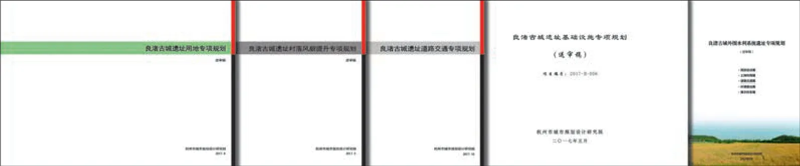
3 良渚古城遺址保護規劃專項規劃系列文件
The Master Conservation Plan for the Archaeological Ruins of Liangzhu (Liangzhu Ruins in short) formulated regulations on the construction control and management of 111km2, including the urban restricted construction area of 42km2. By containing the urbanisation process within the conservation scope of Liangzhu Ruins, the master plan of the conservation of Liangzhu Ruins realised a win-win relationship that benefits cocal residents from the conservation of the heritage, and made the heritage safer after eliminating the construction activities. In particular, deductions should be made within the scope of conservation, which includes population reduction, the control of construction activities, prohibition of industrial development, elimination or reduction of transit traffic, etc; while additions should be made outside of the conservation area, such as to develop new industrial district and increase the urban construction land in land use planning, to boost the construction of traffic system and supporting facilities of intercity or the outskirt of the site area, including "three supplies and one leveling" and so on. It should help form obvious environmental advantages, attract interests, and create conditions for residents within the scope of conservation to make voluntary decision and seek better living atmosphere and development conditions, instead of their house steads being forcibly expropriated.
To achieve the effective conservation of the heritage, the fundamental approach of the master plan is to put forward the space control strategies of the site area. This is embodied in the set of level 3 conservation division (the scope of conservation, the construction control area, and the environment control area). The master plan also formulated a series of measures for conservation demand, and put forward a series of urban and rural development suggestions for development needs, according to the principle of "within the scope containing the urbanisation, and outside the scope accelerating the urbanisation". In addition to the space control, it further promoted the effective connection between heritage conservation planning and urban development planning, and realised the transfer of land use functions and the reduction of transit traffic load by combining with the urban planning of Hangzhou City. Moreover, in the planning process of the conservation of Liangzhu site, the city's decision makers and administrators played their due role, published the master plan of conservation, and proposed land economic policies, which contributes to the first batch of relocation process of the planning.□ (Text by PANG Lingbo)
猜你喜歡
房地產導刊(2021年6期)2021-07-22 09:12:46
中國石油石化(2021年9期)2021-07-17 09:24:00
中國農民合作社(2020年12期)2020-12-18 09:09:58
公民與法治(2020年11期)2020-07-25 02:02:06
河南水利年鑒(2020年0期)2020-06-09 05:43:30
領導決策信息(2018年50期)2018-02-22 06:17:16
商周刊(2017年5期)2017-08-22 03:35:26
制造技術與機床(2017年3期)2017-06-23 08:11:34
中國衛生(2016年2期)2016-11-12 13:22:16
華東科技(2016年10期)2016-11-11 06:17:41
