基于直升機巡檢系統數據的處理的研究與應用
2020-11-13 03:38:57姜誠張建剛李庭堅張福高豐
微型電腦應用
2020年10期
姜誠 張建剛 李庭堅 張福 高豐
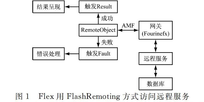
摘要:為提升復雜背景下直升機巡檢系統巡檢質量,和研究直升機巡檢系統的數據處理。通過FlashRemoting應用網關獲取數據請求指令完成數據的采集,通過AMF協議實現數據遠程傳輸,通過ArcGISAPIforFlex、Flexframework設計表現層。依照組別功能要求將表現層做分工處理,建立框架模型。服務層由GIS服務器和Web服務器構成,ArcGISServer用于定位系統可為用戶提供路線定位服務。通過httpservice類或webservice調用客戶端發布的服務,通過API訪問ArcGISServer服務端的各類數據,將地圖切片技術與GIS服務器動態地圖渲染技術進行結合,發布地圖服務。采用ModifiedHT算法進行直線提取,調用RemoteDataConnect設置參數查詢作業方案獲取巡航圖,完成巡檢系統數據的處理。經實驗驗證,該算法對復雜背景下航空圖像的電力線完整提取是十分有效的,可在直升機巡線系統中得到成功應用,滿足巡檢質量要求。
關鍵詞:線路巡檢;動態數據;視頻選幀;地理信息;智慧交通;統計分析
中圖分類號:TM726
文獻標志碼:A
ResearchandApplicationofDataProcessingBasedonHelicopterPatrolInspectionSystem
JIANGCheng1,ZHANGJiangang2,LITingjian3,ZHANGFu4,GAOFeng5
(1.MaintenanceandTestCenter,EHVPowerTransmissionCompany,ChinaSouthernPowerGrid,
Guangzhou510663,China;2.BeijingYupontElectricPowerTechnologyCo.Ltd.,Beijing100029,China)
Abstract:Inordertoimprovetheinspectionqualityofhelicopterpatrolsystemundercomplexbackground,theresearchofdataprocessingbasedonhelicopterpatrolsystemisproposed.DatarequestinstructionisacquiredthroughFlashRemotingapplicationgatewaytocompletedataacquisition,dataremotetransmissionisrealizedthroughAMFprotocol,andthepresentationlayerisdesignedbyArcGISAPIforFlexandFlexframework.Accordingtothefunctionalrequirementsofthegroup,theperformancelayerisdividedintodifferentpartsandaframeworkmodelisestablished.TheservicelayeriscomposedofaGISserverandaWebserver.ArcGISServerisusedforlocationsystemtoprovideroutelocationserviceforusers.Theservicepublishedbyclientisinvokedbyhttpserviceclassorwebservice.ThedataofArcGISServerisaccessedbyAPI.ThemapslicingtechnologyiscombinedwithdynamicmaprenderingtechnologyofGISservertopublishmapservice.ModifiedHTalgorithmisusedtoextractstraightlines,andremotedataconnectisusedtosetparameterstoquerytheoperationplantoobtainthecruisemapandcompletethedataprocessingofthecruiseinspectionsystem.Theexperimentalresultsshowthatthealgorithmisveryeffectiveforthecompleteextractionofpowerlinesfromaerialimagesincomplexbackground,andcanbesuccessfullyappliedinhelicopterpatrolsystemtomeetthequalityrequirementsofpatrolinspection.
Keywords:lineinspection;dynamicdata;videoframeselection;geographicinformation;intelligenttransportation;statisticalanalysis
0引言
直升機巡檢作業是我國電網公司推行線路的重要巡檢業務模式,綜合紅外、紫外等先進、高效的手段和應用模式,具有故障及時發現、工作效率高、人工無法替代等優點。可以減輕線路運檢班組的工作量,提高巡視的質量,降低線路運檢成本、作業風險和勞動強度,不斷提升線路運檢管理水平[1]。伴隨長距離輸電線路、大功率、特高壓的出現并投入使用,輸電線路變得越來越復雜,且資源越來越緊張。在城市發展需求下,輸電線路不允許在城市上空交錯紛亂排布,所以輸電線離城市主要交通要道愈加愈遠,一定程度上,對其日常的維護和維修也帶來一定的困難。……
登錄APP查看全文
猜你喜歡
工業設計(2022年8期)2022-09-09 07:43:20
軍民兩用技術與產品(2021年10期)2021-03-16 06:05:30
北京測繪(2020年12期)2020-12-29 01:33:58
今日農業(2019年12期)2019-08-15 00:56:32
今日農業(2019年10期)2019-01-04 04:28:15
今日農業(2019年16期)2019-01-03 11:39:20
家庭影院技術(2017年9期)2017-09-26 03:41:45
商周刊(2017年9期)2017-08-22 02:57:56