白堊紀以來東亞地貌演化與構造驅動: 來自沉積盆地與構造變形的記錄
2022-07-08 07:11:48田云濤秦詠輝張貴洪劉一珉潘黎黎顏照坤張增杰孫習林張培震
大地構造與成礦學 2022年3期
田云濤, 秦詠輝, 胡 杰, 張貴洪, 劉一珉, 潘黎黎,顏照坤, 張增杰, 孫習林, 張培震
白堊紀以來東亞地貌演化與構造驅動: 來自沉積盆地與構造變形的記錄
田云濤1, 2, 秦詠輝1, 胡 杰3, 張貴洪1, 劉一珉1, 潘黎黎1,顏照坤4, 張增杰1, 孫習林1, 張培震1, 2
(1. 中山大學 地球科學與工程學院, 廣東省地球動力作用與地質災害重點實驗室, 廣東 珠海 519082; 2. 南方海洋科學與工程廣東省實驗室(珠海), 廣東 珠海 519082; 3. 成都理工大學, 油氣藏地質及開發工程國家重點實驗室, 四川 成都 610059; 4. 東華理工大學, 核資源與環境國家重點實驗室, 江西 南昌 330013)
白堊紀以來, 東亞大陸構造的演變受東緣太平洋板塊西向俯沖及南海打開與西緣新特提斯洋閉合及隨后印度?歐亞板塊碰撞的雙重控制, 東亞大陸地形經歷了“蹺蹺板”式的演變: 白堊紀?早新生代地形東高西低, 與現今東傾地形相反; 晚漸新世以來東傾的一級地貌格局逐漸形成。為了進一步完善該模型, 本文報道了西江中?上游流域內玉林、十萬大山、南寧和百色盆地白堊紀?新生代古流向研究結果, 并綜合了珠江口盆地碎屑物源和青藏高原東南緣構造、古高程與水系演化研究進展, 獲得以下認識: ①白堊紀, 西江中?上游地區盆地物源主要源自盆地東側(可能是云開大山), 反映了東側地形相對較高, 與“蹺蹺板”模式所指出的中生代東高西低的地形一致。②古近紀, 珠江口盆地沉積物主要源自沿海花崗巖體, 西江中?上游玉林與十萬大山盆地物源仍然主要源自東側, 指示西江水系尚未貫通, 東部沿海高地形仍然存在; 結合該時期南寧和百色盆地物源來自東西兩側, 青藏高原東南緣強烈壓扭性變形和古高程研究所指示的地表抬升, 認為古近紀東亞地形應是兩側高、中部低的“V”字型樣式。③晚漸新世以來, 珠江口盆地物源信號逐漸與現代珠江一致; 在南寧盆地發現的新近紀河流相砂礫巖所指示的古流向與現今河流基本一致。這些證據說明珠江水系在晚漸新世以來逐漸形成, 反映了沿海地區地形已被夷平。隨著青藏高原東南緣的持續抬升, 現今西高東低的東亞地形逐漸成型。我們發現東亞地形“蹺蹺板”式的演變過程中, 在古近紀經歷了“V”字型的過渡狀態, 為進一步刻畫東亞地形演變歷史提供了新證據。
東亞; 青藏高原; 構造地貌; 沉積盆地; 古水系演化; 古地形重建
0 引 言
現代東亞地貌西高東低: 西部為高聳的青藏高原, 東部為丘陵與平原, 東緣為邊緣海盆地, 這一格局主要受控于板塊邊界的構造作用, 包括西部晚中生代?新生代新特提斯洋的消亡、隨后印度?歐亞板塊間的陸陸碰撞及東部太平洋板塊的俯沖(Yin and Harrison, 2000; 舒良樹和王德滋, 2006; Wang et al., 2013; Ye et al., 2018)。
伴隨著中?新生代東亞周緣動態、活躍的構造作用, 東亞的地形也經歷了多次重大轉變。中?新生代地形“蹺蹺板”式的演化模型被廣為接受, 該模型認為, 與現今東傾地形相反, 中生代和古近紀東亞地形呈現出東部發育沿海山脈, 而西部地勢較低的格局(陳丕基, 1979, 1997; 汪品先, 1998, 2005), 其地形發育主要受控于當時太平洋板塊向西俯沖, 東亞東緣為安第斯型活動大陸邊緣, 火山島弧位于現今南海北部洋陸過渡帶的位置(Xu et al., 2017; Cui et al., 2021)。隨著新近紀青藏高原的抬升和東亞邊緣海的拉開, 這一西傾的地形發生倒轉, 最終形成現今西高東低的特征(陳丕基, 1979, 1997; 汪品先, 1998, 2005)。該地形演化模型的重要證據是: 新近紀之前東亞缺乏大型的東流水系(如黃河和長江)(李吉均等, 1996; 汪品先, 1998, 2005); 以及晚中生代?古近紀東亞陸緣沿海山脈的屏障作用和熱效應, 使同時期華南內陸處于干旱?半干旱氣候并廣泛發育沙漠?鹽湖相沉積(陳丕基, 1979, 1997)。
對東亞地形演變的探究, 可具體歸結至對沿海山脈是否存在和其時限, 以及青藏高原抬升歷史的研究。關于沿海山脈, 其范圍大致位于南海北部洋陸過渡帶至沿海地區(圖1a), 因此內陸地區白堊紀?新生代沉積盆地的水系演化或可為探究沿海山脈的范圍與演化提供依據。近年來國內外學者通過古水系、古高程、沉積盆地、構造分析和地表剝蝕等研究, 在珠江口盆地物源演變、珠江水系演化、云貴高原構造與古高程重建等領域取得了新的進展。本文通過對前人工作的整理與歸納, 并結合本次對西江中?上游盆地水系演化方面的研究(圖1b), 試圖進一步完善對東亞地形演化的認識。
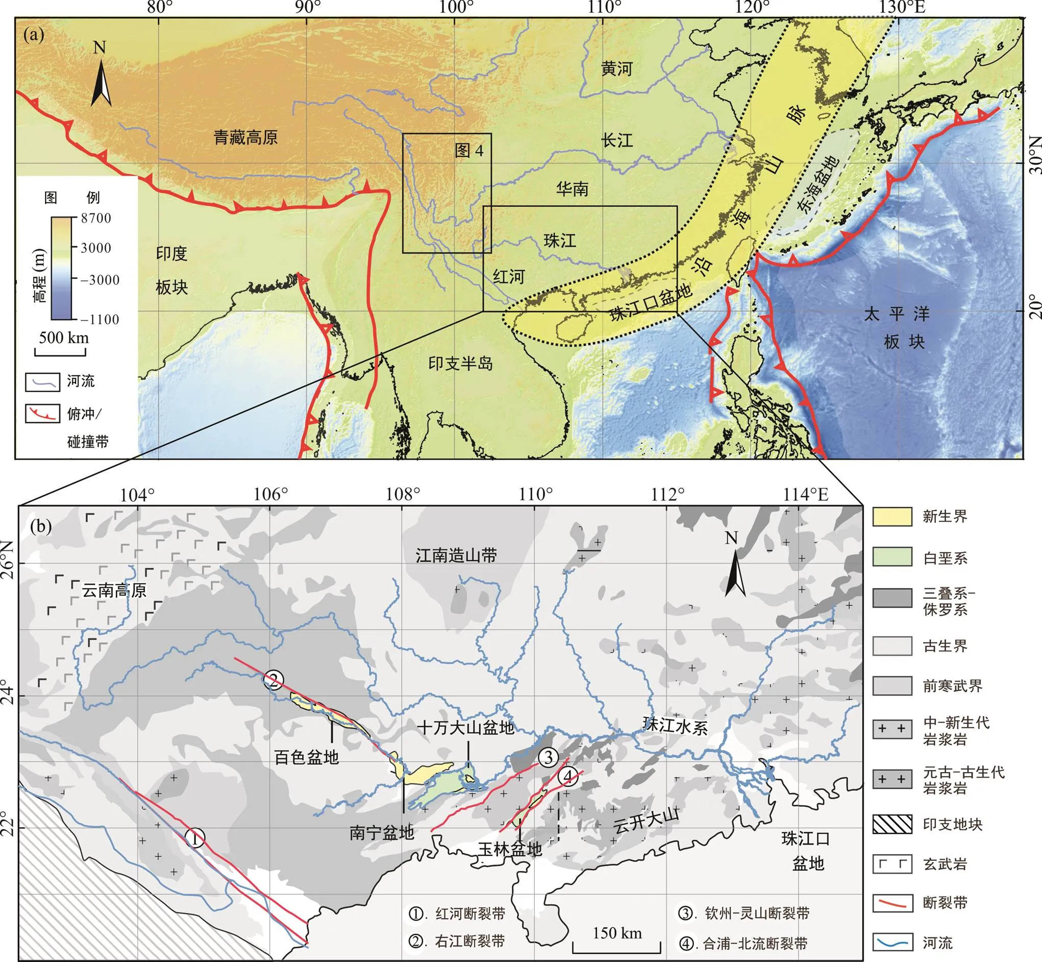
圖a虛線范圍內為白堊紀?早新生代東亞東部沿海山脈可能的分布范圍。
1 沿海山脈的分布與時限
1.1 珠江口盆地物源演變及古地形意義
本文總結了珠江口盆地鉆孔和珠江水系的碎屑鋯石數據(Shao et al., 2016, 2017; Xu et al., 2016b; Zhong et al., 2017; Cao et al., 2018; Wang et al., 2019), 并繪制了始新統以來的碎屑鋯石年齡譜綜合圖。結果顯示, 始新統碎屑鋯石年齡譜存在一個~115 Ma的主峰; 下漸新統的年齡譜主峰為~150 Ma, 次峰為~450 Ma, 另有少量~1000 Ma、~1800 Ma、~2500 Ma的鋯石年齡; 上漸新統年齡譜與下漸新統特征類似, 但是~1000 Ma、~1800 Ma、~2500 Ma的鋯石年齡比例有一定程度增加, 但仍為次峰; 下、中中新統與現代珠江的沉積物具有類似的碎屑鋯石年齡分布特征, 主要包括~145 Ma、~450 Ma、~1000 Ma、~1800 Ma、~2500 Ma的主峰(圖2)。碎屑鋯石年齡譜揭示漸新世以來2500~1000 Ma碎屑鋯石逐漸增多。結合珠江水系基巖特征: 沿海地區主要為中生代的花崗巖基, 向西為加里東期中?高級變質的云開大山, 再往西為揚子地塊; 推測珠江口盆地始新世?中新世沉積物碎屑鋯石年齡譜的變化, 反映了珠江水系逐漸向西拓展。漸新統以來, 2500~1000 Ma的碎屑鋯石逐漸增多的現象, 反映了現代珠江可能形成于這一時期。

地層與沉積相改自: Cao et al., 2018; 米立軍等, 2019。珠江口盆地εNd值來源: BY7-1-1據Yan et al., 2018; ODP1148據Li et al., 2003。碎屑鋯石年齡數據來源: S2-5(Zhong et al., 2017); C345(Xu et al., 2016b); H9-(1, 2)、X28-(4, 5, 6, 7)、X28-(8, 9)(Cao et al., 2018); L21-(1, 2)、L21-3、L21-(4, 5, 6)、L13-1、L13-(2, 3)、L18-1、L18-2、X28-1和X28-2(Shao et al., 2016); P27和P33-2(Wang et al., 2019); HZ-1、L21-(3, 4, 5, 6)和U1435-(1~9)(Shao et al., 2017)。
珠江口盆地沉積物全巖地球化學、Nd和Sr同位素等結果也支持碎屑鋯石U-Pb年齡反映的古水系演變過程。例如, 珠江口盆地BY7-1-1與ODP1148鉆孔Nd同位素曲線均呈現出兩個顯著的變化特征, 即27~25 MaNd值突降, 并在11 Ma左右出現陡增。這兩次Nd值變化反映了珠江水系的形成和調整: 27~25 MaNd值突降并在后期持續降低, 反映了珠江水系不斷向西江上游擴展, 因為該流域巖石Nd值較低, 約為?15~?7(Yan et al., 2018); 而11 Ma左右Nd值陡增, 可能反映了柳江和桂江支流的匯入, 由于這兩個流域內巖石Nd值較高(約為?7~?5; Yan et al., 2018)。
珠江水系自古近紀向西不斷的拓展, 反映了現今地形形成的過程。在沿海山脈假說的框架下, 指示受沿海山脈高地形阻擋(當時可能是分水嶺), 古近紀珠江口盆地碎屑供給主要源自沿海山脈東側; 晚漸新世以后, 珠江口盆地逐漸接受源自現今珠江中?上游的碎屑供給, 揭示了沿海山脈逐漸被剝蝕夷平, 珠江水系逐漸向西拓展, 并襲奪了沿海山脈以西水系。
1.2 西江中?上游盆地水系演化
本文選擇西江中?上游中?新生代盆地(玉林盆地、十萬大山盆地、南寧盆地和百色盆地)(圖1), 利用野外古水流測量手段, 重建白堊紀以來西江中?上游的水系格局, 為珠江水系及流域內地形的演變提供沉積學方面的約束。古水流方向主要依據礫巖中疊瓦狀排列的礫石與斜層理(圖3c~e): 地層校正水平后, 疊瓦狀排列的礫石最大扁平面傾向即為古水流的上游方向, 而斜層理紋層傾斜的方向則指示古水流的下游方向(Potter and Pettijohn, 1977)。經野外多點位的觀測, 獲得白堊系、古近系和新近系古水流數據, 并繪制了古水流玫瑰花圖(圖3)。

(a) 玉林、十萬大山、南寧、百色盆地分布與古水流測試結果; (b) 白堊紀、古近紀和新近紀古流向玫瑰花圖, 其中白堊紀玉林盆地古流向圖中黑色部分采自盆地東?中部, 而灰色部分采自盆地西側; (c) 十萬大山盆地白堊系中的斜層理; (d~e) 南寧盆地新近系礫石層與疊瓦狀排列的礫石。
西江中?上游地區白堊紀的古水流記錄主要分布在玉林盆地和十萬大山盆地中(圖3a)。玉林盆地白堊系中同時獲得東南向和西北向的古水流信息, 其中東南向古水流僅分布在盆地西側, 而西北向的古水流則廣泛分布于盆地東側與中部, 指示西北向水流和沉積物供給多于東南向水流。玉林盆地西北側的十萬大山盆地白堊系中, 同樣發育以北向?西北向為主的古水流, 揭示華南南部西江中段在白堊紀主體上受西北流向水系的控制, 指示這些盆地東側地區地形相對較高, 與沿海山脈模型一致。
古近紀, 隨著百色盆地和南寧盆地的形成, 四個研究盆地均記錄了該區域的水系格局(圖3b)。其中, 玉林盆地和十萬大山盆地古近系中古水流為自東南向西北, 指示這些盆地東側地區地形仍相對較高。前人研究表明, 南寧盆地和百色盆地古近紀時期為一連通的大型湖泊(國家地質總局宜昌地質礦產研究所, 1979), 此時該湖盆為來自盆地周邊(包括東、西側)的物源供應(陳元壯等, 2004)。這也反映了西江中游地區古近紀時發育雙向水系, 自東向西和自西向東的水流在廣西百色?南寧湖盆匯集, 指示南寧和百色盆地所在區域地勢相對較低, 東西兩側地形相對較高。
新近紀, 西江中?上游水系格局可在南寧盆地中找到記錄。在南寧盆地右江?邕江附近多個點位發現一套新近紀礫石層(圖3a), 該礫石層由黃色礫石組成, 夾砂巖透鏡體(圖3d), 層厚大于5 m, 最厚處大于20 m, 其角度不整合覆蓋于灰白色漸新統粉砂巖?泥巖之上。野外可見層中礫石磨圓度較好, 主要成分為石英巖(>90%), 指示沉積物搬運距離較遠、水動力較強, 推測其可能為大型河流(古右江)的河道沉積。礫石層古水流測量結果顯示(圖3b), 西江中?上游新近紀發育自西向東的大型河流, 與現今南寧盆地的水系格局相似, 指示此時現今地形雛形已基本形成。遺憾的是, 由于該套礫石層尚無定量的年齡限定, 其在珠江水系及沿海地形演化方面的意義尚待進一步挖掘。
綜上, 西江中?上游地區白堊紀?古近紀發育自東向西的古水系, 流入玉林盆地和十萬大山盆地。始新世, 珠江口盆地接受來自盆地西側近緣水系的碎屑物質供給, 指示兩個盆地之間存在分水嶺, 因此沿海山脈可能持續到了始新世。新近紀, 珠江口盆地碎屑物源信息和南寧盆地礫石層所揭示古水流信息, 均說明與現代類似的珠江水系已經形成, 指示沿海山脈逐漸被剝蝕夷平。
另外, 古近紀之后百色?南寧湖盆發育, 并接受東、西兩側匯入的水系與碎屑物質供給, 可能指示盆地西側的青藏高原東南緣逐漸形成。
2 青藏高原東南緣構造與地形演化
現今青藏高原東南緣地貌特征明顯不同于喜馬拉雅式和龍門山式的陡變地貌, 其在~1500 km水平距離內, 平均海拔從青藏高原內部的~5 km向東南逐漸緩慢降低至~1 km(Clark et al., 2006; Liu-Zeng et al., 2008), 該向東下傾的地形可能在漸新世前后形成。
青藏高原東南緣被NW-SE走向哀牢山?紅河走滑斷裂、NE-SW走向雅礱?玉龍逆沖斷裂和金河?箐河逆沖斷裂, 以及SN走向鮮水河?小江走滑斷裂所圍限, 這些大型斷裂晚始新世?早中新世(主要集中在漸新世)時期經歷了強烈的轉換擠壓和縮短作用變形(圖4)。①哀牢山?紅河斷裂在34~28 Ma以來經歷了約700±200 km大規模的左旋走滑剪切作用(Leloup et al., 1995, 2001; Searle et al., 2010; Liu et al., 2019), 并隨之于30~17 Ma 斷裂上盤經歷快速剝蝕(Leloup et al., 2001; Cao et al., 2011), 剝蝕量約為15~10 km(Wang et al., 2020c)。②雅礱?玉龍斷裂和金河?箐河斷裂表現為由北西向南東逆沖的推覆構造, 其逆沖變形導致了這兩條斷裂上盤分別于35~25 Ma和20~17 Ma遭受快速剝蝕過程(Zhang et al., 2016a; Cao et al., 2019; Zhu et al., 2021)(圖4)。③漸新世, 鮮水河?小江走滑斷裂系受強烈擠壓變形的影響, 于32~27 Ma發生了混合巖化作用, 安寧河斷裂(鮮水河斷裂向南的連續段)上盤在24~18 Ma發生了快速剝蝕過程(Wang et al., 2020a)(圖4)。值得一提的是, 這些斷裂在晚中新世也遭受了顯著的構造變形(Wang et al., 2012a, 2020c; Tian et al., 2013; Zhang et al., 2017)。因此, 青藏高原東南緣大型走滑兼/或逆沖斷裂發育時間大致在晚始新世?漸新世。
青藏高原東南緣新生代盆地沉積物的古海拔重建結果指示, 晚始新世?漸新世青藏高原東南緣抬升顯著(圖4)。始新世, 雅礱?玉龍逆沖斷裂以北始新世盆地(黎明盆地、蘭坪盆地和劍川盆地)古海拔已達到2.7±0.3 km~3.3±0.5 km(Hoke et al., 2014; Li et al., 2015); 青藏高原東南緣的呂合盆地和岔科盆地整體古海拔比現今海拔低約1 km, 并呈現向東南方向逐漸降低的趨勢(Hoke et al., 2014; Li et al., 2015; 唐茂云等, 2021)。這些結果表明, 青藏高原東南緣晚始新世時期地形整體表現為向東南傾斜的特征。但晚中新世, 青藏高原東南緣小龍潭盆地古海拔已達到現今的高度(Li et al., 2015)。

數據來源: (1) Leloup et al., 1995, 2001; (2) Li et al., 2020; (3) Shen et al., 2016; Cao et al., 2019; (4) Cao et al., 2020; (5) Liu-Zeng et al., 2018; (6) Wang et al., 2012a; (7) Li and Zhang, 2013; (8) Zhang et al., 2016a; (9) Wang et al., 2012b; (10) Zhu et al., 2021; (11) Wang et al., 2020a; (12) Li et al., 2015; (13) Hoke et al., 2014; (14) 唐茂云等, 2021; (15) Gourbet et al., 2017; (16) Su et al., 2019; (17) Xiong et al., 2020。
Gourbet et al. (2017)基于大陸效應(降雨的同位素組成隨著遠離海岸線而逐漸降低), 對劍川盆地的古海拔數據進行重新研究, 認為早期重建的盆地古海拔偏高了約1.5 km。但也有研究者認為青藏高原東南緣?南海北緣地區當時處于熱帶, 僅存在弱的(甚至是不存在)大陸效應(Hoke, 2018)。還有研究者認為, Gourbet et al. (2017)重新分析所使用的基準值不能代表海平面(Ingalls et al., 2018)。盡管研究者對于本地區古海拔重建的具體結果還存在爭議, 但他們都一致認為始新世以來, 青藏高原東南緣?南海北緣地形始終保持向東南逐漸降低的趨勢。
古水流重建結果也支持青藏高原東南緣地區大河東南流的格局在晚始新世已經形成, 并指示此時青藏高原東南緣的高海拔地貌已有雛形。劍川盆地沉積學和碎屑鋯石U-Pb年代學等研究也顯示, 該盆地始新世沉積物主要源自金沙江流域, 晚始新世長江石鼓第一灣形成, 隨后金沙江不再流經劍川盆地(Zheng et al., 2020; Zhang et al., 2021b)。然而, 關于金沙江何時切穿三峽仍存在較大爭議。長江下游南京地區晚新生代砂礫層碎屑鋯石U-Pb年齡研究表明, 漸新世?中新世之交一條發源于青藏高原的長江已經東流入海(Zheng et al., 2013); 但是, 碎屑白云母和鉀長石Ar-Ar定年與Pb同位素物源研究卻認為, 這套地層主要由近源的長江下游地區供給(Sun et al., 2021; Zhang et al., 2021a), 表明當時古長江流域范圍與現代長江有很大區別。另有研究認為, 漸新世?早中新世長江中?上游水系可能匯入鶯歌海盆地(Clift et al., 2006, 2020)。然而, 碎屑鉀長石Pb同位素物源示蹤顯示, 晚始新世以來, 鶯歌海盆地最主要的物源來自紅河(Zhang et al., 2021b), 并且鶯歌海盆地沉積物與青藏東南緣其他主要大河(如怒江、瀾滄江、金沙江、雅礱江和岷江等)的物源信號差異較大, 表明這些河流晚始新世以來并未匯入此盆地。另一種可能, 長江中?上游水系曾在始新世?早中新世南流, 經思茅盆地, 最后匯入東南亞的呵叻盆地(Chen et al., 2017; Wang et al., 2020b)。雖然目前呵叻盆地已有少量沉積學和碎屑鋯石U-Pb年齡物源示蹤研究的報道(Cater, 1999; Wang et al., 2020b), 但詳細的水系重組過程仍需進一步深入研究。
3 東亞南部構造與地貌演化及動力學機制
綜合前述關于沿海山脈和青藏高原東南部的地形演化, 顯示白堊紀東亞南部地形東高西低, 東部發育沿海山脈, 西部青藏高原東南緣尚未抬升(圖5a; 古新世?早漸新世東側沿海山脈尚存, 西部青藏高原東南緣已經抬升(圖5b), 區域上呈“V”字型地形特征; 晚漸新世以后, 東側沿海山脈逐漸消失, 青藏高原東南緣持續抬升, 逐漸形成現今西高東低的地形(圖5c)。
東亞東部一級地形的演變, 與東亞東、西陸緣主要構造事件在時間和動力學機制上相對應。白堊紀之前, 太平洋板塊前進式俯沖導致東亞陸源發生強烈的擠壓、地殼縮短、大量巖漿作用和地表的抬升, 形成安第斯型大陸邊緣(Li and Li, 2007; Suo et al., 2019)。此后, 太平洋板塊俯沖后撤使得東亞南部發生廣泛的地殼伸展作用, 期間伴隨著短暫的地殼縮短(Wang and Shu, 2012; Li et al., 2014), 在華南板塊之上形成了一系列NE向的盆地和山嶺, 類似于北美的盆嶺省構造(Gilder et al., 1991; Wang and Shu, 2012)。與北美的情況相似, 沿海地區向內陸傾斜的地形在伸展背景下仍然得以保留, 并延續到古近紀(圖5a)。因此, 晚漸新世之前, 沿海地區高地形與太平洋板塊的俯沖以及晚中生代由前進式俯沖轉為后撤撕裂(Zhou and Li, 2000; Dong et al., 2018; Guo et al., 2021)有關。
白堊紀, 青藏高原地區地殼縮短和地表隆升主要集中于羌塘和拉薩地塊(Kapp and DeCelles, 2019)。新生代早期, 印度?亞洲板塊間的陸陸碰撞及隨后的匯聚最終使得青藏高原及其鄰近地區發生強烈的隆升(Kapp and DeCelles, 2019)。始新世以來, 青藏高原東南緣地殼縮短、側向擠出導致地表持續抬升, 并形成了向東南方向逐漸降低的地勢(Hoke et al., 2014; Li et al., 2015; Xiong et al., 2020), 構成了本研究所重建的古近紀“V”字形過渡地形的西支(圖5b)。

圖5 東亞一級地貌演化
晚新生代, 青藏高原東南緣持續發生垂向和側向生長(Tapponnier, 2001; Clark et al., 2005; Tian et al., 2014); 而且受西太平洋俯沖后撤及其他動力機制影響, 日本海和南海等東亞邊緣海在晚漸新世和中中新世拉開(Taylor and Hayes, 1983; Jolivet et al., 1994; Xu et al., 2016a)。東南沿海的地形隨著地殼減薄與侵蝕基準面的降低逐漸下降。另外, 同期東亞季風的形成(Guo et al., 2002; Zhang et al., 2018), 導致沿海地區降雨量增大, 剝蝕加速, 地形降低。這些因素共同作用導致了沿海山脈的夷平, 進而形成了現今東傾的一級地形(圖5c)。
4 結論與展望
通過對西江中?上游玉林、十萬大山、南寧和百色等白堊紀?新生代盆地沉積學的研究, 以及對前人關于珠江口盆地沉積物物源與青藏高原東南緣構造與地形演化研究的綜合, 支持并豐富了東亞大陸地形演變的“蹺蹺板”模型: 即中生代地形東高西低, 與現今東傾地形相反; 古近紀地形呈兩側高、中部低的“V”字型樣式; 晚漸新世以來, 現今東傾的地形逐漸形成。該地形演變過程受控于東亞東、西陸緣的構造事件, 包括東緣太平洋板塊西向俯沖及邊緣海的打開, 西緣新特提斯洋閉合及隨后印度?歐亞板塊陸陸碰撞和匯聚。現今對東亞東緣地形演化的研究多為定性的推測, 少有定量的古高程重建(Zhang et al., 2016b)。由于沿海山脈走向與東亞夏季風的風向(即水汽來源方向)近垂直, 其存在與否及時限對于東亞夏季風的形成可能具有較為重要的意義, 因此也值得關注。
致謝:感謝長沙市地震局陳東旭、田野、唐苑、屠艷艷、周啟明在野外工作中提供的幫助, 以及中國科學院廣州地球化學研究所郭鋒研究員和兩位匿名審稿專家提出的寶貴建議。
陳丕基. 1979. 中國侏羅、白堊紀古地理輪廓——兼論長江起源. 北京大學學報(自然科學), 15(3): 90–108.
陳丕基. 1997. 晚白堊世中國東南沿岸山系與中南地區的沙漠和鹽湖化. 地層學雜志, 21(3): 203–213.
陳元壯, 吳明榮, 劉洛夫, 雷聲剛. 2004. 廣西百色盆地古近系始新統沉積相特征及演化. 古地理學報, 6(4): 419–433.
國家地質總局宜昌地質礦產研究所. 1979. 中南地區白堊紀?第三紀巖相古地理. 北京: 地質出版社.
李吉均, 方小敏, 馬海洲, 朱俊杰, 潘保田, 陳懷錄. 1996. 晚新生代黃河上游地貌演化與青藏高原隆起. 中國科學(D輯), 26(4): 316–322.
米立軍, 張向濤, 龐雄, 鄭金云, 張麗麗. 2019. 珠江口盆地形成機制與油氣地質. 石油學報, 40(S1): 1–10.
舒良樹, 王德滋. 2006. 北美西部與中國東南部盆嶺構造對比研究. 高校地質學報, 12(1): 1–13.
唐茂云, 劉靜, 李翠平, 王偉, 張金玉, 許強. 2021. 青藏高原東南緣的新生代盆地古高度重建研究與進展. 地震地質, 43(3): 576–599.
汪品先. 1998. 亞洲形變與全球變冷——探索氣候與構造的關系. 第四紀研究, 18(3): 213–221.
汪品先. 2005. 新生代亞洲形變與海陸相互作用. 地球科學, 30(1): 1–18.
Cao K, Leloup P H, Wang G C, Liu W, Mahéo G, Shen T Y, Xu Y D, Sorrel P, Zhang K X. 2020. Thrusting, exhumation, and basin fill on the western margin of the South China block during the India-Asia collision., 133(1–2): 74–90.
Cao K, Wang G C, Leloup P H, Mahéo G, Xu Y D, van der Beek P A, Replumaz A, Zhang K X. 2019. Oligocene- Early Miocene topographic relief generation of southeastern Tibet triggered by thrusting., 38(1): 374–391.
Cao L C, Shao L, Qiao P J, Zhao Z G, van Hinsbergen D J J. 2018. Early Miocene birth of modern Pearl River recorded low-relief, high-elevation surface formation of SE TibetanPlateau., 496: 120– 131.
Cao S Y, Neubauer F, Liu J L, Genser J, Leiss B. 2011. Exhumation of the Diancang Shan metamorphic complex along the Ailao Shan-Red River belt, southwestern Yunnan, China: Evidence from40Ar/39Ar thermochronology., 42(3): 525–550.
Cater A. 1999. Combined detrital-zircon fission-track and U-Pb dating: A new approach to understanding hinterland evolution., 27(3): 235–238.
Chen Y, Yan M D, Fang X M, Song C H, Zhang W L, Zan J B, Zhang Z G, Li B S, Yang Y P, Zhang D W. 2017. Detrital zircon U-Pb geochronological and sedimentological study of the Simao Basin, Yunnan: Implications for the Early Cenozoic evolution of the Red River., 476: 22–33.
Clark M K, House M A, Royden L H, Whipple K X, Burchfiel B C, Zhang X, Tang W. 2005. Late Cenozoic uplift of southeastern Tibet., 33(6): 525–528.
Clark M K, Royden L H, Whipple K X, Burchfiel B C, Zhang X J, Tang W. 2006. Use of a regional, relict landscape to measure vertical deformation of the eastern Tibetan Plateau.:, 111(F3), F03002.
Clift P D, Blusztajn J, Nguyen A D. 2006. Large-scale drainage capture and surface uplift in eastern Tibet-SW China before 24 Ma inferred from sediments of the Hanoi Basin, Vietnam., 33(19), doi: 10.1029/2006GL027772.
Clift P D, Carter A, Wysocka A, Van Hoang L, Zheng H B, Neubeck N. 2020. A late Eocene-Oligocene through- flowing river between the Upper Yangtze and South China Sea.,,, 21(7), e2020GC009046.
Cui Y C, Shao L, Li Z X, Zhu W L, Qiao P J, Zhang X T. 2021. A Mesozoic Andean-type active continental marginalong coastal South China: New geological records fromthe basement of the northern South China Sea., 99: 36–52.
Dong S W, Zhang Y Q, Li H L, Shi W, Xue H M, Li J H, Huang S Q, Wang Y C. 2018. The Yanshan orogeny and late Mesozoic multi-plate convergence in East Asia — Commemorating 90th years of the “Yanshan Orogeny”.:, 61(12): 1–22.
Gilder S A, Keller G R, Luo M, Goodell P C. 1991. Eastern Asia and the Western Pacific timing and spatial distribution of rifting in China., 197(2): 225–243.
Gourbet L, Leloup P H, Paquette J L, Sorrel P, Maheo G, Wang G C, Xu Y D, Cao K, Antoine P O, Eymard I, Liu W, Lu H J, Replumaz A, Chevalier M L, Zhang K X, Wu J, Shen T Y. 2017. Reappraisal of the Jianchuan Cenozoic basin stratigraphy and its implications on the SE Tibetan plateau evolution., 700–701: 162–179.
Guo F, Wu Y M, Zhang B, Zhang X B, Zhao L, Liao J. 2021. Magmatic responses to Cretaceous subduction and tearing of the paleo-Pacific Plate in SE China: An overview., 212, 103448.
Guo Z T, Ruddiman W F, Hao Q Z, Wu H B, Qiao Y S, Zhu R X, Peng S Z, Wei J J, Yuan B Y, Liu T S. 2002. Onset of Asian desertification by 22 Myr ago inferred from loess deposits in China., 416(6877): 159–163.
Hoke G D. 2018. Geochronology transforms our view of how Tibet’s southeast margin evolved., 46(1): 95–96.
Hoke G D, Liu-Zeng J, Hren M T, Wissink G K, Garzione C N. 2014. Stable isotopes reveal high southeast Tibetan Plateau margin since the Paleogene., 394: 270–278.
Ingalls M, Rowley D, Olack G, Currie B, Li S Y, Schmidt J, Tremblay M, Polissar P, Shuster D L, Lin D, Colman A. 2018. Paleocene to Pliocene low-latitude, high-elevation basins of southern Tibet: Implications for tectonic models of India-Asia collision, Cenozoic climate, and geochemical weathering., 130(1–2): 307–330.
Jolivet L, Tamaki K, Fournier M. 1994. Japan Sea, opening history and mechanism: A synthesis.:, 99(B11): 22237–22259.
Kapp P, DeCelles P G. 2019. Mesozoic-Cenozoic geological evolution of the Himalayan-Tibetan orogen and workingtectonic hypotheses., 319(3): 159–254.
Leloup P H, Arnaud N, Lacassin R, Kienast J R, Harrison T M, Trong T T P, Replumaz A, Tapponnier P. 2001. New constraints on the structure, thermochronology, and timing of the Ailao Shan-Red River shear zone, SE Asia.:, 106(B4): 6683–6732.
Leloup P H, Lacassin R, Tapponnier P, Sch?rer U, Zhong D L, Liu X H, Zhang L S, Ji S C, Trinh P T. 1995. The Ailao Shan-Red River shear zone (Yunnan, China), Tertiarytransform boundary of Indochina., 251(1–4): 3–84.
Li H L, Zhang Y Q. 2013. Zircon U-Pb geochronology of the Konggar granitoid and migmatite: Constraints on the Oligo-Miocene tectono-thermal evolution of the Xianshuihe fault zone, East Tibet., 606: 127–139.
Li J H, Zhang Y Q, Dong S W, Johnston S T. 2014. Cretaceoustectonic evolution of South China: A preliminary synthesis., 134(1): 98–136.
Li S H, Su T, Spicer R A, Xu C L, Sherlock S, Halton A, Hoke G, Tian Y M, Zhang S T, Zhou Z K, Deng C L, Zhu R X. 2020. Oligocene deformation of the Chuandian terrane in the SE margin of the Tibetan Plateau related to the extrusion of Indochina., 39(7), e2019TC005974.
Li S Y, Currie B S, Rowley D B, Ingalls M. 2015. Cenozoic paleoaltimetry of the SE margin of the Tibetan Plateau: Constraints on the tectonic evolution of the region., 432: 415–424.
Li X H, Wei G J, Shao L, Liu Y, Liang X R, Jian Z M, Sun M, Wang P X. 2003. Geochemical and Nd isotopic variations in sediments of the South China Sea: A response to Cenozoic tectonism in SE Asia., 211(3–4): 207–220.
Li Z X, Li X H. 2007. Formation of the 1300-km-wide intracontinental orogen and postorogenic magmatic province in Mesozoic South China: A flat-slab subduction model., 35(2): 179–182.
Liu J L, Chen X Y, Tang Y, Song Z J, Wang W. 2019. The Ailao Shan-Red River shear zone revisited: Timing and tectonic implications., 132(5–6): 1165–1182.
Liu-Zeng J, Tapponnier P, Gaudemer Y, Ding L. 2008. Quantifying landscape differences across the Tibetan plateau: Implications for topographic relief evolution.:, 113(F4), F04018.
Liu-Zeng J, Zhang J Y, McPhillips D, Reiners P, Wang W, Pik R, Zeng L S, Hoke G, Xie K J, Xiao P, Zheng D W, Ge Y K. 2018. Multiple episodes of fast exhumation since Cretaceous in southeast Tibet, revealed by low-temperature thermochronology., 490: 62–76.
Potter P E, Pettijohn F J. 1977. Paleocurrents and Basin Analysis. New York: Springer-Verlag: 1–425.
Searle M P, Yeh M W, Lin T H, Chung S L. 2010. Structural constraints on the timing of left-lateral shear along the Red River shear zone in the Ailao Shan and Diancang Shan Ranges, Yunnan, SW China., 6(4): 316–338.
Shao L, Cao L C, Pang X, Jiang T, Qiao P J, Zhao M. 2016. Detrital zircon provenance of the Paleogene syn-rift sediments in the northern South China Sea.,,, 17(2): 255–269.
Shao L, Meng A H, Li Q Y, Qiao P J, Cui Y C, Cao L C, Chen S H. 2017. Detrital zircon ages and elemental characteristics of the Eocene sequence in IODP Hole U1435A: Implications for rifting and environmental changes before the opening of the South China Sea., 394: 39–51.
Shen X M, Tian Y T, Li D W, Qin S W, Vermeesch P, Schwanethal J. 2016. Oligocene-Early Miocene river incision near the first bend of the Yangze River: Insights from apatite (U-Th-Sm)/He thermochronology., 687: 223–231.
Su T, Spicer R A, Li S H, Xu H, Huang J, Sherlock S, Huang Y J, Li S F, Wang L, Jia L B, Deng W Y D, Liu J, Deng C L, Zhang S T, Valdes P J, Zhou Z K. 2019. Uplift, climate and biotic changes at the Eocene-Oligocene transition in south-eastern Tibet., 6(3): 495–504.
Sun X L, Tian Y T, Kuiper K F, Li C A, Zhang Z J, Wijbrans J R. 2021. No Yangtze River prior to the Late Miocene: Evidence from detrital muscovite and K-feldspar40Ar/39Ar geochronology., 48(5), e2020GL089903.
Suo Y H, Li S Z, Jin C, Zhang Y, Zhou J, Li X Y, Wang P C, Liu Z, Wang X Y, Somerville I. 2019. Eastward tectonic migration and transition of the Jurassic-Cretaceous Andean-type continental margin along Southeast China., 196, 102884.
Tapponnier P. 2001. Oblique stepwise rise and growth of the Tibet Plateau., 294(5547): 1671–1677.
Taylor B, Hayes D. 1983. Origin and history of the South China Sea Basin., 27: 23–56.
Tian Y T, Kohn B P, Gleadow A J W, Hu S B. 2013. Constructing the Longmen Shan eastern Tibetan Plateaumargin: Insights from low-temperature thermochronology., 32(3): 576–592.
Tian Y T, Kohn B P, Gleadow A J W, Hu S B. 2014. A thermochronological perspective on the morphotectonic evolution of the southeastern Tibetan Plateau.:, 119(1): 676–698.
Wang D Z, Shu L S. 2012. Late Mesozoic basin and range tectonics and related magmatism in Southeast China., 3(2): 109?124.
Wang E C, Kirby E, Furlong K P, van Soest M, Xu G Q, Shi X H, Kamp P J J, Hodges K V. 2012a. Two-phase growth of high topography in eastern Tibet during the Cenozoic., 5(9): 640–645.
Wang H, Li K J, Tian Y T, Zhang G H. 2020a. Oligocene- Early Miocene exhumation and shortening along the Anninghe fault in the southeastern Tibetan Plateau: Insights from zircon and apatite (U-Th)/He thermochronology., doi: 10.1080/00206814. 2020.1858354.
Wang L C, Shen L J, Liu C L, Ding L. 2020b. Evolution of the paleo-Mekong River in the Early Cretaceous: Insightsfrom the provenance of sandstones in the Vientiane Basin, central Laos.,,, 545, 109651.
Wang S F, Jiang G G, Xu T D, Tian Y T, Zheng D W, Fang X M. 2012b. The Jinhe-Qinghe fault — An inactive branch of the Xianshuihe-Xiaojiang fault zone, Eastern Tibet., 544–545: 93–102.
Wang W, Yang X H, Bidgoli T S, Ye J R. 2019. Detrital zircon geochronology reveals source-to-sink relationships in the Pearl River Mouth Basin, China., 388: 81–98.
Wang Y, Wang Y J, Schoenbohm L M, Zhang P Z, Zhang B, Sobel E R, Zhou R J, Shi X H, Zhang J J, Stockli D F, Guo X F. 2020c. Cenozoic exhumation of the Ailaoshan-Red River Shear Zone: New insights from low-temperature thermochronology., 39(9), e2020TC006151.
Wang Y J, Fan W M, Zhang G W, Zhang Y H. 2013. Phanerozoic tectonics of the South China Block: Key observations and controversies., 23(4): 1273–1305.
Xiong Z Y, Ding L, Spicer R A, Farnsworth A, Wang X, Valdes P J, Su T, Zhang Q H, Zhang L Y, Cai F L, Wang H Q, Li Z Y, Song P P, Guo X, Yue Y. 2020. The early Eocene rise of the Gonjo Basin, SE Tibet: From low desert to high forest., 543, 116312.
Xu C H, Zhang L, Shi H S, Brix M R, Huhma H, Chen L H, Zhang M Q, Zhou Z Y. 2017. Tracing an Early Jurassic magmatic arc from South to East China Seas., 36(3): 466–492.
Xu S M, Ye Q, Li S Z, Somerville I, Feng H W, Tang Z W, Shu D G, Bi H M. 2016a. Sequential patterns in Cenozoic marginal basins of the Northwest Pacific., 51(S1): 387–415.
Xu Y H, Wang C Y, Zhao T P. 2016b. Using detrital zircons from river sands to constrain major tectono-thermal events of the Cathaysia Block, SE China., 124: 1–13.
Yan Y, Yao D, Tian Z X, Huang C Y, Dilek Y, Clift P D, Li Z A. 2018. Tectonic topography changes in Cenozoic East Asia: A landscape erosion-sediment archive in the South China Sea.,,, 19(6): 1731–1750.
Ye Q, Mei L F, Shi H S, Camanni G, Shu Y, Wu J, Yu L, Deng P, Li G. 2018. The Late Cretaceous tectonic evolution of the South China Sea area: An overview, and new perspectives from 3D seismic reflection data., 187: 186–204.
Yin A, Harrison T M. 2000. Geologic evolution of the Himalayan-Tibetan orogen., 28: 211–280.
Zhang H P, Oskin M E, Liu-Zeng J, Zhang P Z, Reiners P W, Xiao P. 2016a. Pulsed exhumation of interior eastern Tibet: Implications for relief generation mechanisms and the origin of high-elevation planation surfaces., 449: 176–185.
Zhang L M, Wang C S, Cao K, Wang Q, Tan J, Gao Y. 2016b. High elevation of Jiaolai Basin during the Late Cretaceous: Implication for the coastal mountains along the East Asian margin., 456: 112–123.
Zhang R, Jiang D B, Ramstein G, Zhang Z S, Lippert P C, Yu E T. 2018. Changes in Tibetan Plateau latitude as an important factor for understanding East Asian climate since the Eocene: A modeling study., 484: 295–308.
Zhang Y Z, Replumaz A, Leloup P H, Wang G C, Bernet M, van der Beek P, Paquette J L, Chevalier M L. 2017. Cooling history of the Gongga batholith: Implications for the Xianshuihe Fault and Miocene kinematics of SE Tibet., 465: 1–15.
Zhang Z J, Daly J S, Li C A, Tyrrell S, Sun X L, Badenszki E, Li Y W, Zhang D, Tian Y T, Yan Y. 2021a. Formation of the Three Gorges (Yangtze River) no earlier than 10 Ma., 216, 103601.
Zhang Z J, Daly J S, Yan Y, Lei C, Badenszki E, Sun X L, Tian Y T. 2021b. No connection between the Yangtze and Red rivers since the late Eocene., 129, 105115.
Zheng H B, Clift P D, He M Y, Bian Z X, Liu G Z, Liu X C, Xia L, Yang Q, Jourdan F. 2020. Formation of the first bend in the late Eocene gave birth to the modern Yangtze River, China., 49(1): 35–39.
Zheng H B, Clift P D, Wang P, Tada R, Jia J T, He M Y, Jourdan F. 2013. Pre-Miocene birth of the Yangtze River., 110(19): 7556–7561.
Zhong L F, Li G, Yan W, Xia B, Feng Y X, Miao L, Zhao J X. 2017. Using zircon U-Pb ages to constrain the provenance and transport of heavy minerals within the northwestern shelf of the South China Sea., 134: 176–190.
Zhou X M, Li W X. 2000. Origin of Late Mesozoic igneous rocks in Southeastern China: Implications for lithospheresubduction and underplating of mafic magmas., 326(3): 269?287.
Zhu C Y, Wang G C, Leloup P H, Cao K, Maheo G, Chen Y, Zhang P, Shen T Y, Wu G L, Sotiriou P, Wu B. 2021. Role of the Early Miocene Jinhe-Qinghe Thrust Belt in the building of the Southeastern Tibetan Plateau topography., 811, 228871.
Cretaceous-Cenozoic First-order Landscape Evolution of the East Asia and its Tectonic Drivers: A Synthesis of Sedimentary and Structural Records
TIAN Yuntao1, 2, QIN Yonghui1, HU Jie3, ZHANG Guihong1, LIU Yimin1, PAN Lili1, YAN Zhaokun4, ZHANG Zengjie1, SUN Xilin1, ZHANG Peizhen1, 2
(1. Guangdong Provincial Key Laboratory of Geodynamics and Geohazards, School of Earth Sciences and Engineering, Sun Yat-sen University, Zhuhai 519082, Guangdong, China; 2. Southern Marine Science and Engineering Guangdong Laboratory (Zhuhai), Zhuhai 519082, Guangdong, China; 3. State Key Laboratory of Oil and Gas Reservoir Geology and Exploitation, Chengdu University of Technology, Chengdu 610059, Sichuan, China; 4. State Key Laboratory of Nuclear Resources and Environment, East China University of Technology, Nanchang 330013, Jiangxi, China)
TheCretaceous-Cenozoic deformation of the East Asia was dominated by multiple tectonic events, including the closure of the Neo-Tethys Ocean and subsequent Indo-Eurasia collision in the western margin, the westward Pacific subduction, and the subsequent opening of the South China Sea in the eastern margin. In the meantime, the landscape of the East Asia experienced magnificent change, which has been interpreted by a “seesaw” model. The model suggests that the Mesozoic-Paleogene topography was west-dipping with lowlands in the west (what are now the southeast Tibetan Plateau) and high mountains in the east continental margin, which was named as the East Asia coastal mountains. Neogene uplift of the Tibetan Plateau and opening of the East Asia marginal seas inverted the landscape to the modern east-tilting landform. Here we report new paleocurrent studies of the sedimentary basins (which are the Yulin, Shiwandashan, Nanning and Baise Basin from east to west) in the middle-upper reaches of the Xijiang River. Combining the results of detrital provenance studies of the Pearl River Mouth Basin, paleoaltimetric and tectonic studies of the southeast Tibetan Plateau, this work suggests that (1) during the Cretaceous, detritus of sedimentary basins in the middle-upper reaches of the Xijiang drainage mainly sourced from the east, indicating highlands in the east, consistent with the “seesaw” model. (2) During the Paleogene, detritus of the Pearl River Mouth Basin sourced mainly from the coastal granitic intrusions, whereas the detritus of the Yulin and Shiwandashan Basins continued to source from the east, indicating the Xijiang River has not formed. In addition, the Nanning and Baise Basins formed, with detritus sourced from both the west and the east. Further to the west, the southeast Tibetan Plateau has accommodated significant transpressional deformation and elevation gain. Such a synthesis of various pieces of information indicates a Paleogene V-shaped landscape, with highlands in both the western and eastern margins of the East Asia. (3) Since the late Oligocene, detrital signals became gradually similar to those of the modern Pearl River Mouth Basin. Further, newly mapped Neogene conglomerate along the Xijiang River shows paleocurrents similar to the modern flow direction. These lines of evidence indicate the late Oligocene formation of the Xijiang River, implying the coastal highlands may have been denudated to low elevations. With continued uplift of the Tibetan Plateau, the modern-like eastward dipping landscape of the East Asia has been shaped. This study is the very first to reveal a Paleogene V-shaped landscape for the East Asia, updating the understanding of the landscape evolution.
East Asia, Tibetan Plateau; tectonic geomorphology; sedimentary basin; paleo-drainage evolution; landscape evolution
2021-12-10;
2022-02-25
國家自然科學基金項目(U1701641、42172229)、南方海洋科學與工程廣東省實驗室(珠海)自主科研項目(SML2021SP315)和廣東省引進人才創新創業團隊(2016ZT06N331)聯合資助。
田云濤(1984–), 男, 教授, 博士生導師, 主要從事構造地質與熱年代學研究。E-mail: tianyuntao@mail.sysu.edu.cn
P542
A
1001-1552(2022)03-0471-012
10.16539/j.ddgzyckx.2022.03.005
