上地幔高導層與內生金屬礦產及油氣藏的關系
2015-02-18 08:00:24鐘清方李立袁永真裴發根
地球物理學報 2015年6期
關鍵詞:深度
鐘清, 方李立, 袁永真, 裴發根
1 中國地質科學院地球物理地球化學勘查研究所, 河北廊坊 065000 2 國土資源部地球物理電磁法探測技術重點實驗室, 河北廊坊 065000
?
上地幔高導層與內生金屬礦產及油氣藏的關系
1 中國地質科學院地球物理地球化學勘查研究所, 河北廊坊 065000 2 國土資源部地球物理電磁法探測技術重點實驗室, 河北廊坊 065000
依據大地電磁測深所發現的上地幔高導層頂面深度可以給出大陸巖石圈-軟流圈界面(LAB)的空間發育特征,為認識巖石圈結構及殼幔相互作用等提供重要信息.本文在1996年編制的中國大陸上地幔高導層頂面深度圖的基礎上,補充了1995—2010年大地電磁測深結果和大地熱流數據,以1°×1°網度編制了新的中國大陸上地幔高導層頂面深度圖.我國上地幔高導層頂面深度變化很大,具有南北分帶,東西分塊的特征,呈東淺、西深、北淺、南深的格局,從最淺的50~60 km到最深的230 km,平均深度為100~120 km.據上地幔高導層頂面分布形態,全國共可劃分出27個隆起區.通過與中國已知內生金屬礦產和油氣田的分布對比,發現我國大陸80%以上中生代內生金屬礦床分布在上地幔高導層隆起帶或其梯度帶上方.中國大陸東部含油氣盆地主體對應上地幔隆起區,油氣田多位于隆起區上方或其邊部的過渡帶上;西部主體位于幔坳區,主要油氣田對應盆地中心的幔坳向周邊幔隆過渡的梯度帶上;中部表現為僅盆地腹地對應幔坳,盆地周邊對應規模較大的上地幔隆起帶,主要油氣田位于隆起帶.總的來看內生金屬礦床一般分布在上地幔隆起區靠近造山帶一側,而油氣田一般分布在上地幔隆起區靠近盆地一側.軟流圈的不斷上隆,造成巖石圈減薄、拉張,張性斷裂的出現成為地球深部物質和熱量向地殼上部運移的有利通道,為內生金屬礦產的形成提供了成礦物質和能量保障,也為含油氣盆地帶來了生烴催化劑、熱能和無機成因的石油與天然氣.地球深部超臨界流體的存在對上地幔高導層的形成、成礦物質運移可能發揮了重要作用.
大地電磁測深; 上地幔高導層; 電性巖石圈; 內生金屬礦床; 油氣藏
1 引言
巖石圈包括地殼和軟流圈之上的上地幔高速蓋層,已被廣泛用作地球剛性外殼的代名詞.巖石圈與軟流圈之間存在的邊界被稱作巖石圈-軟流圈界面(LAB).在對巖石圈進行定量研究時, 基于不同的物理化學性質產生了不同的巖石圈定義,如力學巖石圈、熱巖石圈、地震學巖石圈、彈性巖石圈、化學巖石圈、巖石學巖石圈、電性巖石圈等(陳凌等,2007).在大陸巖石圈下,不同定義的巖石圈所確定的LAB常常存在較大的差異,顯示出大陸巖石圈下的LAB 具有復雜的結構和性質,也顯示出不同方法各自所具有的局限性.依據上地幔“軟流圈”具有低的地震波速、高電導率、高溫熾熱和相當強的塑性等特征,人們可以根據大地電磁測深所發現的上地幔高導層頂面深度給出電性巖石圈厚度的變化(魏文博等,2008).已有結果表明,在克拉通地區大地電磁測深所確定的LAB與熱-流變底部邊界具有較好的一致性,而后者是從力學的角度來定義的,因而與板塊構造理論的定義更為接近(魏榮強和李午陽,2015),這在一定程度上反映出依據上地幔高導層所確定的LAB的物理意義.
大陸內部深層殼、幔結構和構造乃當今地球科學研究的主體,它是研究與探索深部物質與能量交換和運移的基礎(滕吉文等,2014).中國大陸巖石圈由眾多小地塊所組成,經歷了漫長、曲折的演化過程,內部結構十分復雜,并由此派生出較強的構造變形、巖漿活動與內生成礦作用(萬天豐,2012).研究我國巖石圈電性特征,包括依據上地幔高導層所確定的LAB的分布特征,可以為認識這些問題提供重要信息.但目前多數成果集中在一定的地區范圍內,對全國陸域范圍內上地幔高導層的整體發育狀況與分布規律鮮有研究.筆者之一李立根據1994年前我國大地電磁測深調查結果編制了中國大陸30 km、90 km和150 km三個深度的電阻率圖以及殼內高導層和上地慢高導層的頂面深度圖,并據此分析了中國大陸巖石圈的電性特征(李立,1996).在這項工作基礎上,本文補充了1995—2010年大地電磁實測資料,編制了新的中國大陸上地幔高導層頂面深度圖,并分析了上地幔高導層起伏形態與內生金屬礦產及油氣藏的空間對應關系.
2 上地幔高導層成因
隨著地下深度的增加,地溫逐漸上升,大約150 km深度范圍內,高熱流密度地區地溫隨深度的增大上升快,低熱流密度地區地溫隨深度的增大上升慢;大于這一深度時,地溫隨深度變化的梯度減小(ВАНЪЯН,2001)(圖1).隨著深度的增加,地殼、上地幔的電阻率降低(圖2a);高溫高壓地幔巖石的電性測試結果表明,巖石的電阻率隨溫度的升高而下降(圖2b)(Пархоменко,1989;李立等,1998a);當溫度達到巖石的初始熔融溫度(巖石的固相線)時,巖石電阻率急劇下降,因此,如果在上地幔的某一深度上地溫達到地幔巖石的初始熔融溫度(一般在1100~1200 ℃),則在相應的層位上出現電阻率異常——上地幔高導層.巖石的電阻率值對其熔融體狀態十分敏感,實驗已證明,尖晶石二輝橄欖巖熔融物含量達到3%時,其電阻率值只有5 Ωm(金振民和白武明,1993),接近上地幔高導層的電性值.而部分熔融物引起礦物顆粒邊界弱化,使上地幔流變強度和有效粘度減低,呈塑性的軟流層,多數人認為它就是地幔中的軟流圈(路鳳香,1989),也就是說上地幔高導層大致對應上地幔軟流圈.王傳遠等(2005)根據目前對地球內部壓力和溫度的估算結果,認為在下地殼及深部,流體均處于超臨界狀態,超臨界流體有助于高礦化度流體、部分熔融、礦物顆粒反應邊及點缺陷等的形成,這些都是造成高導層的主要因素.
由于大地電磁測深不受高阻層屏蔽的影響(如巨厚的玄武巖覆蓋地區),對高導層反應靈敏,所以很容易確定軟流圈的頂界面,但由于軟流圈厚度一般都在100~200 km以上,且電阻率只有幾至幾十歐姆米(如圖3的中國39°線剖面所示,該剖面軟流圈厚度可達300 km),目前大地電磁測深觀測所采用的頻率范圍內,電磁波已被巨厚的軟流圈吸收,一般情況下達不到軟流圈底界面,但在有些地方上地幔高導層薄,可以探測到上地幔第二高導層.考慮到上地幔第一高導層頂界面指示的是地幔巖石的部分熔融深度(彭偉等,2012),是塑性的軟流層,因此本文用基于大地電磁探測的上地幔第一高導層頂界面代表軟流圈頂界面,通過研究其埋藏深度、位置及其形態特征來判斷內生金屬礦床及幔源油氣藏的有利地段.
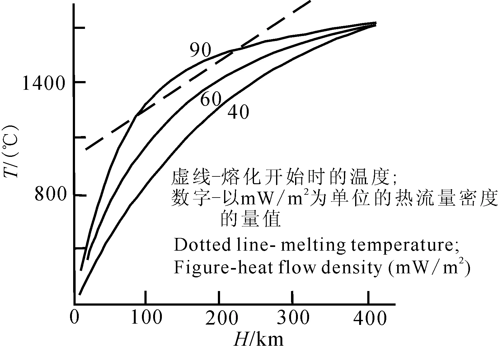
圖1 大陸的地溫分布(據ВАНЪЯН,2001)Fig.1 The geothermal distribution of the continent (ВАНЪЯН,2001)
3 大地熱流值估算上地幔頂面埋深
大地熱流是地球內熱向地表傳輸,并在地表單位面積上向外部空間散發的熱量,常以下式表示:
(1)
從上面公式可以看出,大地熱流值與地溫梯度和巖石的導熱率成正比,而巖石電阻率又與地下深部的溫度密切有關,當溫度達到巖石的初始熔融溫度(即巖石的固相線)時,其值急劇下降.dám(1978)統計了多個地區的大地熱流值與上地幔頂面深度的關系,得出大地熱流值(Q)與上地幔頂面深度(HL)之間的經驗公式:
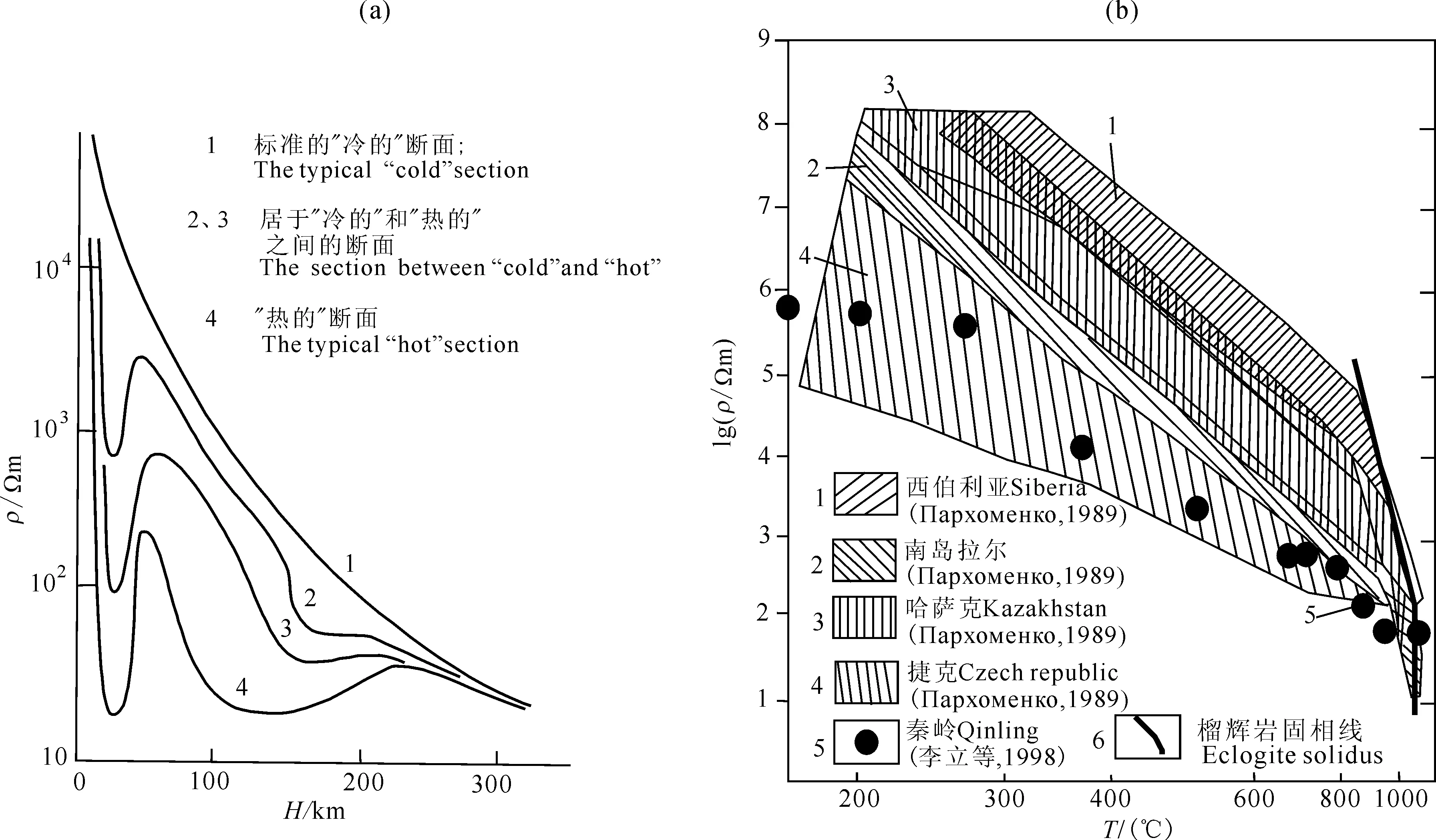
圖2 (a)大陸地殼和上地幔的綜合地電斷面(據ВАНЪЯН,2001); (b)榴輝巖高溫高壓電阻率測試結果(據Пархоменко,1989;李立等,1998)Fig.2 (a) Geoelectric sections of continental crust and upper mantle (ВАНЪЯН,2001); (b) Eclogite resistivity under high temperature and high pressure condition(Пархоменко,1989;Li et al. 1998)
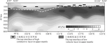
圖3 中國沿北緯39°線的深部地球物理剖面(在Liu et al.2004年結果上補充了MT結果)Fig.3 Deep geophysical profile along the N39°line of China (added the MT on the basis of the result of Liu et al.2004)
(2)
式中HL為上地幔頂面埋藏深度(單位為km),Q以HFU為單位的大地熱流值.目前我們使用的大地熱流值(Q′)的單位是mW·m-2,1HFU=41.87 mW·m-2.因此,公式(2)中的Q=Q′/41.87, 即
(3)
選擇了二條同時開展大地電磁測深和大地熱流工作的地學剖面,對大地熱流值估算的上地幔頂面深度與大地電磁測深反演的上地幔高導層深度進行了對比,一條是內蒙古東烏珠穆沁旗—遼寧義縣地學剖面(史書林等,1991),另一條是黑龍江黑河—吉林扶余地學剖面,對比結果見圖4和圖5.從圖中可以看出,用大地熱流值估算的上地幔頂面深度(HL)與大地電磁測深反映的深度接近,其變化形態特征也基本一致,說明dám經驗公式應用在我國境內是可行的.
為了進一步證明利用大地熱流值估算上地幔頂面深度的可行性,選擇了地熱研究程度較高,大地熱流資料豐富,而大地電磁測深資料極少的塔里木盆地做了對比研究.馮昌格等(2009)利用塔里木盆地的大量地溫測井資料和巖石熱導率數據,計算了塔里木盆地大地熱流值,獲得了全盆地的大地熱流圖,而塔里木盆地大地電磁測深數據很少,只有1條地學斷面的4個大地電磁測深點和1個位于葉城凹陷內的測深點.用dám經驗公式,根據馮昌格發表的塔里木盆地大地熱流值估算了該盆地上地幔頂界面深度(圖6).從圖中可見盆地內的5個大地電磁測深獲得的上地幔高導層頂界面深度與根據大地熱流估算的結果吻合得很好,這也證明在沒有大地電磁測深資料的地區可利用大地熱流值估算上地幔頂界面深度.
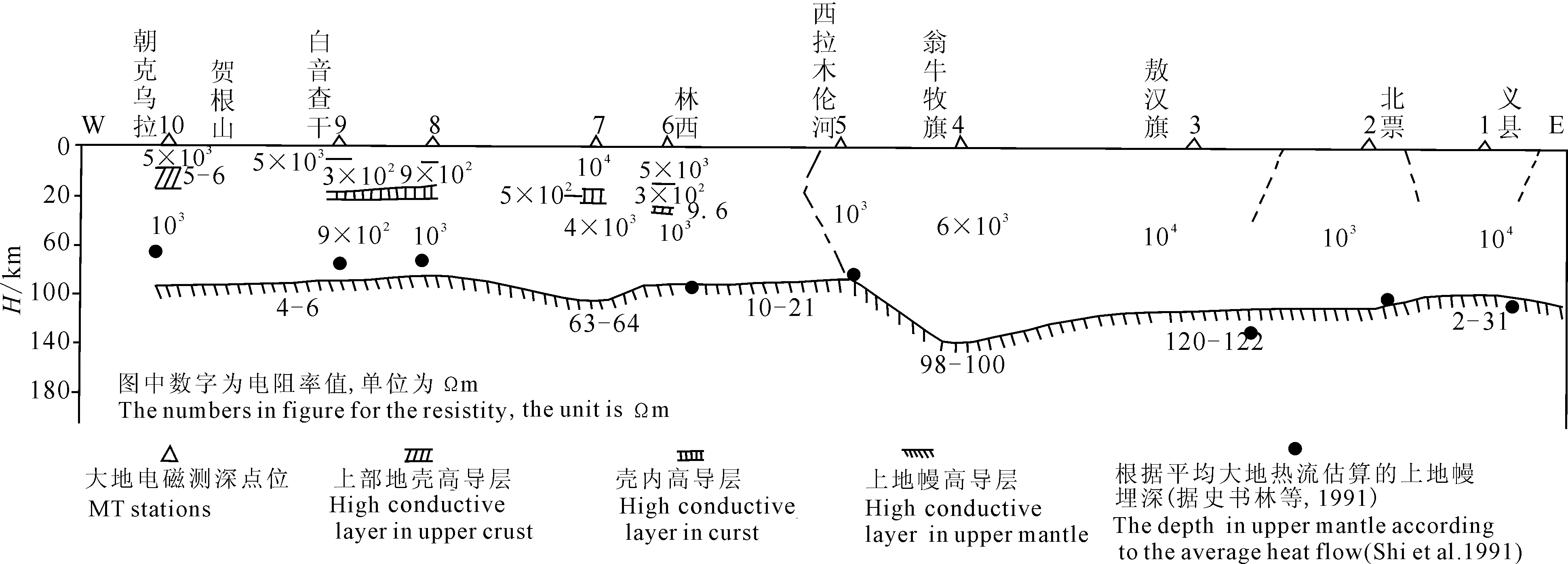
圖4 義縣—東烏珠穆沁旗大地電磁反演上地幔高導層深度與大地熱流值估算上地幔深度對比Fig.4 The depth of high conductive layer in upper mantle according to MT and the average heat flow along Yixian-East Ujimqin profile

圖5 黑龍江黑河—吉林扶余剖面大地電磁反演結果與大地熱流估算上地幔高導層埋深對比Fig.5 The depth of high conductive layer in upper mantle according to MT and the average heat flow along Heihe-Fuyu profile
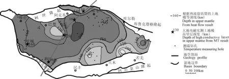
圖6 塔里木盆地上地幔頂界面深度圖(據馮昌格等(2009)大地熱流值估算)Fig.6 The top interface in upper mantle in Tarim basin (according to Feng et al. (2009) heat flow resluts)
鄧晉福等(2008)通過對比不同資料對巖石圈厚度的研究結果發現,大地電磁測深與大地熱流所得出的巖石圈厚度吻合率高達80%(誤差在10%~15%以內).
因此,本文在部分較大的空白區收集了大地熱流值的資料,用它的估算結果補充完善上地幔高導層頂界面深度.
4 中國大陸上地幔高導層的分布特征
4.1 中國大陸上地幔高導層頂面深度圖編制
在李立(1996)發表的中國大陸1°×1°上地幔高導層頂界面深度圖的基礎上,補充了1997—2010年期間,我們自己實測的大地電磁測深數據和國內各種刊物公開發表的大地電磁測深上地幔高導層頂界面深度,在部分較大的空白區補充了大地熱流數據.收集了青藏高原大地電磁測深資料(張勝業等,1996;孔祥儒等,1996;馬曉冰等,2001;劉宏兵等,2001;孫潔等,2003;譚捍東等,2004;趙國澤等,2004,2008;湯吉等,2005;馬曉冰等,2005;金勝等,2006,2009,2010;魏文博等,2006a,2009);東北地區大地電磁測深資料(牛雪和盧造勛,1998;盧造勛等,2005;劉國興等,2006a,2006b;劉財等,2009);其他地區大地電磁測深資料(鄧前輝等,1990,2001;徐常芳,1996;李立等,1998a,1998b;趙國澤等,1997,1999,2009;詹艷等,2000,2004,2008;楊文采等,2005;朱介壽等,2005;魏文博等,2006b;于鵬等,2008;張森琦等,2008;葉高峰等,2009;張繼紅等,2010;王鑫等,2010);大地熱流數據(王鈞等,1995;馮昌格等,2009).將獲得的上地幔高導層頂界面深度,按經緯度1°×1°的網度為單元,對網格內所有測點上地幔高導層的深度求取平均值,作為相應單元內的上地幔高導層頂面深度值.本次參與編圖所用的1°×1°網度的上地幔頂面深度數據分布情況見圖7.從圖中可以清楚地看出東部地區的數據情況明顯要好于西部地區的,西部缺數據區域主要集中在高山地區,如昆侖山脈、阿爾金山、岡底斯山脈、念青唐古拉山等地區.根據1°×1°經緯網度的上地幔高導層頂面深度數據,編制了中國大陸上地幔高導層頂界面深度圖(圖8).
4.2 中國大陸上地幔高導層的分布特征
從圖8中可以看出,我國上地幔高導層頂面深度具有南北分帶、東西分塊的特征,以南北地震帶為界,東部淺,西部深;以西昆侖—秦嶺—大別山—上海為界,北部淺,南部深的分布態勢.其深度變化很大,最淺處位于東北松遼盆地,深度為50~60 km,最深處位于長沙-桂林一帶,深達230 km,平均深度約為100~120 km.根據中國大陸上地幔高導層頂界面深度的隆坳格局,將我國大陸劃分了27個上地幔高導層的隆起區(巖石圈的減薄區),每個隆起區根據所處位置進行了命名,并統計了其頂面深度,結果見表1.從表中可以看出,上地幔高導層隆起區多數對應于高熱流區與強地震分布區,具有活動構造帶的特征,多位于現今的裂谷、盆地構造之下,深部的上地幔高導層與其上部的盆地、裂谷呈鏡像關系.例如華北裂谷盆地(江釗等,1990)(圖9)、汾渭裂谷(鄧晉福等,2008; 刑集善等,1989)(圖10)等.
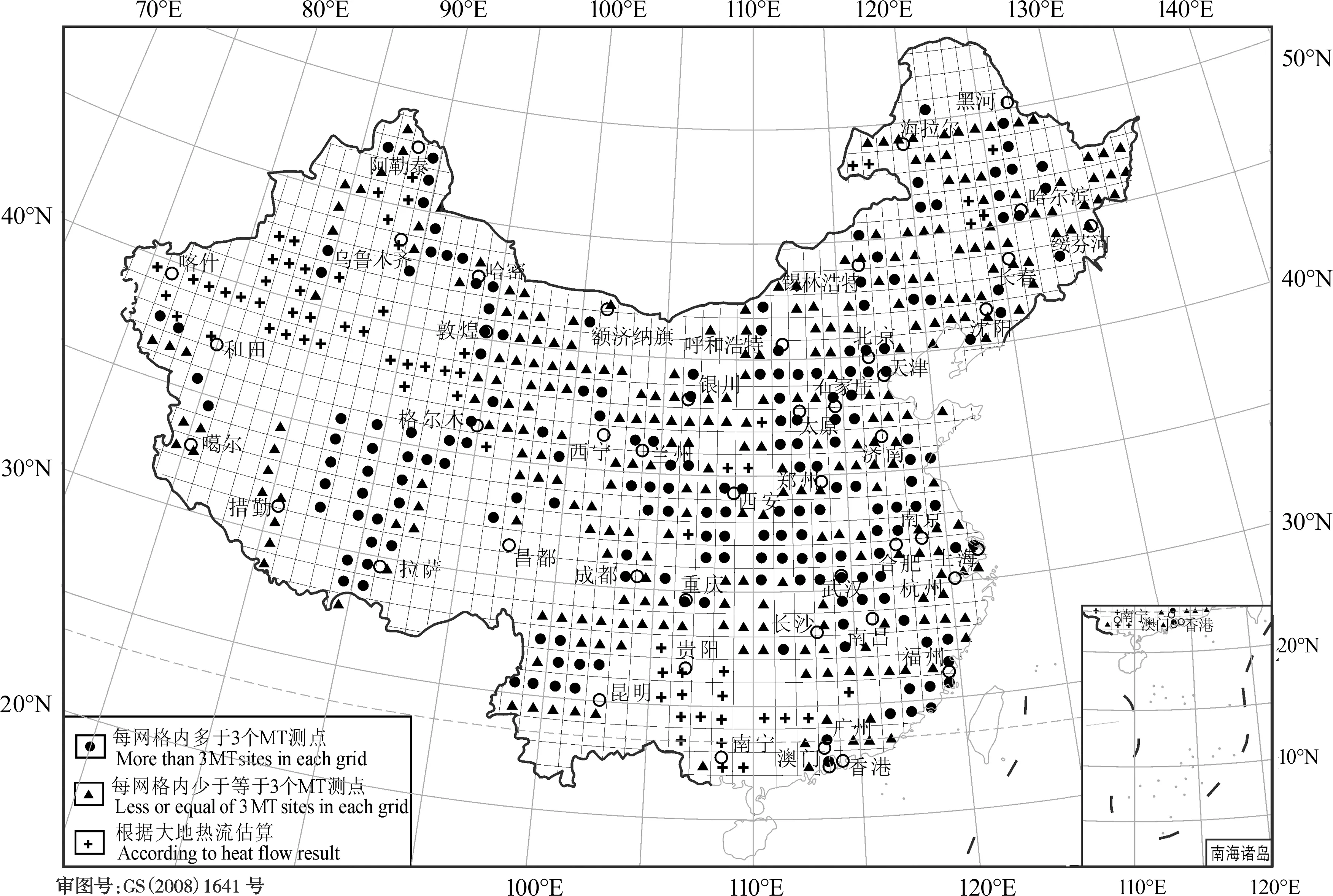
圖7 中國大陸大地電磁測深研究程度圖Fig.7 The research intensity map of MT method in the continent of China
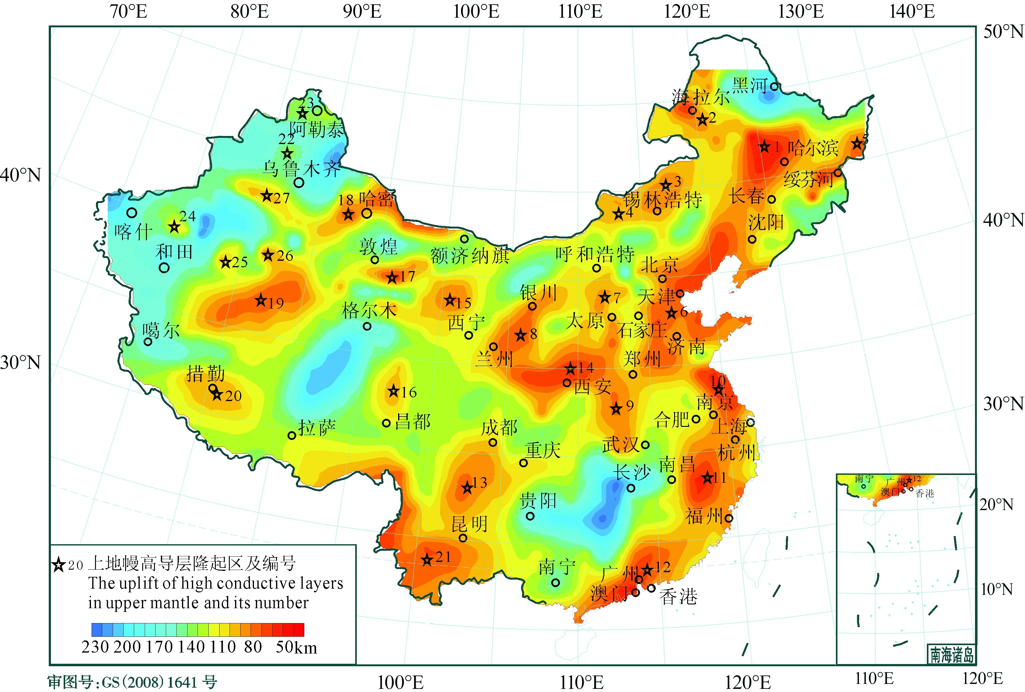
圖8 中國大陸上地幔高導層頂界面深度圖Fig.8 The depth of the top interface of the high conductive layer in upper mantle in the continent of China
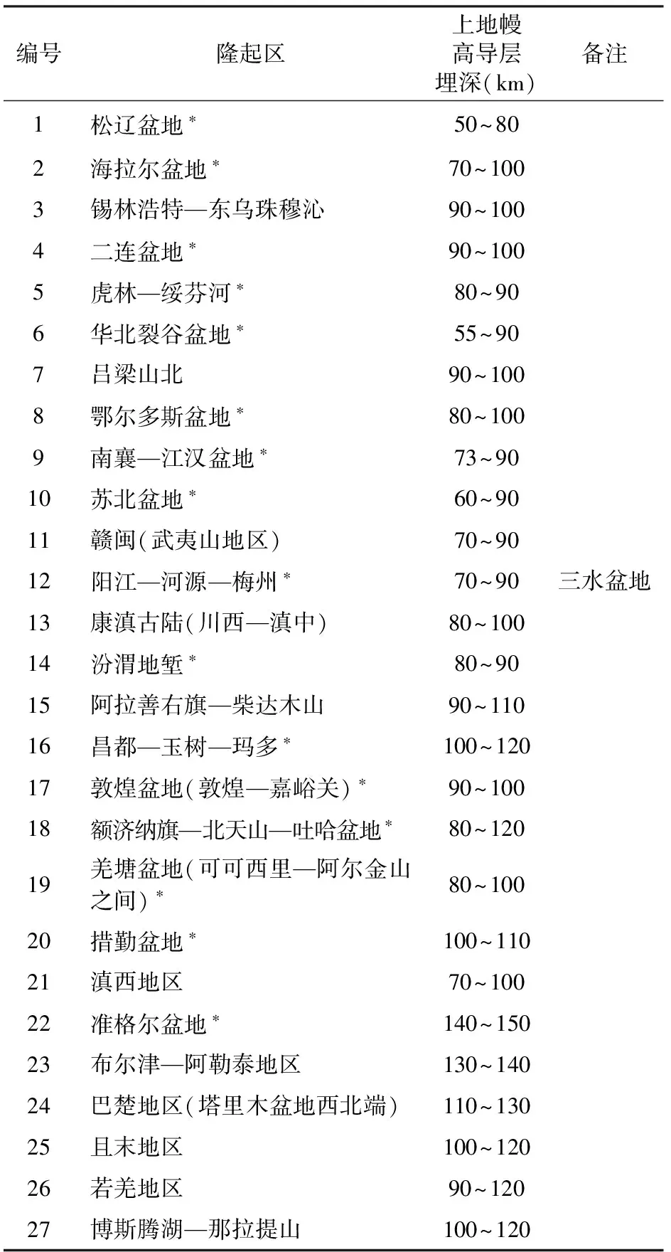
編號隆起區上地幔高導層埋深(km)備注1松遼盆地?50~802海拉爾盆地?70~1003錫林浩特—東烏珠穆沁90~1004二連盆地?90~1005虎林—綏芬河?80~906華北裂谷盆地?55~907呂梁山北90~1008鄂爾多斯盆地?80~1009南襄—江漢盆地?73~9010蘇北盆地?60~9011贛閩(武夷山地區)70~9012陽江—河源—梅州?70~90三水盆地13康滇古陸(川西—滇中)80~10014汾渭地塹?80~9015阿拉善右旗—柴達木山90~11016昌都—玉樹—瑪多?100~12017敦煌盆地(敦煌—嘉峪關)?90~10018額濟納旗—北天山—吐哈盆地?80~12019羌塘盆地(可可西里—阿爾金山之間)?80~10020措勤盆地?100~11021滇西地區70~10022準格爾盆地?140~15023布爾津—阿勒泰地區130~14024巴楚地區(塔里木盆地西北端)110~13025且末地區100~12026若羌地區90~12027博斯騰湖—那拉提山100~120
注:*為上地幔高導層隆起區對應于淺表已知含油氣盆地.
通過對上地幔高導層的研究發現,它們的埋深與分布不僅與內生金屬礦產的分布有關,還與油氣藏的分布有關.
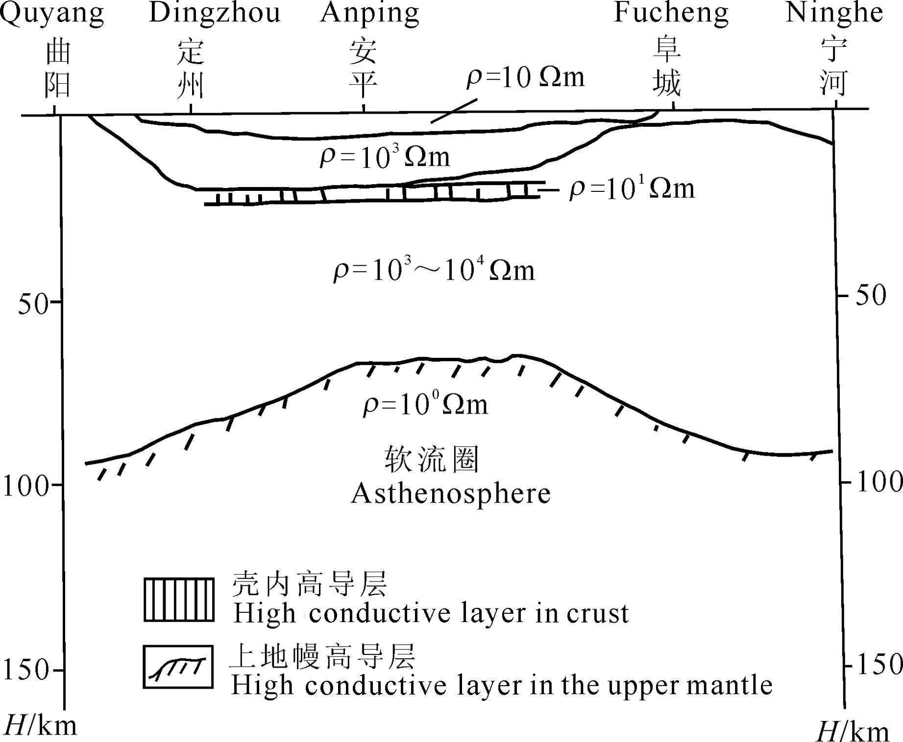
圖9 華北裂谷盆地大地電磁測深結果(在江釗等1990的基礎上增加了新資料)Fig.9 MT result in the rift basin of NC (new data was added base on Jiang et al.1990)
5 上地幔高導層與內生金屬礦產分布的關系
國內外有關專家從不同的角度出發,研究了內生金屬礦產的分布與深部構造之間的關系(Щеглов,1990; 徐兆文等,1996).Щеглов通過對世界各地金屬礦產的研究認為錫、鎢礦產一般富集于上地幔隆起的長垣或地幔底辟上方,地幔隆起的斜坡上方(特別是陡傾的梯度帶上方)常易富集銅、鉛、鋅、鉬等礦產.上部地幔的起伏受控于軟流圈的起伏(單家增等,1987).Щеглов還指出,上述地幔形態的不均勻形變有其繼承性,能長期存在,它們對各時代礦藏的形成都是有利的.雖然地球物理探測的深部地電特征反應現代的深部狀態,但由于發生在早期的深部地球物理場有它的存留性,不可能在短時間內消失,就拿對巖石電阻率影響較大的溫度場來說,并不是瞬間就能下降的,如果將巖石圈內某一地段的溫度從軟流圈上涌時的1200 ℃(地幔巖石熔融狀態的最低溫度)降至500~600 ℃絕不是瞬間所能達到的.有人從理論上計算了古深部構造存留的時間,至少可達2~3億年之久(葛良勝等,2009),這與Щеглов所說的地幔形態的不均勻性能長期存在基本一致.下面舉兩個實例來說明.
(1) 云南哀牢山地區用地球物理方法仍可清晰地識別出晚古生代至中生代早期發生的明顯的軟流圈上隆事件(葛良勝等,2009),在早期軟流圈隆起的背景下,又疊加了晚期軟流圈隆起的效應,并得出了該礦集區軟流圈多期脈動隆起的成礦模型(圖11).
(2) 四川攀西古裂谷帶是加里東—印支期的古裂谷,初始形成于加里東期(500 Ma前),海西早期擴大張裂,印支末期-燕山期裂谷萎縮消亡(張洪榮和蔣航,1988).從大地電磁測深在攀西裂谷上的觀測結果(圖12)來看,總體上已觀測不到現代裂谷那樣強烈的熱流異常以及探不到底界的上地幔低阻異常(李立和金國元,1987),但它還保留了軟流圈上隆的痕跡——上隆的很薄的上地幔高導層.除此,在古裂谷帶巖石圈內得到巨厚的高阻異常,說明這里曾經有過大量的幔源巖漿巖上涌,現已冷卻形成了巨大的高阻異常.據張洪榮和蔣航(1988)的資料,攀西裂谷帶內生金屬礦產的成礦時間貫穿于晚加里東期、海西期、印支期和燕山期,它的成穹期、破裂期、升降期及萎縮期都是內生金屬礦產的成礦期.內生礦產主要分布于裂谷軸部的斷裂帶上方,深部與曾經的軟流圈上隆相對應.
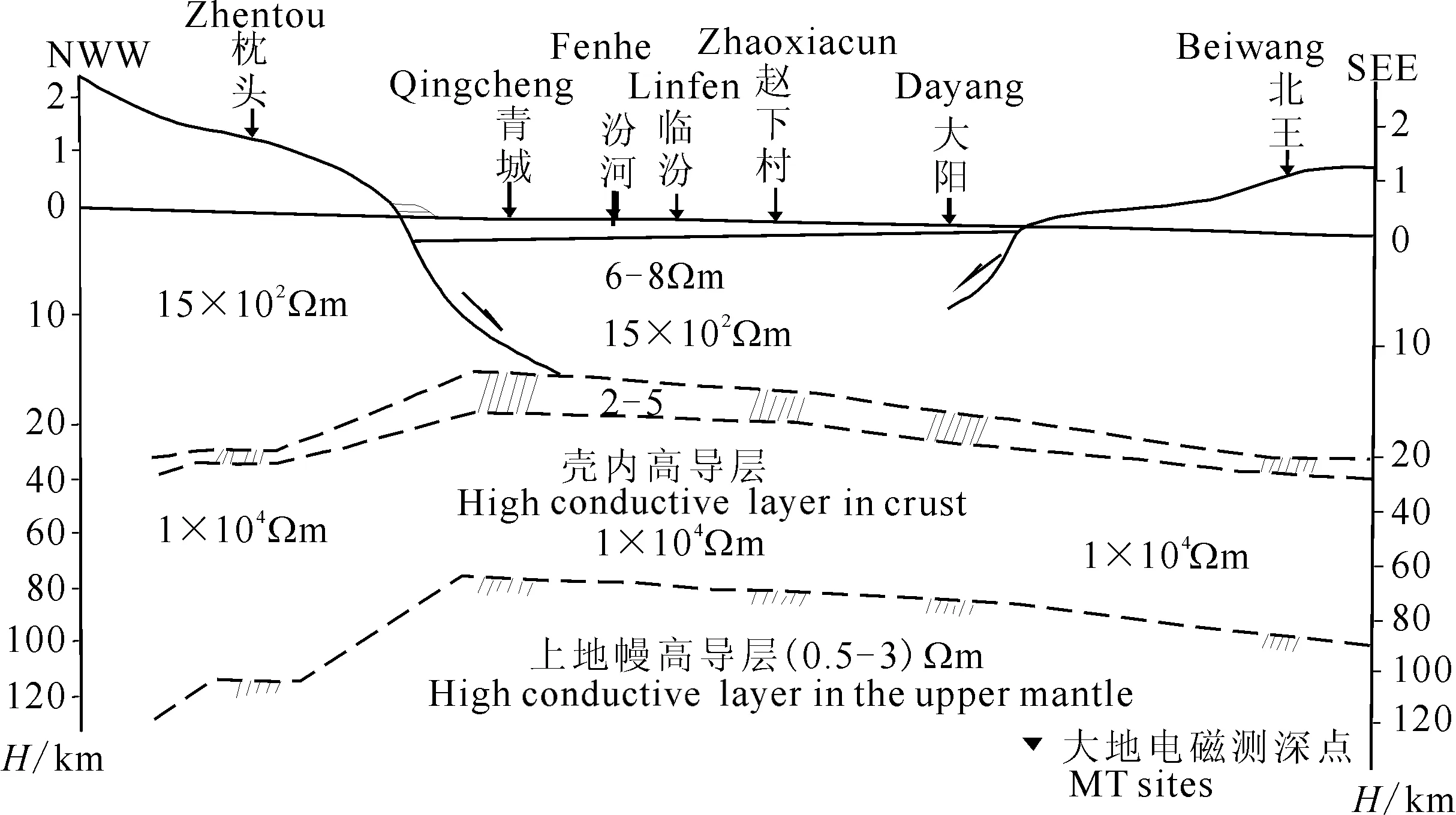
圖10 汾渭地塹系上的大地電磁測深結果(據鄧晉福等,2008; 刑集善等1989)Fig.10 MT result in Fenwei graben system(Deng et al. 2008; Xing et al. 1989)
圖11 哀牢山礦集區殼幔結構與礦產分布(葛良勝等,2009資料簡化)Fig.11 Crust mantle structure and distribution of mineral resources at Ailao Mountain ore district (Simplified Ge et al.2009)
秦嶺地區是我國重要的成礦區之一,是研究礦產分布與深部構造關系的有利地區.物化探所于1997—1999年從深部電性特征的研究著手,探索了秦嶺地區深部地電結構與內生金屬礦產分布之間的關系(Li et al.,1999).從圖13中可以看出,礦床大部分位于上地幔高導層的突起或其兩側的陡傾梯度帶上方,其中的鉬、鎢礦床多位于突起上方,而銅、鉛、鋅、金、銻、汞等分布于上地幔高導層的陡傾梯度帶上方,上地幔高導層的凹陷區很少有內生金屬礦產分布.
在此基礎上,我們又將中國內生金屬成礦圖(郭文魁和劉夢庚,1989)上的中生代以來的鎢、錫、鉬、銻、金、鐵、鉻、銅、鎳、鉛、鋅、汞12種元素的已知內生金屬礦床疊合在中國大陸上地幔高導層頂界面深度圖上(圖14),并對12種元素的礦產分別進行了統計,結果如圖15所示,不論哪種元素的內生礦床80%以上分布在上地幔高導層頂界面梯度帶、隆起帶上方.軟流圈的不斷隆升,造成巖石圈減薄、拉張,張性斷裂的出現成為地球深部物質和熱量向地殼上部運移的有利通道.而地球深部存在超臨界流體,它能從礦源中萃取金屬和非金屬成礦元素,形成多組分的成礦混合溶液,由于它的溶解能力較強, 能有效地溶解成礦物質,而且極易與圍巖發生相互作用,形成各種構造裂隙或次生溶孔,改善運移條件,為成礦物質搬運起著重要的作用(王傳遠等,2005).因此可以說上地幔高導層頂界面梯度帶、隆起帶是地幔物質上涌的通道,是形成內生金屬礦產的有利地區;超臨界流體對成礦物質運移可能發揮了重要作用,深入研究上地幔高導層的形態,能為內生金屬礦產的預測提供重要依據.
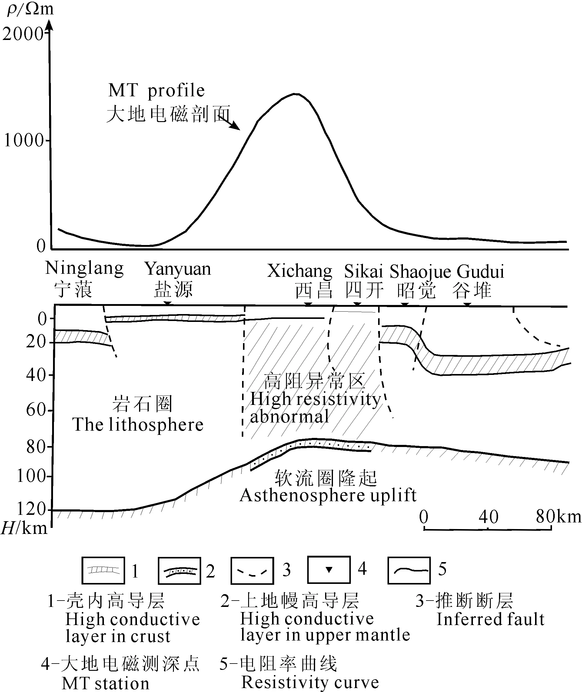
圖12 攀西裂谷帶大地電磁測深推斷剖面圖 (據李立等,1987)Fig.12 MT section in the western Panzhihua rift belt (Li et al.1987)
6 上地幔高導層的隆坳格局與油氣藏的對應關系
為了研究上地幔高導層的分布與已知油氣藏是否存在某種對應關系.將現已發現的油氣田以及含油氣盆地與全國上地幔高導層深度圖疊合在一起(見圖14),從圖14和表1可以看到如下規律:我國東部地區主要含油氣盆地主體對應上地幔高導層隆起區,油氣田多位于隆起區上方或其邊部的過渡帶上,如松遼盆地、渤海灣盆地、二連盆地等.西部地區大型盆地主體位于幔坳區,如塔里木盆地,主要油氣田對應于盆地中心的幔坳向周邊幔隆過渡的梯度帶上;中部地區主要含油氣盆地表現為僅盆地腹地對應幔坳,盆地周邊地區對應規模較大的上地幔高導層隆起區,如鄂爾多斯盆地,主要油氣田就位于上地幔高導層隆起區.這一特征與中國東部多熱盆、西部多冷盆、中部多中熱盆的盆地熱結構特征一致(羅志立,1999).
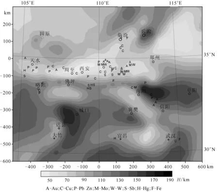
圖13 秦嶺地區上地幔高導層深度(據Li et al.1999)與中生代內生金屬礦床的分布(據郭文魁等,1989;徐兆文等,1996)Fig.13 The depth of high conductive layer in upper mantle (Li et al.1999) and distribution of the Mesozoic endogenetic metallic ore in Qinling area (Guo et al.1989;Xu et al.1996)
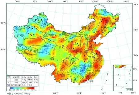
圖14 中國大陸上地幔高導層頂界深度與已知內生金屬礦、油氣田分布1松遼盆地;2二連盆地;3海拉爾盆地;4虎林盆地;5三江盆地;6華北裂谷盆地;7南華北盆地;8鄂爾多斯盆地;9蘇北盆地;10四川盆地;11額濟納旗—銀根盆地;12柴達木盆地;13準噶爾盆地;14塔里木盆地;15羌塘盆地;16措勤盆地.Fig.14 The depth of high conductive layer in upper mantle and the distribution of endogenetic metallic ore and oil gas field in the continent of China
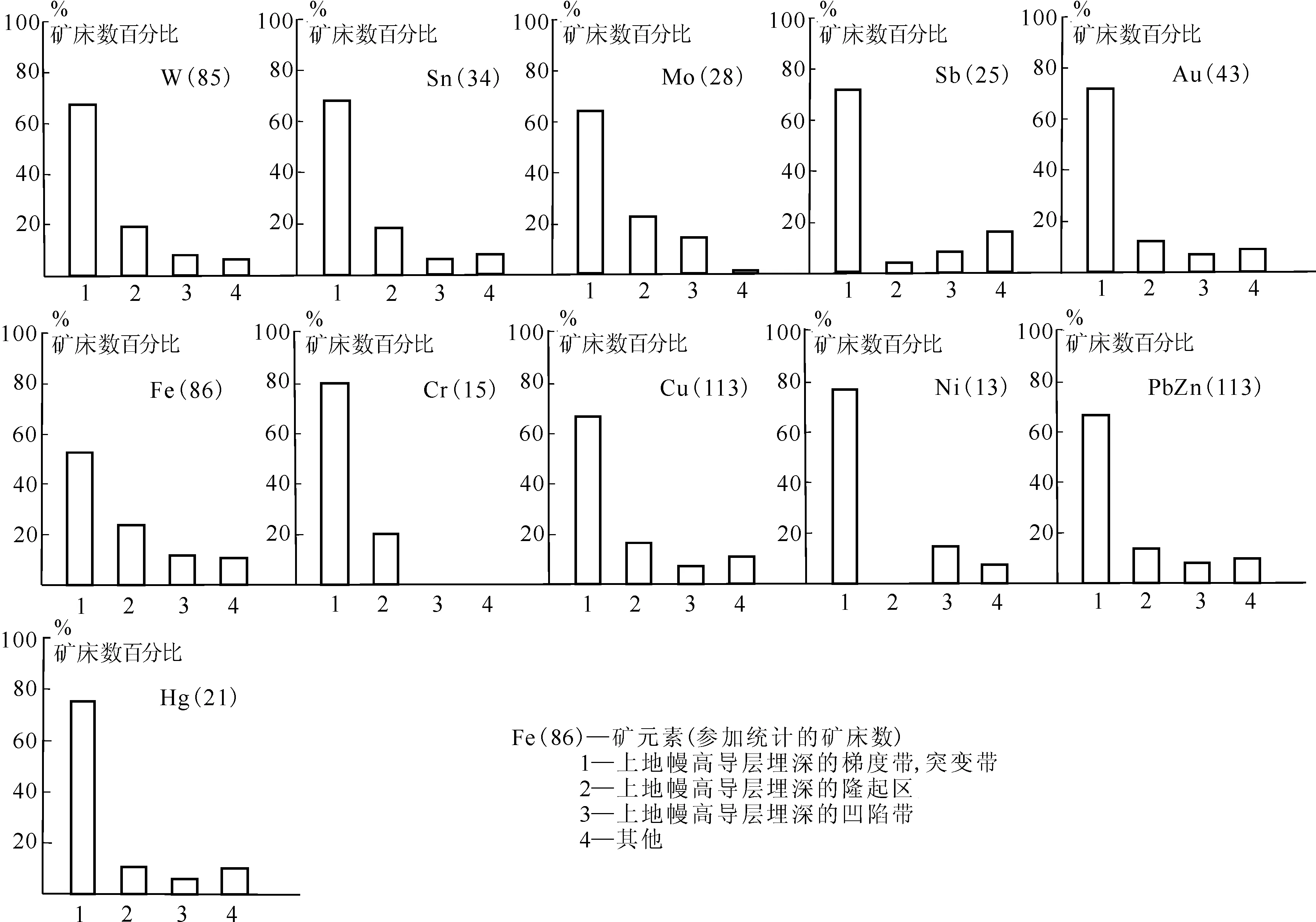
圖15 上地幔高導層的形態與內生金屬礦產分布的相關圖Fig.15 Correlogram of the pattern of high conductive layer in upper mantle and endogenetic metallic ore distribution
地殼深部構造及其演化控制著盆地的形成,進而控制著盆地內油氣的生成、運移和聚集.軟流圈的隆起,使巖石圈拉伸變薄,會造成基底發生裂陷或坳陷成盆.如松遼盆地的形成過程就是由于庫拉—太平洋板塊向歐亞大陸之下俯沖,導致地幔隆起促使地殼拆沉減薄,同時導致上地殼伸展沉降及其后期的熱沉降,形成大型斷陷、坳陷盆地,表現出盆地整體凹陷與地幔凸起成鏡像關系(云金表等,2003)(圖16).軟流圈的隆起常伴有地幔底辟的產生,使巖石圈拉張變薄,形成一系列大體平行的深大斷裂束(多為近于直立的正斷層),由于斷裂密集,形成了一個高滲透帶,深部的巖漿、氣體、液體可以大規模上涌,并在地殼內的有利地段富集成藏.深反射地震資料就揭示松遼盆地深部可能有熱流底辟體由上地幔進入地殼上部(云金表等,2003).來自地幔的流體( 包括二氧化碳和大量烴等氣體) 不僅可以直接形成天然氣藏, 也有利于盆地內生物的大量繁殖, 并為生物有機質生烴演化提供溫度條件( 李楊鑒等,1996).
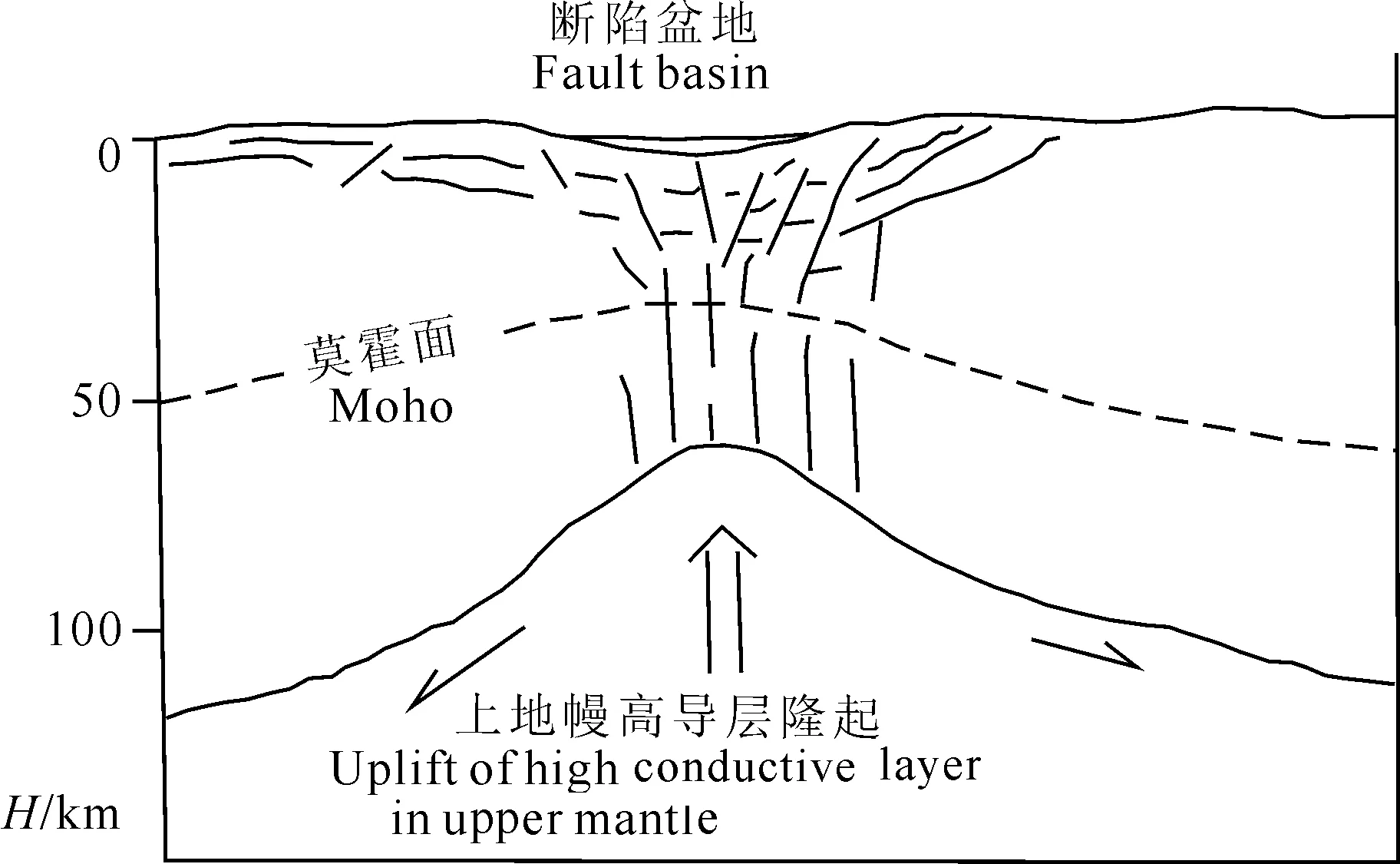
圖16 上地幔高導層隆起與淺部盆地的鏡像關系示意圖Fig.16 The image relationship between the uplift of high conductive layer in upper mantle and shallow basin
近年來一系列油田的原油微量元素分析發現,源于地幔流體的異常高的金屬微量元素,它們不是源于沉積巖(戴金星等,1995;滕吉文等,2009),例如:塔里木油田原油中的V、Ni;塔里木油田瀝青中的Pb、Sr、Nd;勝利油田原油中的Au;遼河油田原油中的Pb、Sr、Nd;大慶油田原油中的金屬U等等.油氣中常含或伴生有多種可能來自地球深部的氣體或金屬元素等,揭示了它們在成因上有著一定的關聯.對這種現象的解釋目前存在兩種觀點:一是認為油氣或伴生的金屬元素可能都來源于深部地幔,油氣是無機成因的.這種無機生油假說已經得到地質實地觀察、化學室內合成和工業生產等方面的支持(袁學誠和李善芳,2012).根據化學熱力學理論分析,只有當壓力大于3×10⁶kPa(相當于地表下深度大于100 km處),溫度大于700 ℃時,H-C體系才能生成乙烷及更重的碳氫化合物.松遼盆地和塔里木盆地都發現了非生物成因烴類物質的跡象(郭占謙等,1998;王先彬等,2009).還有一種觀點認為來自深部的超臨界水提供了大量的氫離子,使有機質熱解生成的碎片能立即加氫而穩定,尤其是對貧氫的腐質型有機質導致了液態烴產率的提高,同時溶解和擴散能力很強的深部熱流體所攜帶的高熱能可使沉積盆地的地溫升高, 加快烴源巖的熱演化, 促進油氣的生成(王傳遠等,2005).
總之,油氣田的成礦環境也與深部動力環境、深部物質的運移有關,使油氣田的產出位置與軟流圈上隆或地幔底辟的分布存在空間上的對應關系.中國已發現的油氣田多與活動斷裂相伴分布,表明油氣田分布與現今地殼運動存在著內在聯系(彭威和郭占謙,2001),這也許是這種對應關系的地表顯現.
無論是內生金屬礦床的分布,還是油氣田的分布都與軟流圈隆起區存在空間上的對應關系.但二者在空間位置上并未重疊,前者分布在上地幔隆起區靠近造山帶一側,后者分布在上地幔隆起區靠近盆地一側, 在空間上形成了“礦包油”的態勢.來自地球深部的物質和熱量,不僅在含油氣盆地周邊的造山帶中形成了熱液礦床,同時還為含油氣盆地帶來了生烴催化劑和無機生成的石油與天然氣,就是熱液礦床與油氣田相伴分布的緣故與內在聯系(郭占謙,2001).
7 結論
(1)我國大陸上地幔高導層頂面深度分布具有南北分帶、東西分塊的特征,總體表現為東部淺,西部深,北部淺,南部深.上地幔高導層頂面深度變化很大,最淺位于東北的松遼盆地,深度僅50~60 km;最深位于長沙-桂林一帶,深達230 km,平均深度一般為100~120 km.根據其分布形態特征,將我國大陸上地幔高導層劃分出27個隆起區.
(2)我國大陸中生代內生金屬礦床的分布與上地幔高導層的隆坳格局有很好的相關性,80%以上的內生金屬礦產分布于上地幔高導層隆起帶上方或其梯度帶上方.
(3)我國大陸含油氣盆地分布特征具有明顯的三分性.東部地區含油氣盆地主體對應上地幔隆起區,油氣田多位于隆起區上方或其邊部的過渡帶上;西部地區主體位于幔坳區,油氣田多對應于盆地中心的幔坳向周邊幔隆過渡的梯度帶上;中部地區表現為僅盆地腹地對應幔坳,盆地周邊對應規模較大的上地幔隆起區,主要油氣田位于上地幔隆起區.無論是內生金屬礦床的分布,還是油氣田的分布都與上地幔隆起區存在空間上的對應關系,前者分布在上地幔隆起區靠近造山帶一側,后者分布在上地幔隆起區靠近盆地一側.
(4)上地幔隆起區是地球深部的物質和熱量向地殼上部運移的有利通道,為內生金屬礦產的形成提供了成礦物質和能量的保障,也為含油氣盆地帶來了生烴催化劑、熱能和無機生成的石油與天然氣.地球深部超臨界流體的存在對上幔高導層的形成、成礦物質運移可能發揮了重要作用.
(5)充分利用已有的深部地球物理資料,進一步開展區域三維大地電磁測深工作,獲得上地幔高導層更精細的空間發育狀態,可為尋找新的大型金屬礦產與油氣藏提供重要依據.
致謝 成文過程中,中國地質調查局發展研究中心袁學誠教授提出了很多寶貴意見和建議;外審專家提出了寶貴的修改意見,在此一并表示感謝.
Щеглов АД. 1990. Эндогенная металлогения и тектоносфера. Геотектоника, (5): 9-16.ВАНЪЯН Л Л. 2001. Electromagnetic sounding. Beijing: Oceanography Publishing House.
ádám A. 1978. Geothermal effects in the formation of electrically conducting zones and temperature distribution in the Earth.Phys.EarthPlan.Int., 17(2): 21-28.
Chen L, Zhu R X, Wang T.2007. Progress in continental lithosphere studies.EarthScienceFrontiers,14(2):58-75
Dai J X, Song Y, Dai C S, et al. 1995. Inorganic Gas and Its Reservoir Forming Conditions in Eastern China (in Chinese). Beijing: Science Press.
Deng Q H, Liu G D, Liu J H, et al. 1990. The observation of magnetotelluric and electrical characteristics of the crust-upper mantle along Hubei Xiangfan-Fujian Luoyuan profile.SeismologyandGeology(in Chinese), 12(2): 149-158.Deng Q H, Wang J J, Tang J, et al. 2001. Electrical structures of the crust and upper mantle in Sanhe-PingguM8 earthquake area, China.SeismologyandGeology(in Chinese), 23(2): 178-186.
Deng J F, Teng J W, Peng C, et al. 2008. The Geophysical Field Character and Deep Geological Prospecting (in Chinese). Beijing: Geological Publishing House, 59-62
Feng C G, Liu SW, Wang L S, et al. 2009. Present-day geothermal regime in Tarim basin, northwest China.ChineseJournalofGeophysics(in Chinese), 52(11): 2752-2762.
Ge L S, Deng J, Guo X D, et al. 2009. Deep-seated structure and metallogenic dynamics of the Ailaoshan polymetallic mineralization concentration area, Yunnan province, China.ScienceinChina(SeriesD):EarthSciences(in Chinese), 52(10): 1624-1640.
Guo W K, Liu M G. 1989. The Map of Endogenous Mineral Ore in China. Beijing: Geological Publishing House.
Guo Z Q.2001. Minerallied hydrothermal liquid and petroleum generation.XinjiangPetroluemGeology,22(3):181-184
Guo Z Q,Feng Z H,Wang P Z.1998. Coexisting elements and geochemical characteristics in crude oil of Tarim basin.PetroleumExplorationist,3(1):34-36.Jiang Z, Sun H, Xu C F, et al. 1990. Jiangsu Xiangshui-Electrical structure of crust and upper mantle Inner Mongolia Kathmandu.SeismologyandGeology(in Chinese), 12(3): 193-199, 206.Jin Z M, Bai W M. 1993. Dynamical partial melting and its geophysical significances.GeologicalScienceandTechnologyInformation(in Chinese), 12(1): 93-100.
Jin S, Ye G F, Wei W B, et al. 2006. The electrical structure and fault feature of crust of south-eastern Tibetan plateau——the result of magnetotelluric prospecting on profile from Xiachayu-Changdu.EarthScienceFrontiers(in Chinese), 13(5): 408-415.Jin S, Wei W B, Ye G F, et al. 2009. The electrical structure of Bangong-Nujiang suture: results from magnetotelluric sounding detection.ChineseJournalofGeophysics(in Chinese), 52(10): 2666-2675.
Jin S, Wei W B, Wang S, et al. 2010. Discussion of the formation and dynamic signification of the high conductive layer in Tibetan crust.ChineseJournalofGeophysics(in Chinese), 53(10): 2376-2385.
Kong X R, Wang Q S, Xiong Z B. 1996. Integrated geophysical and lithosphere structure research in the western Tibet.ScienceinChina(SeriesD) (in Chinese), 26(4): 308-315.
Li L, Jin G Y. 1987. Telluric electromagnetic sounding study of crust and upper mantle in the Panxi “rift zone” and the Longmenshan faulted zone.GeophysicalandGeochemicalExploration(in Chinese), 11(3): 161-169.
Li L. 1996. The geoelectrical characteristic of crust and upper mantle in the continental region of China.ActaGeophysicaSinica(in Chinese), 39(S1): 130-140.
Li L, Yang P Y, Duan B, et al. 1998a. The lithospheric geoelectric model of east Qinling.ActaGeophysicaSinica(in Chinese), 41(2): 189-196.
Li L, Jin G Y, Liu Y H, et al. 1998b. The contrast of lithospheric electrical structure between east and west Qinling orogen.TheAbstractsofChineseLearnedPeriodical(BulletinofScienceandTechnology) (in Chinese), 4(7): 840-844.
Li L, Jin G Y, Yang P Y, et al. 1999. Geoelectrical structure of the crust and upper mantle in the Qinling and adjacent regions.ContinentalDynamics, 4(1): 70-77.
Li Y J, Zhang X L,Chen Y C. 1996. Continent al Layer Controlled Tectonics Introduction. Beijing: Geological Publishing House. 82-95.
Liu H B, Kong X R, Ma X B, et al. 2001. The physical property and structure characteristics of the Southeastern of the Qinghai-Tibet plateau crust.ScienceinChina(SeriesD) (in Chinese), 31(Suppl.): 61-65.
Liu M, Cui X J, Liu F T. 2004. Cenozoic rifting and volcanism in eastern China: a mantle dynamic link to the Indo-Asian collision?.Tectonophysics, 393(1-4): 29-42.
Liu G X, Zhang X Z, Yang B J, et al. 2006a. Electrical structures of the lithosphere along the Jiamusi massif and its eastern edge.ChineseJournalofGeophysics(in Chinese), 49(2): 598-603.
Liu G X, Zhang Z H, Han J T, et al. 2006b. Features of the electric structure of the lithosphere beneath the Hinggan-Inner Mongolia and Jilin-Heilongjiang regions.GeologyinChina(in Chinese), 33(4): 824-831.
Liu C, Zhang X Z, Liu Y, et al. 2009. Geoelectrical evidence for characteristics of lithospheric structure beneath the Yuejinshan collage zone and its vicinity in Northeast Asia.ChineseJournalofGeophysics(in Chinese), 52(4): 958-965.
Lu Z X, Jiang D L, Bai Y, et al. 2005. Exploration and research on the structure of the crust and upper mantle in northeast China.SeismologicalResearchofNortheastChina(in Chinese), 21(1): 1-8.
Lu FX. 1989. The Mantle Petrological (in Chinese). Wuhan: China University of Geosciences Press, 28-29.
Luo Z L.1999. Discussion on the uniqueness of the petroleum geological conditions in China.PetroleumExplorationist,4(2):1-7
Ma X B, Kong X R. 2001. The thermal status of Qinghai-Tibet plateau and the differences between the western and the eastern plateau.ProgressinGeophysics(in Chinese), 16(3): 12-20.
Ma X B, Kong X R, Liu H B, et al. 2005. The electrical structure of northeastern Qinghai-Tibet plateau.ChineseJournalofGeophysics(in Chinese), 48(3): 689-697.
Niu X, Lu Z X. 1998. Deep and shallow tectonic features of Luyang-Lishu geoscience transect and relation between them and seismic activity.SeismologicalResearchofNortheastChina(in Chinese), 14(2): 67-74.Peng W, Guo Z Q.2001. On crustal movement and its relation to distribution of oil and gas field.XinjiangPetroluemGeology, 22(6):527-529.
Peng W, Huang X G, Bai W M. 2012. The role of water and melt on the low-velocity and high-conductivity zones in the upper mantle.ProgressinGeophys. (in Chinese), 27(5): 1970-1980, doi: 10.6038/j.issn.1004-2903.2012.05.018.
Shan J Z, Zhong J Q, Wang Z Z. 1987. Simulation experiment research of the formation and evolution of the ancient continental rift of western Panzhihua.∥ China Panxi Rift Collected Works Ⅱ (in Chinese). Beijing: Geological Publishing House, 165-175.Shi S L, Xu C F, Wang J J, et al. 1991. Study on electric conductivity of the deep earth along the Yixian, Liaoning, to Dong-ujimqin, Neimongol from profile.SeismologyandGeology(in Chinese), 13(2): 115-125.Sun J, Jin W G, Bai D H, et al. 2003. Sounding of electrical structure of the crust and upper mantle along the eastern border of Qinghai-Tibet Plateau and its tectonic significance.ScienceinChina(SeriesD):EarthScience, 46(2): 243-253.
Tan H D, Wei W B, Unsworth M, et al. 2004. Crustal electrical conductivity structure beneath the Yarlung Zangbojiang suture in the southern Xizang plateau.ChineseJournalofGeophysics(in Chinese), 47(4): 686-690, doi: 10.3321/j.issn:0001-5733.2004.04.020.
Tang J, Zhang Y, Zhao G Z, et al. 2005. Electrical conductivity structure of the crust and upper mantle in the northeastern margin of the Qinghai-Tibet plateau along the profile Maqên-Lanzhou-Jingbian.ChineseJournalofGeophysics(in Chinese), 48(5): 1205-1216, doi: 10.3321/j.issn:0001-5733.2005.05.032.
Teng J W, Ruan X M, Zhang Y Q, et al. 2009. Theoretical concept for sedimentary basin, crystalline basement and the origin of oil and gas and its exploration and exploitation in the second deep space.ChineseJournalofGeophysics(in Chinese), 52(11): 2798-2817, doi: 10.3969/j.issn.0001-5733.2009.11.015.
Teng J W,Song P H,Mao H H.2014. The orientation and problems of contemporary intra-continental physics and dynamics.GeologyinChina, 41(3):675-697.
Wan T F.2012. Formation,evolution and characteristics of China continental lithosphere.ChineseJournalofNature, 34(4):196-200.
Wang C Y,Du J G,Liu W,et al. 2005. Geological applications of supercritical fluids.NorthwesternGeology, 2005,38(2):49-53.
Wang J, Wang J A, Shen J Y, et al. 1995. Heat flow in Tarim basin.EarthScience-JournalofChinaUniversityofGeosciences, 20(4): 314.Wang X, Zhan Y, Zhao G Z, et al. 2010. Deep electric structure beneath the northern section of the western margin of the Ordos basin.ChineseJournalofGeophysics(in Chinese), 53(3): 595-604, doi: 10.3969/j.issn.0001-5733.2010.03.013.
Wang X B, Guo Z Q, Tuo J C, et al.2009. Abiogenic hydrocarbons in commercial gases from the Songliao Basin, China.ScienceinChina(SeriesD):EarthScience, 52(2):213-226, doi: 10.1007/s11430-009-0015-1.
Wei R Q,Li W Y.2015. Thermal-rheological bottom boundary of continental lithosphere:case studies on cratons of Kaapvaal,Fennoscandia,and Slave.JournalofUniversityofChineseAcademyofSciences,32(1):73-81
Wei W B, Jin S, Ye G F, et al. 2006a. Conductivity structure of crust and upper mantle beneath the northern Tibetan Plateau: Results of super-wide band magnetotelluric sounding.ChineseJournalofGeophysics(in Chinese), 49(4): 1215-1225, doi: 10.3321/j.issn:0001-5733.2006.04.038.
Wei W B, Jin S, Ye G F, et al. 2006b. MT sounding and lithosphere thickness in North China.GeologyinChina, 33(4): 762-772.
Wei W B,Ye G F, Jin S,et al.2008. Geoelectric structure of lithosphere beneath eastern North China:features of a thinned lithosphere from magnetotelluric soundings.EarthScienceFrontiers,15(4):204-216
Wei W B, Jin S, Ye G F, et al. 2010. The conductivity structure and rheological property of lithosphere in the southern Tibet inferred from supper-broadband magmetotulleric sounding.ScienceinChina(SeriesD):EarthScience, 53(2): 189-202, doi: 10.1007/s11430-010-0001-7.
Xing J S, Yao D Q, Li M. 1989. The structural characteristics of Shanxi Graben system from geophysical data.ShanxiGeological(in Chinese), 4(2): 95-109.
Xu C F. 1996. The electrical structure of crust upper mantle and the rules of earthquake distribution in the continent of China.ActaSeismologicaSinica(in Chinese), 18(2): 254-261.
Xu Z W, Ren Q J, Xu W Y, et al. 1996. Relationship between deep structure and distribution of mineral deposits in Qinling region.ScienceinChina(SeriesD), 39(S1): 17-23.
Yang W C, Xu J R, Cheng Z Y. 2005. The Geophysical and Crust-Mantle Action of Dabie-Sulu Orogenic belt. Beijing: Geological Publishing House.
Ye G F, Wei W B, Jin S, et al. 2009. Study of the electrical structure and its geological meanings of the middle part of Tancheng-Lujiang fault zone.ChineseJournalofGeophysics(in Chinese), 52(11): 2818-2825.
Yu P, Wu J S, Wang J L, et al. 2008. Using long period magnetotelluric profile of Fengcheng of Shanghai-Huzhou of Zhejiang province to study deep electrical structure.ChineseJournalofGeophysics(in Chinese), 51(2): 503-510.
Yuan X C, Li S F. 2012. The abiogenetic petroleum origin hypothesis and its application in China.GeologyinChina(in Chinese), 39(4): 843-854.
Yun J B,Yin J Y,Jin Z J.2003. Deep geological feature and dynamic evolution of the Songliao basin.SeismologyandGeology,25(4):595-608.
Zhan Y, Zhao G Z, Wang J J, et al. 2008. Deep electric structure beneath the epicentre of the 1927 GulangM8 earthquake and its adjacent areas from magnetotelluric sounding.ChineseJournalofGeophysics(in Chinese), 51(2): 511-520, doi:10.3321/j.issn:0001-5733.2008.02.023.
Zhan Y, Zhao G Z, Chen X B, et al. 2004. Crustal structure from magnetotelluric profiling in the Haiyuan earthquake area, Ningxia hui autonomous region, China.ChineseJournalofGeophysics(in Chinese), 47(2): 274-281.
Zhan Y, Zhao G Z, Tang J, et al. 2000. Electric structure of the crust of the mains earthquake area in Xinjiang autonomous region.SeismologyandGeology, 21(2): 159-167.
Zhang H R, Jiang H. 1988. The rift structure of Panzhihua-Xichang belt and its control action of endogenous mineral ore.∥ China Panxi Rift Collected Works Ⅲ (in Chinese). Beijing: Geological Publishing House: 128-139.
Zhang S Y, Wei S, Wang J Y, et al. 1996. Magnetotelluric sounding in the Qiangtang basin of Xizang(Tibet).EarthScience-JournalofChinaUniversityofGeosciences(in Chinese), 21(2): 198-202.Zhang S Q, Li C H, Sun W Y, et al. 2008. Construction of the conceptual model of thermal reservoir structure of the Xining basin.GeologicalBulletinofChina(in Chinese), 27(1): 126-136.
Zhang J H, Zhao G Z, Xiao Q B, et al. 2010. Analysis of electric structure of the central Tan-Lu fault zone(Yi-Shu fault zone, 36°N) and seismogenic condition.ChineseJournalofGeophysics(in Chinese), 53(3): 605-611, doi: 10.3969/j.issn.0001-5733.2010.03.014.Zhao G Z, Tang J, Zhang Y, et al. 2004. The relationship between crust electrical structure and block deformation in the northeast Tibet.ScienceinChina(SeriesD) (in Chinese), 34(10): 908-918.
Zhao G Z, Chen X B, Wang L F, et al. 2008. Electromagnetic detection evidence of “pipe flow layer” in the edge of the Qinghai-Tibet plateau.ChineseScienceBulletin(in Chinese), 53(3):345-350.
Zhao G Z, Chen X B, Xiao Q B, et al. 2009. Generation mechanism of Wenchuan strong earthquake ofMS8.0 inferred from EM measurements in three levers.ChineseJournalofGeophysics(in Chinese), 52(2): 553-563.
Zhao G Z, Liu T S, Jiang Z, et al. 1997. Investigation on MT data along Yanggao Rongcheng profile by two-dimensional inversion.ChineseJournalofGeophysics(in Chinese), 40(1): 38-46.
Zhao G Z, Jiang Z, Liu G D, et al. 1999. Seismic activity area in northern north China of 2D inversion and interpretation of MT data.Geophysical(in Chinese), 20: 69-79.
Zhu J S, Cai X L, Cao J M, et al. 2005. China South and East Sea Areas of China Lithosphere 3D Structure and Evolution (in Chinese). Beijing: Geological Publishing House, 87-112.
Пархоменко ЭИ. 1989. Геоэлектрические свойства минералов и горных пород при высоких давлениях и температурах. Москва: Наука, 86-103.
附中文參考文獻
陳凌,朱日祥,王濤.2007.大陸巖石圈研究進展.地學前緣,14(2):58-75
戴金星, 宋巖, 戴春生等. 1995. 中國東部無機成因氣及其氣藏形成條件. 北京: 科學出版社.
鄧前輝, 劉國棟, 劉金漢等. 1990. 湖北襄樊—福建羅源的大地電磁測量與地殼上地幔電性特征研究. 地震地質, 12(2): 149-158.
鄧前輝, 王繼軍, 湯吉等. 2001. 三河—平谷8級大震區地殼上地幔電性結構特征研究. 地震地質, 23(2): 178-186.
鄧晉福, 滕吉文, 彭沖等. 2008. 中國地球物理場特征及深部地質找礦. 北京: 地質出版社, 59-62.
馮昌格, 劉紹文, 王良書等. 2009. 塔里木盆地現今地熱特征. 地球物理學報, 52(11): 2752-2762.
葛良勝, 鄧軍, 郭曉東等. 2009. 哀牢山多金屬礦集區深部構造與成礦動力學. 中國科學(D輯): 地球科學, 39(3): 271-284.
郭文魁,劉夢庚. 1989. 中國內生金屬成礦圖. 北京: 地質出版社.
郭占謙. 2001. 成礦熱液與石油生成.新疆石油地質, 22(3):181-184.
郭占謙,馮子輝,王平在.1998. 塔里木盆地石油中的共生元素及地球化學特征.勘探家,3(1):34-36.
江釗, 孫浩, 徐常芳等. 1990. 江蘇響水—內蒙滿都拉地殼上地幔電性結構初探—地學斷面研究報道之三. 地震地質, 12(3): 193-199, 206.
金振民, 白武明. 1993. 動態部分熔融作用及其地球物理意義. 地質科技情報, 12(1): 93-100.
金勝, 葉高峰, 魏文博等. 2006. 青藏高原東南部地殼導電性結構與斷裂構造特征—下察隅一昌都剖面大地電磁探測結果. 地學前緣, 13(5): 408-415.
金勝, 魏文博, 葉高峰等. 2009. 班公—怒江構造帶的電性結構特征—大地電磁探測結果. 地球物理學報, 52(10): 2666-2675.
金勝, 魏文博, 汪碩等. 2010. 青藏高原地殼高導層的成因及動力學意義探討——大地電磁探測提供的證據. 地球物理學報, 53(10): 2376-2385.
孔祥儒, 王謙身, 熊紹柏. 1996. 西藏高原西部綜合地球物理與巖石圈結構研究. 中國科學(D輯), 26(4): 308-315.
李立, 金國元. 1987. 攀西裂谷帶及龍門山斷裂帶地殼上地幔的大地電磁研究. 物探與化探, 11(3): 161-169.
李立. 1996. 中國大陸地殼上地幔電性特征. 地球物理學報, 39(增刊): 130-140.
李立, 楊辟元, 段波等. 1998a. 東秦嶺巖石層的地電模型. 地球物理學報, 41(2): 189-196.
李立, 金國元, 劉玉華等. 1998b. 秦嶺造山帶東、西部巖石圈電性結構的對比. 中國學術期刊文摘(科技快報), 4(7): 840-844.
李楊鑒,張星亮,陳延成.1996. 大陸層控構造導論.北京: 地質出版社,82-95.
劉宏兵, 孔祥儒, 馬曉兵等. 2001. 青藏高原東南地區地殼物性結構特征. 中國科學(D輯), 31(S1): 61-65.
劉國興, 張興洲, 楊寶俊等. 2006a. 佳木斯地塊及東緣巖石圈電性結構特征. 地球物理學報, 49(2): 598-603.
劉國興, 張志厚, 韓江濤等. 2006b. 興蒙、吉黑地區巖石圈電性結構特征. 中國地質, 33(4): 824-831.
劉財, 張興洲, 劉洋等. 2009. 東北亞躍進山拼貼帶及鄰域巖石圈結構特征的地電學證據. 地球物理學報, 52(4): 958-965.
盧造勛, 姜德祿, 白云等. 2005. 東北地區地殼上地幔結構的探測與研究. 東北地震研究, 21(1): 1-8.
路鳳香. 1989. 地幔巖石學. 武漢: 中國地質大學出版社, 28-29.羅志立. 1999. 試論中國油氣地質條件的特殊性. 勘探家, 4(2):1-7.馬曉冰, 孔祥儒. 2001. 青藏高原巖石圈熱狀態及其東西部差異. 地球物理學進展, 16(3): 12-20.
馬曉冰, 孔祥儒, 劉宏兵等. 2005. 青藏高原東北部地區地殼電性結構特征. 地球物理學報, 48(3): 689-697.
牛雪, 盧造勛. 1998. 閭陽—梨樹斷面深、淺部構造特征及其與地震活動的關系. 東北地震研究, 14(2): 67-74.
彭威,郭占謙. 2001. 地殼運動與油氣田分布.新疆石油地質, 22(6):527-529.
彭偉, 黃曉葛, 白武明. 2012. 上地幔低速高導層成因的探討—水和熔體的作用. 地球物理學進展, 27(5): 1970-1980.
單家增, 鐘嘉猷, 王在中. 1987. 攀西古大陸裂谷形成于演化的模擬實驗研究.∥《中國攀西裂谷文集》Ⅱ. 北京: 地質出版社, 165-175.
史書林, 徐常芳, 王繼軍等. 1991. 遼寧義縣—內蒙東烏珠穆沁旗剖面深部電性研究. 地震地質, 13(2): 115-125.
孫潔, 晉光文, 白登海等. 2003. 青藏高原東緣地殼、上地幔電性結構探測及其構造意義. 中國科學(D輯), 33(增刊): 173-180.
譚捍東, 魏文博, Unsworth M等. 2004. 西藏高原南部雅魯藏布江縫合帶地區地殼電性結構研究. 地球物理學報, 47(4): 686-690.
湯吉, 詹艷, 趙國澤等. 2005. 青藏高原東北緣瑪沁—蘭州—靖邊剖面地殼上地幔電性結構研究. 地球物理學報, 48(5): 1205-1216.
滕吉文, 阮小敏, 張永謙等. 2009. 沉積盆地、結晶基底和油、氣成因理念與第二空間勘探與開發. 地球物理學報, 52(11): 2798-2817.
滕吉文,宋鵬漢,毛慧慧.2014. 當代大陸內部物理學與動力學研究的導向和科學問題.中國地質,41(3):675-697
萬天豐.2012. 中國大陸巖石圈的形成、演化與特征.自然雜志, 34(4):196-200
王傳遠,杜建國,劉巍等. 超臨界流體的地質意義.西北地質,2005,38(2):49-53
王鈞,汪緝安,沈繼英等.1995. 塔里木盆地的大地熱流. 地球科學—中國地質大學學報, 20(4):314
王鑫, 詹艷, 趙國澤等. 2010. 鄂爾多斯盆地西緣構造帶北段深部電性結構. 地球物理學報, 53(3): 595-604.
王先彬,郭占謙,妥進才.2009. 中國松遼盆地商業天然氣的非生物成因烷烴氣體.中國科學(D輯):地球科學, 39(5):602-614.
魏榮強,李午陽.2015. 大陸巖石圈的熱—流變底邊界—以Kaapvaal、Fennoscandia 和Slave克拉通為例.中國科學院大學學報,32(1):73-81
魏文博, 金勝, 葉高峰等. 2006a. 藏北高原地殼及上地幔導電性結構—超寬頻帶大地電磁測深研究結果. 地球物理學報, 49(4): 1215-1225.
魏文博,金勝,葉高峰等.2006b. 華北地區大地電磁測深及巖石圈厚度的討論.中國地質,33(4):762-772
魏文博,葉高峰,金勝等.2008. 華北地區東部巖石圈導電性結構研究—減薄的華北巖石圈特點.地學前緣,15(4):204-216
魏文博, 金勝, 葉高峰等. 2009. 藏南巖石圈導電性結構與流變性—超寬頻帶大地電磁測探研究結果. 中國科學(D輯): 地球科學, 39(11): 1591-1606.
刑集善, 姚典群, 黎明. 1989. 試從地球物理資料論山西地塹系的構造特征. 山西地質, 4(2): 95-109.
徐常芳. 1996. 中國大陸地殼上地幔電性結構及地震分布規律. 地震學報, 18(2): 254-261.
徐兆文, 任啟江, 徐文藝等. 1996. 秦嶺地區深部結構與礦床分布的關系. 中國科學(D輯), 26(增刊): 23-27.
楊文采, 徐紀人, 程振炎. 2005. 蘇魯大別造山帶地球物理與殼幔作用. 北京: 地質出版社.
葉高峰, 魏文博, 金勝等. 2009. 郯廬斷裂帶中段電性結構及其地學意義研究. 地球物理學報, 52(11): 2818-2825.
于鵬, 吳健生, 王家林等. 2008. 上海奉城—浙江湖州長周期MT剖面揭示的深部電性結構. 地球物理學報, 51(2): 503-510.
袁學誠, 李善芳. 2012. 無機生油假說及其在中國的應用前景. 中國地質, 39(4): 843-854.
云金表,殷進垠,金之鈞.2003. 松遼盆地深部地質特征及其盆地動力學演化.地震地質,25(4):595-608.
詹艷, 趙國澤, 王繼軍等. 2008. 1927年古浪8級大震區及其周邊地塊的深部電性結構. 地球物理學報, 51(2): 511-520.
詹艷, 趙國澤, 陳小斌等. 2004. 寧夏海原大震區西安州—韋州剖面大地電磁探測與研究. 地球物理學報, 47(2): 274-281.
詹艷,趙國澤,湯吉.2000. 新疆瑪納斯大震區地殼深部的電性結構.地震地質,21(2):159-167.
張洪榮, 蔣航. 1988. 攀枝花—西昌裂谷帶構造對內生礦產的控制作用.∥ 《中國攀西裂谷文集》Ⅲ. 北京: 地質出版社: 128-139.
張勝業, 魏勝, 王家映等. 1996. 西藏羌塘盆地大地電磁測深研究. 地球科學—中國地質大學學報, 21(2): 198-202.
張森琦, 李長輝, 孫王勇等. 2008. 西寧盆地熱儲構造概念模型的建立. 地質通報, 27(1): 126-136.
張繼紅, 趙國澤, 肖騎彬等. 2010. 郯廬斷裂中段(沂沭斷裂帶)電性結構研究與孕震環境. 地球物理學報, 53(3): 605-611.
趙國澤, 湯吉, 詹艷等. 2004. 青藏高原東北緣地殼電性結構和地塊變形關系的研究. 中國科學(D輯), 34(10): 908-918.
趙國澤, 陳小斌, 肖騎彬等. 2009. 汶川MS8.0級地震成因三”層次”分析—基于深部電性結構. 地球物理學報, 52(2): 553-563.
趙國澤, 陳小斌, 王立鳳等. 2008. 青藏高原東邊緣地殼”管流”層地電磁探測證據. 科學通報, 53(3):345-350.
趙國澤, 劉鐵勝, 江釗等. 1997. 山西陽高—河北容城剖面大地電磁資料的二維反演解釋. 地球物理學報, 40(1): 38-46.
趙國澤, 江釗, 劉國棟等. 1999. 華北北部地震活動區的MT資料二維反演和解釋. 地球物理, 第30屆國際地質大會論文集, 20: 69-79.
朱介壽, 蔡學林, 曹家敏等. 2005. 中國華南及東海地區巖石圈三維結構及演化. 北京: 地質出版社, 87-112.
(本文編輯 胡素芳)
The relationship between high conductive layer in upper mantle and endogenous metallic ore and petroleum reservoir
1TheInstituteofGeophysicalandGeochemicalExploration(IGGE),LangfangHebei065000,China2TheGeophysicalElectromagneticDetectionTechnologyKeyLaboratoryofMinistryofLandandResources,LangfangHebei065000,China
The boundary between lithosphere and asthenosphere is called the lithosphere asthenosphere boundary (LAB), which is one of the most important interfaces of earth layer structure. The internal structure of continental lithosphere of China is very complex after a long evolution. Studies on the structure and properties of LAB of the continental lithosphere can provide important information for understanding the structure of lithosphere and crust mantle interaction. According to the upper mantle high conductive layers based on the magnetotelluric sounding results, the spatial distribution of electric lithospheric LAB can be given. However most scholars are concentrated in a certain area by now, there are only few studies on the overall development status and distribution of the high conductive layers in the upper mantle of continental lithosphere of China.According to the magnetotelluric sounding survey results of China before 1994, one of the authors of this paper Li Li had compiled the top surface depth map of high conductive layer in the upper mantle of continental lithosphere of China to analyze the electrical characteristics of the continental lithosphere of China. Based on this work, we add the results of high conductive layers in the upper mantle from 1995 to 2010, including the inversion results of magnetotelluric sounding data from our field works and publications, and the depth in the upper mantle from the heat flow data in the gap zones. For a 1 by 1 degree network, we calculate the average depth of the grid data of all upper mantle high conductive layers, then finish the new top surface depth map of the upper mantle high conductive layers of China.The depth of the upper mantle high conductive layers changes greatly in China, it appears as zones in northern-southern direction, and blocks in eastern-western direction. Overall, in the northern and eastern China the depths of upper mantle high conductive layers are relatively shallow, and in the southern and western China are relatively deep. The shallowest place is located in Songliao basin, about 50~60 km, the deepest place is located at Changsha-Guilin belt, about 230 km, and the average depth of upper mantle high conductive layers is about 100~120 km. According to the distribution of upper mantle high conductive layers, Chinese continent can be divided into 27 uplift units, the top surface depth map of upper mantle high conductive layers reflects the overall characteristics of the lithospheric thickness in Chinese continent. Comparing its distribution and the distribution of metallic ore, oil and gas fields in China, we have found that there are great correlations between the distribution of Mesozoic endogenous metallic ore deposit and the upper mantle high conductive layers uplift and depression pattern in China, about 80% of the metallic ore deposit are located in the upper mantle high conductive layers uplift areas. In eastern China, most of the petroliferous basins are located in the upper mantle high conductive layers areas, and most of the oil and gas field are above the uplift area or on the transitional zones of the edge; In Western China, most of the petroliferous basins are located in the mantle depression areas, the main oil and gas fields are located in the gradient belt of the transition areas; In Central China, only the interior of petroliferous basins are corresponding to the mantle depression areas, oil and gas fields are mainly located in the uplift areas. In general, there are space correlations between the distribution of endogenous metal ore deposit or the distribution of oil and gas fields and the asthenosphere upwelling areas, most of the endogenous metal ore deposits are distributed in the side of the upper mantle uplift area close to the orogenic belt, while most of the oil and gas fields are distributed in the upper mantle uplift near the basin side, formed “metallic ore surrounding petroleum” pattern in the space.The extensional faults generated by the uplift of the upper mantle high conductive layers is the main passageway of earth interior material and energy migrating to the upper crust, not only provided ore-forming materials and energy for the formation of endogenous metal mineral deposit, but also brought the catalyst for hydrocarbon generation, heat, inorganic oil and gas for petroliferous basin. The existence of supercritical fluid in deep earth may play an important role for the formation of upper mantle conductive layers and ore-forming material migration.
Magnetotelluric sounding; High conductive layers in upper mantle; Electric lithosphere; Endogenous metallic ore; Petroleum reservoir
10.6038/cjg20150629.
10.6038/cjg20150629
P542,P631
2014-02-20,2015-04-07收修定稿
國家深部探測技術與實驗研究專項(SinoProbe-01-04),中國地質調查局項目(1212011120971),國土資源部公益性行業科研專項(200811039)聯合資助.
鐘清,女,1966年生,博士,教授級高工,主要從事地球物理綜合研究.E-mail:zhongqing@igge.cn
鐘清,方慧,楊辟元等.2015.上地幔高導層與內生金屬礦產及油氣藏的關系.地球物理學報,58(6):2160-2176,
Zhong Q, Fang H, Yang P Y, et al. 2015. The relationship between high conductive layer in upper mantle and endogenous metallic ore and petroleum reservoir.ChineseJ.Geophys. (in Chinese),58(6):2160-2176,doi:10.6038/cjg20150629.
猜你喜歡
中學生數理化·七年級數學人教版(2022年6期)2022-06-05 06:50:50
快樂學習報·教育周刊(2022年16期)2022-05-01 21:25:05
中學生數理化·七年級數學人教版(2020年11期)2020-12-14 06:59:52
藝術品鑒證.中國藝術金融(2018年8期)2019-01-14 01:14:28
藝術品鑒證.中國藝術金融(2018年10期)2019-01-08 02:44:26
藝術品鑒證.中國藝術金融(2018年6期)2019-01-08 02:43:04
藝術品鑒證.中國藝術金融(2018年12期)2018-08-26 06:03:48
新聞傳播(2016年10期)2016-09-26 12:14:59
新聞傳播(2015年10期)2015-07-18 11:05:40
交通建設與管理(2015年15期)2015-03-20 15:18:57