Wheel Scout: mobile outdoor and indoor navigationfor limited mobility users
2016-06-29 01:16:51HARRIEHAUSENHLBAUERBettina
西安郵電大學學報 2016年3期
HARRIEHAUSEN-MüHLBAUER Bettina
(Computer Science Department, University of Applied Sciences, Darmstadt D-64295, Germany)
Wheel Scout: mobile outdoor and indoor navigationfor limited mobility users
HARRIEHAUSEN-MüHLBAUER Bettina
(Computer Science Department, University of Applied Sciences, Darmstadt D-64295, Germany)
Abstract:In order to assist mobility impaired people with finding barrier-free outdoor and indoor routes, a mobile application tool called Wheel Scout is developed, which computes barrier-free routes between two locations on the basis of a personal profile. Wheel Scout’s navigation assistance includes: (a) the marking of barriers on a chosen route, (b) an intelligent computation of a detour in case the chosen route contains barriers, (c) the customization of the app by defining a personal profile(s), (d) the opportunity to include both static as well as temporary barriers, and (e) a high degree of interactivity which enhances the app steadily. Besides commonly known features of navigation systems, the points of interest (POI) feature and their geo dataset are used to add barriers to the maps. For a precise real-time calculation of a user inside of a building, Wheel Scout’s indoor navigation assistance computes the exact position by trilateration of the signal strength of bluetooth transmitters that send UUIDs, which are adapted by including the geo location of the transmitter into them. The ending point of the route is individually chosen by the user and is also returned as a geo location.As the geo locations is in decimal format, the calculation results can be displayed on every digital geographical map. Instead of using special coordinate systems for every building, the geo locations are used which represent the coordinate system of the entire world, thus, the navigation assistance is not only independent of additional coordinate information, but also works indoors as well as outdoors, as outdoor routing is based on the same geoid data. The presented way is innovative to track users even without using satellite communication for the determination of the position.
Keywords:Mobile navigation, calculation of barrier-free walkways, mobile insertion of barriers, bluetooth indoor positioning
1Introduction
Steepramps,stairs,boulderingandotherunevenfootpathsurfacingareofteninsurmountablebarriersforthemobilehandicappedorwheelchairusers.OnthebasisofthegeographicaldataofOpenStreetMap(OSM)[1],wehavedevelopedthemobilenavigationappWheel ScoutwhichenablesmobilityimpairedpeopletonavigatefromAtoBonabarrier-freeroute.
Inadditiontocommonlyknownfeaturesofnavigationsystems,weareusingthepointsofinterest(POI)featureandtheirgeodatasettoaddbarrierstothemaps.Inordertoallowuserstoincludeindoorstartingorendingpointsintheirroutes,weenhancedtheoriginalWheel ScoutappbyRSSIbasedBluetoothLowEnergyIndoorPositioningusinggeographicalcoordinates,callingthenewappWheel Scout Indoor.
Besidesasimpleandlow-costestablishmentofaBluetoothwirelesssensornetwork,anotheradvantageofoursolutionisthelongrangeofthetransmissionpower,whichcanbeadjustedsothatawiderangeindoorpositioningispossible.
Thispaperwilldescribeboththeoutdooraswellastheindoorroutingofourmobileapplications.
2Researchandrelatedwork
Duringourinitialresearch,westartedinvestigatingcommonlyusedGPSnavigationsystemswithregardtotheirfunctionalitiesaswellastheiropeninterfacestoaddindividualenhancements.Wefoundthatrecentdevelopmentsforthecomputingofaroutehaveextendedthechoiceoftransportationtopedestriansbutnoneofthepopularsystems,TomTom[2],Garmin[3],GoogleMaps[4]orOSM[1],currentlysupportfeaturesforwheelchairusersorhandicappedpeople(Fig.1).
Besideslookingatthosepopularnavigationsystems,weinvestigatedseveralwheelchairnavigationandsupportsystemsandfoundthattheyalldifferheavilyintheirfunctionalitiesaswellastheirproductstatus.
Excellenttools,suchasWheelMap[5]focusonbarrier-freebuildingsratherthanroutes,andsystemswithasimilarfocustoours,suchasRollstuhlrouting.de[6]orEasyWheel[7]haven’tlefttheirprototype-statusyetordonotcoverallofthefeaturesthatwehavefocusedon.
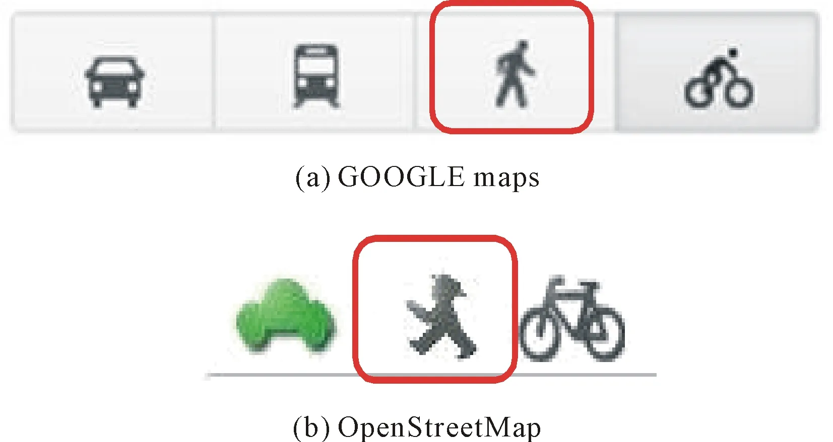
Fig. 1 Choice of pedestrian routing
Afterageneralresearchregardingrelatedwork,weconcentratedourresearchandthefollowingdesignofthesystemondirectcontactandinterviewswithwheelchairusers.Thisledustothedefinitionofthefollowingbarriers,whichcanbeaddedtothemapbytheusersinteractively:stairs,narrowpassages,ramps,andvariousinsurmountablesurfacing.Wehavedevelopedself-explanatoryiconsforallpotentialbarriers(Fig.2).
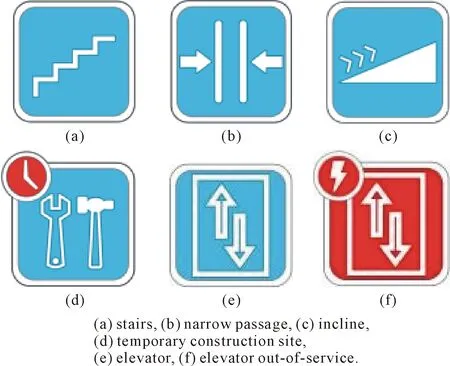
Fig. 2 Icons for barriers
Inadditiontostaticbarriers,userscanalsoaddtemporarybarriers(markedbyaredclocksymbol),suchasfallentreesortemporaryconstructionsites.Presently,thesetemporaryPOIsarebeingautomaticallyremovedfromthemapaftertwodays,unlessanotheruserrenewsitsexistence.
3Design
Weareusingthetrafficlightmetaphortomarktheselectedpathsaccordingtothefeatureofbeingpassableornot,i.e.whethertheyarebarrier-freeornot.Inourapp, “passable”iseitherdefinedbyastandardprofileorcanindividuallybedefinedbytheuser,ascertainbarriersmaycausedifficultiesforsomeusersbutnotothers;i.e.severalmembersinourtestinggroupwereabletoclimbstaircaseswithseveralstairs,whereasotherswouldnotbeabletomountlowsteps.Incasethepathisbarrier-free,itismarkedasagreenroutefromS(start)toZ(goal,German:Ziel) (Fig.3).Apathmarkedyellow(Fig.4,yellowroutemarkedwith“2”)containsbarriers,whichmaycausedifficultiesforcertainpeoplebutnotothers,i.e.theusercanindividuallydecidewhetherornots/hewantstoselectthatroute.Incasetheappdetectsabarrieralongtheshortestroute,thatroutewillbemarkedred(Fig.4,redroutemarkedwith“3”)andabarrier-free(green)alternative(Fig.4,greenroutemarkedwith“1”)willbecomputedautomatically.
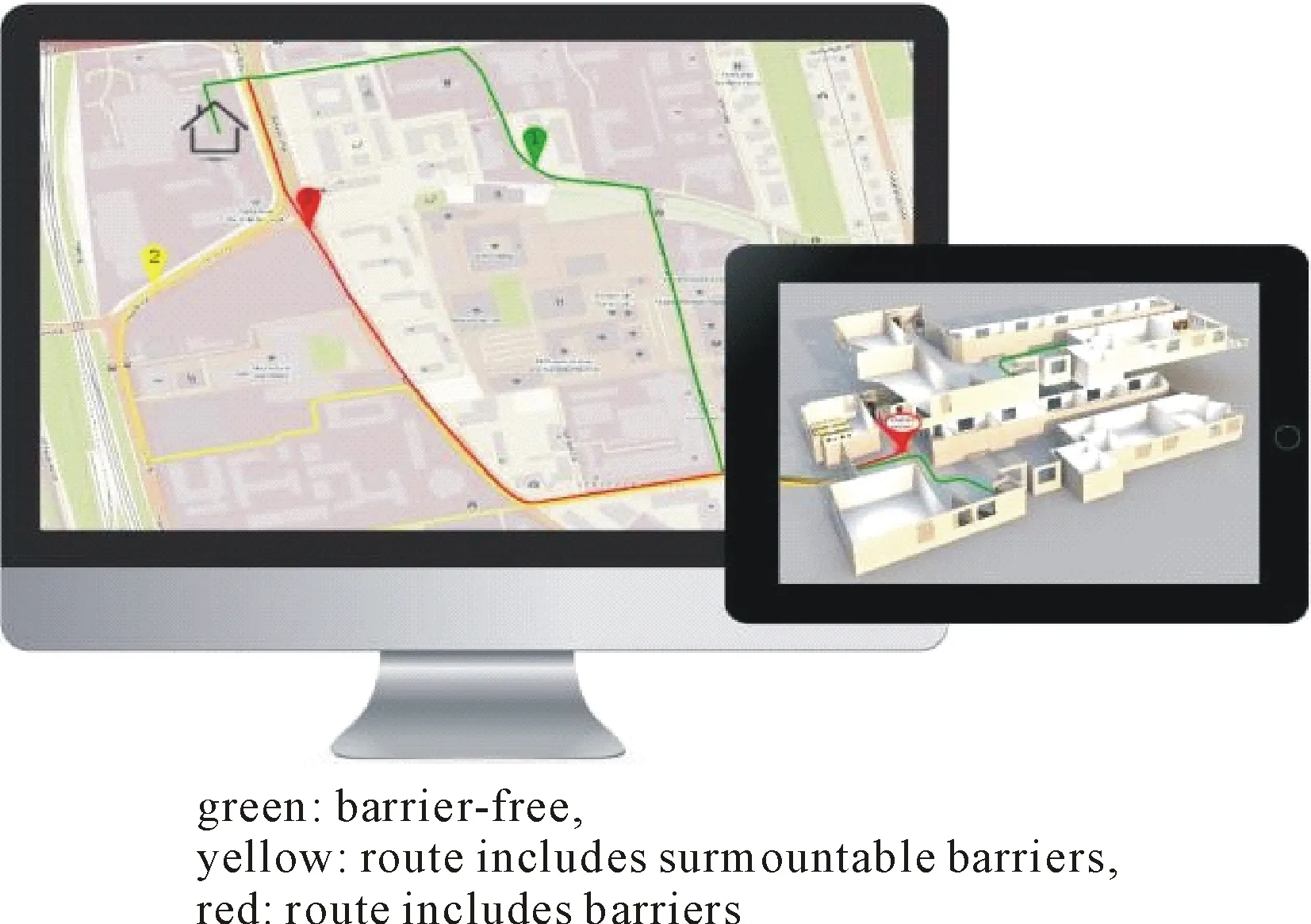
Fig. 3 Marking of routes
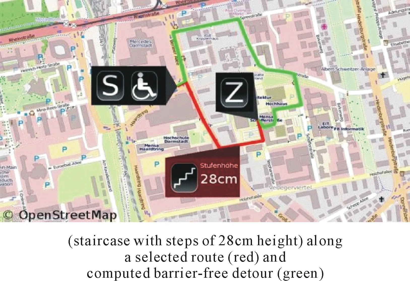
Fig. 4 Display of a barrier
Inallcases,theusercanalwaysselecttoviewthebarrieralongtherouteandwillbeshownthedetailsforthebarrier,whichincludestheicononthetypeofbarrierasfirstinformation,butinadditionalsotextwhichspecifiesthebarrier,suchasthenumberofstairsandtheheightofthestairs.Incaseaphotowasaddedforthebarrierbefore,theusercanalsochoosetoviewthatphoto.Allthisinformationhelpstodecidewhetherornotthebarriercanbesurmountedornot.
Thelook&feeloftheappisdesignedsoitcanbeusedwithoutmajorexplanationsandeachGUIisheldverysimplewithoutoverloadedfunctionalities.Theiconswedevelopedforthebarriersareself-explanatory(Fig.5).Mapsforoutdoornavigationareavailablefromdifferentsources,oneofthembeingOSM,whichwebaseouroutdoorroutingon.AsWheelScout+iscombiningoutdoorandindoornavigation,wefacedthechallengetocreateindoormapsforbuildings,asthesearehardlyavailableforuseinourapp.Wecreatedourownmapmaterialfortheindoornavigationonthebasisoftruetoscaleemergencyplans,whicharefreelyaccessibleineverypublicbuilding(Fig.6).
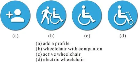
Fig. 5 self-explanatory icons for barriers
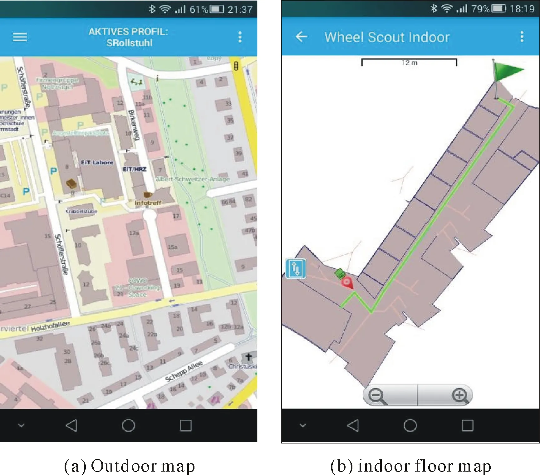
Fig. 6 maps based on emergency plan
4Functionalities
4.1Customization
Thetargetusersofourapparemobilityimpairedpeople,whoseabilitiestomastercertainroutesvarytremendously.Notonlydowheelchairsdifferinsize,butabilitiestomasterbarriersdifferamongusersandevendifferwithintheindividualaccordingtodailyconditions.Inordertoadjusttheapptoindividualneedsandlimitation,wehaveincludedthepossibilitytocustomizeoneormoreindividualprofilesbyincludinge.g.thesizeandtypeofthewheelchairandindividuallimitations,suchasthenumberofstairsthatcanbemastered.Foruserswhochoosenottodefinetheirindividualprofile,wehavepredefinedthreestandardprofiles(Fig.7),oneforactivewheelchairusers,thesecondoneforusersofelectricwheelchairs,andthethirdoneforwheelchairuserswhohaveanassistant
.
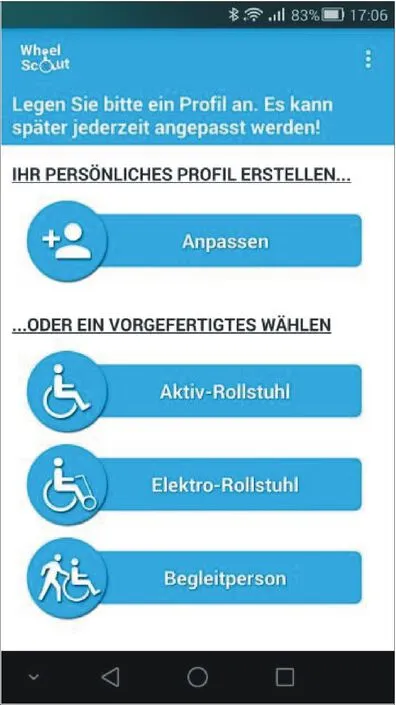
Fig. 7 Selection of an individual or
4.2TheMarkingofBarriers
Wedistinguishbetweentwotypesofbarriers:permanentandtemporarybarriers.Examplesforpermanentbarriersarestaircasesandramps,temporarybarrierscanbetemporaryconstructionsiteswhichmakeapassageunpassable,fallentreesorsurfaceconditionsduetotemporaryweatherconditions,e.g.icyroads.Onceatemporarybarrierisincludedintothemap,itwillbeautomaticallyremovedaftertwodays,unlessitisre-enteredbythesameoranotheruser.
(1)PermanentBarriers
Therearethreepossibilitiesforpermanentbarrierstoappearintheapp: (a)theyarepredefinedbyOSM, (b)weincludethemintotheOSMmapsbeforedistributionbyusingthePOIfeatureandcurrentGPSpositiontoincludea“pointofinterest”,i.e.oneofourbarriers,or(c)thesecondoptionisperformedbyoneofourusersinteractively,i.e.theappanditscorrectnessofbarrierswillgrowbyusingit.
(2)TemporaryBarriers
Therearetwopossibilitiesfortemporarybarrierstoappearintheapp: (a)theyareinteractivelyincludedbyuserswhentheyseeorexperienceatemporarybarrier,or(b)theyareincludedbytheroadtrafficlicensingdepartmentsofcitieswhichdecidetousetheappasameanstoreceiveanddistributedataabouttemporarybarriers.Temporarybarriersaremarkedbyaredclocksymbol(seeFig.2).
4.3Interactivity
Themarkingofbarriers,andthusthecorrectnessandcompletenessoftheapp,dependstoahighdegreeontheinteractivityoftheusers.Whenexperiencingorseeingapermanentortemporarybarrierthatisnotincludedintheappyet,theusercanincludeitbyspecifyingthetypeofbarrier,moredetailedinformationonthebarrier,ands/hecanoptionallytakeapictureofthebarrier,sofutureuserscandecideuponthepicturewhetherornotthebarrierwillcausedifficulties.
Afterthenewbarrierisaddedtotheapp,itspositionismarkedonthemapwiththecorrespondingicon.Uponselection(touchorroll-over)theadditionaltextualinformationisgiven,aswellasathumbnailimageofthebarrier,incaseapicturewaspreviouslyadded.Inthatcase,theimagecanbeenlarged.
4.4ChoiceofFrequentGoals
Inordertofacilitatethehandlingoftheapp,userscansaveseveralfrequentlyusedgoalsintheirnavigationmenu.Insteadofhavingtotypethelocationseachtime,theycansimplyclickonthelocation(seeFig.8forachoiceofindoorlocations),anditspositionandcoordinatesareautomaticallyincludedinthecalculationoftherouting.

Fig. 8 List of predefined indoor goals
4.5ComputationofIndividualand
Barrier-freeRoutes
ThebasisoftheoutdoorroutecomputationisprovidedbythefreenavigationtoolOSM,whichprovidesmapdataforlocationsworldwide.IndependentofWheel Scout’sfunctionalities,userscanuseOSMtocomputeanindividuallychosenroute,dependingontheirmeansoftransportation(e.g.bycar,bybicycle,byfoot).AsWheel Scoutuserswillneverchoosehighwaysorbigcountryroadswithoutfootpathsalongthesideastheirroutes,thoseareblockedinouralgorithm.WeuseOSM’sinformationonbarriersaswellasouraddedbarrierstocomputertheshortestpossiblepathforeachuserdependingonhisprofile.Incaseanunsurmountablebarrierisdetectedontheshortestpath,thatpathwillbemarkedred,thebarrierswillbedisplayedandabarrier-freedetourwillbecomputedandshownasagreenroute.Incasebarriersaredetectedwhichmaycausedifficulty,buttheusershoulddecidewhetherornottheycanbehandled,therouteswillbedisplayedinyellowcolorandthebarriersaredisplayedwithallinformationthatisavailableinourdatabase.
5Implementation&Technology
5.1HTML5
Inafirststep,westarteddevelopingtheappforAndroidplatforms,butsoonfoundthatthiswasanunacceptablelimitation,asthemobilemarketismuchtoodiverseandcurrentlydominatedbyatleast4 “keyplayers”:Androidphones,Apple’siPhoneswithiOS,RIM’sBlackberryandWindowsPhones.Andapartfromthemobilemarket,wealsowantedtoofferournavigationtooltouserswithoutsmartphonesandtothoseingeneralwhowanttocomputetheirroutesfromtheirhomes.Therefore,wehavechosentodevelopanHTML5websitewhichmakesitpossibletoinformuserswithoutsmartphonesaboutbarriersandtoplanroutesfromhome.Inaddition,itsavedusdevelopmenttime,whichwewouldhavehadtoinvestifwehadchosentodeveloptheappforallavailableplatformsnatively.ByhavingchosenHTML5,alluserscanaccessourapp,eveniftheirsmartphoneisnotnativelysupported,astheycanusethebrowseralternativeinstead.
5.2OpenStreetMap
WehavechosenOSMastheunderlyingmapforouroutdoorrouting,asitsinterfacesenableustoadddatatotheexistingmaps,i.e.ourbarriersas“pointsofinterest”,andwecanaccessitsdata,whichenablesustoextracttheinformationthatweneedtocomputeidealroutesforourindividualwheelchairuser.ThedatathatweextractfromOSMincludeswaysandtheirnodes,aswellasallbarriers,suchassteps,inclines,curbstonesandthenatureoftheground,suchassoilconditions.Allthesedataareneededtocheckwhichwaysandnodesexistandwhichonesarepassableaccordingtotheuser’sprofile.Thewaysandnodesincludefeature-valuepairs,calledtags.Examplesofsuchtagsare:
surface=cobblestone,surface=grass,smoothness=intermediate,incline=*,andwidth=*,includingthegradientoftheinclineinpercentorthewidthofapassageinmeters.
ThetagsareaccessedviatheOverpassAPI[8],whichreturnscustomselectedpartsoftheOSMmapdata.Itactsasadatabaseovertheweb:theclientsendsaquerytotheAPIandgetsbackthedatasetthatcorrespondstothequery.
AnXMLfileisbeingreturnedwhichisloadedbytheserverandusedinthenextprocessingstepinwhichthesinglenodesandwaysfromthefilearetranslatedintoJavaobjectswhichcontaintheIDoftheobjectsandtheirinformationaboutbarriersasakey-value-pattern.Anexampleforanentryforastaircasecouldbehighway=stepsandstep_count= 5for5steps.Whenausersendsaroutecomputationquery,thesedataarecomparedwiththeuser’sprofilebytheroutecomputationalgorithminordertocheckwhichwaysandnodesaresurmountableornot.
5.3GeneratingIndoorMaps
WecreateourownmapsfortheindoorroutingusingtheJavaOpenStreetMapEditor(JOSM)[9].Theinputtothetoolisatruetoscaleemergencyplanofabuildingfloor.ThetoolthengeneratesanXMLfilewherethedifferentbuildingparts,suchasroomsandexits,arerepresentedbydifferentXML-tags.Anexampleofamain-relationoftheindoormodelasOSM-XMLsourcecodeisprovidedinFig.9.

Fig. 9 XML source code of an indoor model
5.4GPS(outdoors)
Theentirecomputationoftheoutdoorroutes,thedetoursandthebarriersisbasedonGPSdatawhichisprovidedbyHTML5’sgeolocationfunctions,whichincludefunctionsforerrorhandling,theavailabilityofthelocationfunctions,andthequeryoftheposition.Whenthelatteriscalledfromthemobiledevice,thecurrentGPSdataissent.
Incasetheappisusedviaabrowser,thepositionisestimatedbymeansofthedevice’sIPaddressandthepossiblyexistingWLANsignal.IncaseswhereonlytheIPaddressisknown,theaccuracyofthepositionisnotveryexactandcanonlybeshownforageneralregion,e.g.metropolitanareaofacity,meaninganaccuracyofapproximately25~150km(Fig.10).
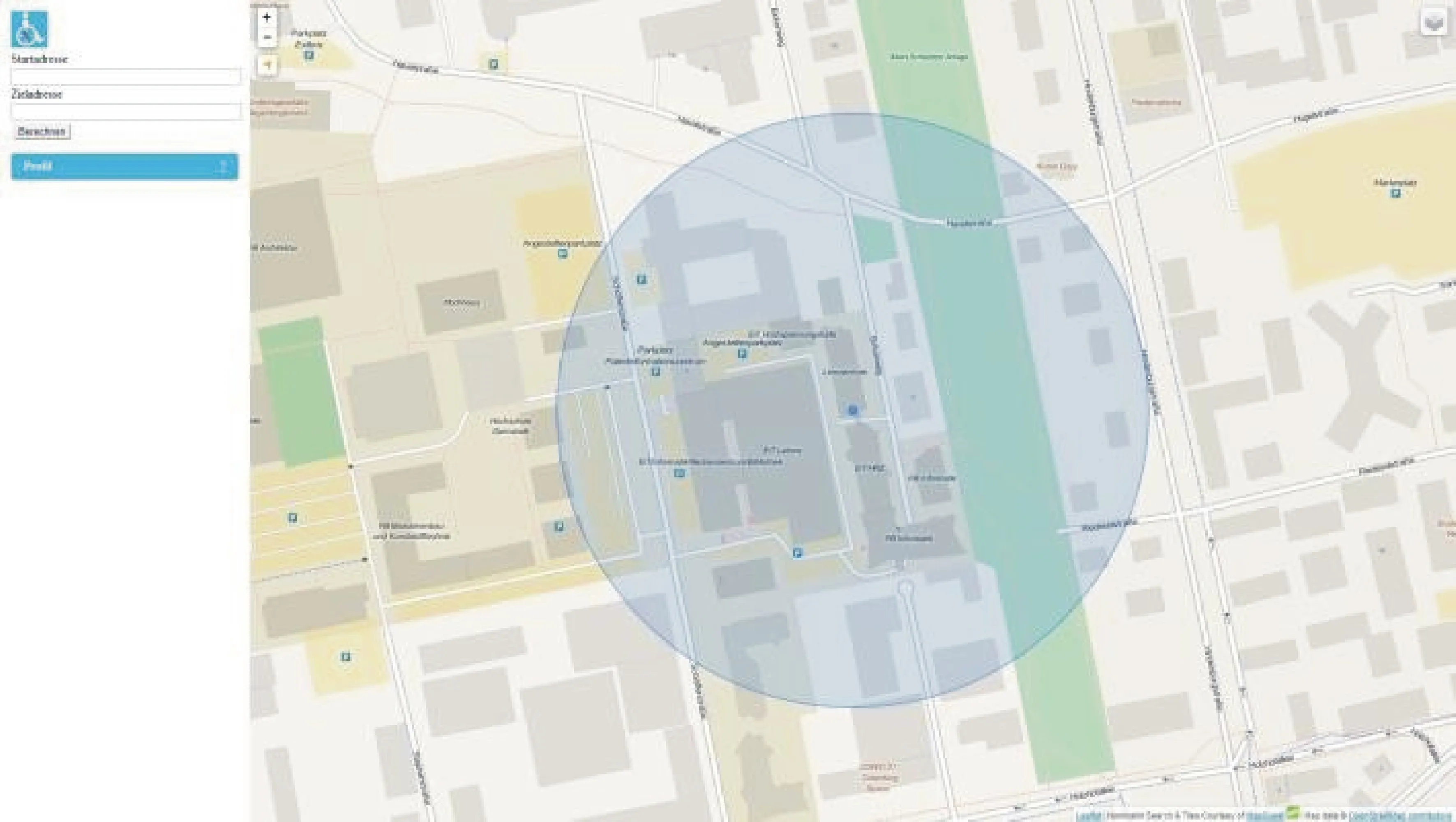
Fig. 10 Marking of the position based on the IP address only
IncaseswherewehaveaWLANsignalknownbyGoogle,anaccuracyofapproximately0.5mistheoreticallypossible.Ourexperienceandtestshaveshownthattheaccuracyinalargecityisusuallybetween30and75m.ButbecauseweonlyneedtoaccessthesepossibilitieswhennoGPSsignalisavailable,thisscenarioislimitedtostationarycomputersinresidentialhomes.Inthesecasesavaguepositioningdoesn’tcauseproblems,astheuserdoesn’tneedtofindorlocatehispositiononamap,asheknowswherehelives,butit’sratherusedtosimplifytheuseofthemap.
Whenusingtheweb-versionofWheel Scout,thebrowserwillaskforpermission,eachtimethepositionisbeingcomputed.Withthemobileversionthisstephappensautomatically,astheappwillbepermanentlyauthorizedtoaccesstheGPSfunctionupondownload.
5.5GeoPosition(indoors)
Forindoortracking,wecouldn’tusethesameGPStechnologythatweusedforouroutdoorrouting,asGPSsignalscannotalwaysbereceivedinsideofabuilding.Instead,weuseBluetoothtransmitters,whichbroadcasttheirUUID,inwhichtheGeopositionofthetransmitterisencoded.TheapplicationusesthethreenearestBluetoothtransmittersandbymeansoftrilateration(Fig. 11)thepositionoftheuserisbeingcalculated.Forreasonsofmaximalpreciseness,thistrilaterationcalculationisperformedmultipletimeseverysecond,sothatanaveragevalue,whichrepresentsthepositionoftheuser,canbecalculated.
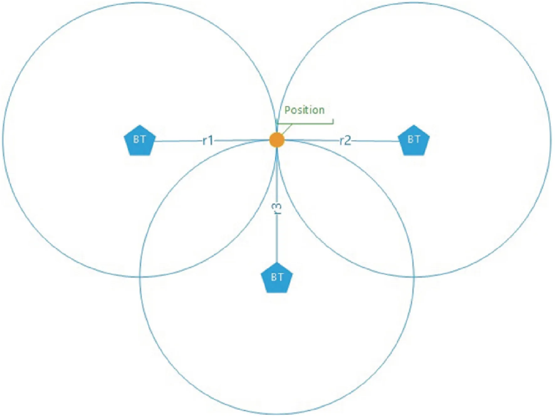
Fig. 11 Calculation of indoor positioning via trilateration
Theaimwastocreateaconnectionbetweentheindoormap,whichisdependingonrealcoordinatesandtheBluetoothtransmitters,whichareplacedinsidetheindoormap.ThereasonforthisisthepossibilitytocalculateGPSgeographicalcoordinatesinsideabuildingwithnoGPSsignal.Thismakesiteasytorealizeafluenttrackingwhilemovingfromtheoutsidetotheinsideofabuilding.
5.6IndoorRouting
Therouteofournavigationiscalculatedonaserver.Forourindoorroutingweusedirectedweightedmultigraphsforeverybuildingasabasisfortherouting.Thegraphsusethedistanceinkilometers(valueoftypeDouble)asweightfortheedges.Thisdistanceiscalculatedfromthegeo-coordinatesofthestart-andend-pointoftheedge.Thegraphneedstobedirectedbecauseinbuildingstherearesomepathsthatmaynotbeaccessedinbothways,likeescalatorsorexits.Thegraphneedstobeamultigraphinordertobeabletosettwoedgesbetweentwovertices,toallowroutinginbothdirections.
TheRoutingHandler[10]readsprofileinformationfromtheroutingrequestandwillthenbuildasubgraphbasedonthedefinedrestrictions.Thesubgraphwillnotcontainpathsthatareinaccessiblefortheuser.
Routingcanonlybedonebetweentwoverticesthatarepartofthegraph,sooneneededstepbeforetheroutingistofindtwoverticesthatareclosetothedesiredstartandendpoint.Forthatreasonasearchonallverticesisdoneandthetwoclosestaredetermined(Fig.12).
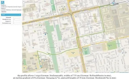
Fig. 12 Computing and drawing a route based on a profile
5.7Computationofroutesandbarrierhandling
Themostprominentfeatureofourappisthehandlingofbarriersandtheresultingcomputationanddrawingofabarrier-freeroute.Inordertocheckwhetherthechosenroutecontainsbarriers,wecomparethelistoftagsandvalueswhichexistforeachnodeandwaywiththeindividualprofileoftheuser(shownontheleftofFig.12).Thiswilltelluswhethertherouteispassableandbarrier-free(drawnasagreenroute)ornot.
WeareusingtheDijkstra-algorithm[11]tocomputetheoptimalrouteforourusers.Thisalgorithmcomputestheshortestpathforagivenstart-nodeandone(ormore)target-nodes,inourcasethegoalorlocationtheuserwantstotravelto.InOSMandourdatabaseanintersectioniscallednodeandastreetorpathiscalledway.
First,thestart-andtarget-nodesaredeterminedbyselectingthenodesfromourdatabasewhichareclosesttotheselectedstart-andtarget-nodes.Startingfromthese(database)nodes,thealgorithmwillcheckforthenextnearestnodes.Thesewillbeconnectedbyways.Incasetheconnectingwayisimpassableforwheelchairusersduetobarriers,thisnodewillbeignored.Forallnodesthatcanbereachedonabarrier-freeway,thedistancebetweenthenodeswillbecomputedandstoredforfurthercomputation.
Oncethedistancesbetweenthestartnodeandallreachablenodesarestoredinthereachablenodes,thestartnodewillbemarkedoffas“visited”andwillbeignoreduntilthegoalnodeisreached.Thefollowingstepswillthenbeprocessedinthisorder:
step1Lookforthenodewiththeshortestdistanceandwhichhasn’tbeenvisitedyet.
step2Computethedistancestoallreachablenodesandrecordthedistanceincasenovaluehasbeenenteredyetorthedistanceisshorterthanthepreviousvalue.
step3Returntostep1.untilthenodewiththelowestvalueandwhichhasn’tbeenvisitedyet,isthetarget-node.
Thisprocesswillberepeatedtwiceinordertocomputeagreenandayelloworredpath.Afterfirsttryingtofindagreenpath,theprocesswillberepeatedforayelloworredroute.Theyellowroutewillincludetheuser’sprofiledataforyellowroutes,i.e.barriers,whicharesurmountableforsomeusersorundercertaincircumstances.Incasebarriersaredetectedalongthechosenroute,theywillbebufferedinthedataforthatrouteinordertoberetrievedandincludedintheapplateruponrequestoftheuser.Atthatstage,theusercandecideindividually,whetherthebarriersaresurmountableforhimornot.Whencomputinganddrawingaredroutewedonotincludeprofiledata,asthoseroutesarenotsurmountableunderanycircumstancesandtheappwillalwaysdrawtheshortestroute.
Dependingontheresultofthiscomputationprocess,thefunctionpathdraw(Fig.13)willdrawthecomputedrouteintheappropriatecolor.
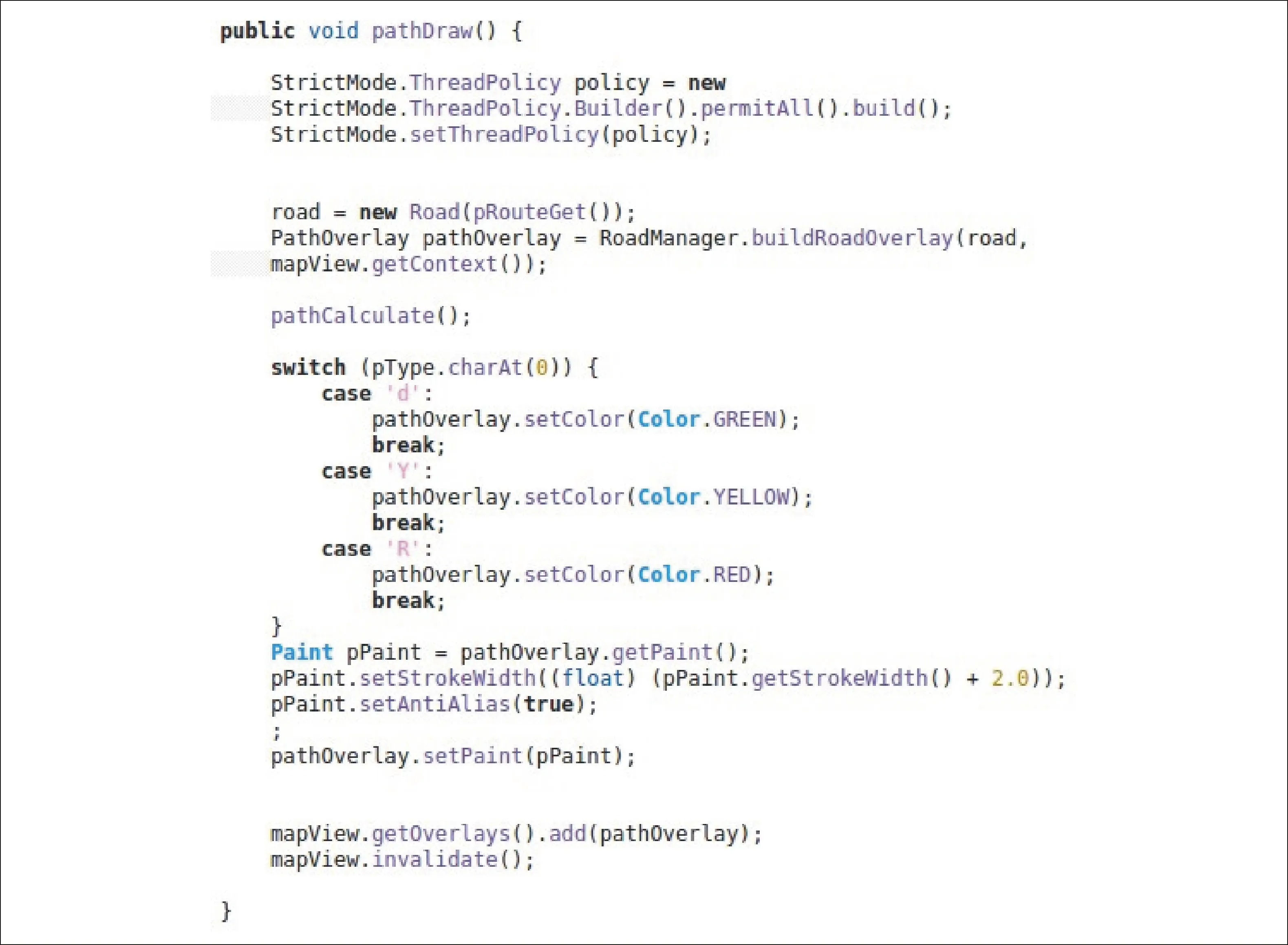
Fig. 13 Pathdraw function drawing routes in different colors according to
6Conclusion
Inordertosupportmobilityimpairedpeopleintheirrouting,wehaveinitiallydevelopedtheprototypicalapplicationWheel ScoutforoutdoorroutingonthebasisofthegeographicaldataofOpenStreetMapwhichenablesuserstonavigatefromAtoBonabarrier-freeroute.Inadditiontocommonlyknownfeaturesofnavigationsystems,weareusingthepointsofinterestfeatureandtheirgeodatasettointeractivelyaddbarrierstothemaps.Afterverypromisingfeedbackforourtestusers,weaddedindoorroutingtotheappinordertoallowuserstoincludeindoorstartingorendingpointsintheirroutes,byenhancingtheoriginalWheelScoutappbyRSSIbasedBluetoothLowEnergyIndoorPositioningusinggeographicalcoordinatescallingthenewappWheel Scout Indoor.Besidesasimpleandlow-costestablishmentofaBluetoothwirelesssensornetwork,anotheradvantageofoursolutionisthelongrangeofthetransmissionpower,whichcanbeadjustedsothatawiderangeindoorpositioningispossible.Weareusinggeolocationsforthetrackingofpositionsandtherouting.Thatwaywearenotonlyindependentofspecialcoordinatesystemsfordifferentbuildings,butournavigationassistanceworksindoorsaswellasoutdoors,asoutdoorroutingisbasedonthesamegeoiddata.
Reference
[1]OpenStreetMap[CM/OL].[2015-11-20].http://www.openstreetmap.org.
[2]TomTomNavigationSystem[CM/OL].[2015-11-20].http://www.routes.tomtom.com.
[3]GarminStreetnavigation[CM/OL].[2015-11-20].http://www.garmin.com/de-DE/explore/ontheroad.
[4]GoogleMaps[CM/OL].[2015-11-20].http://www.google.de/mobile/maps.
[5]Wheelmap[CM/OL].[2015-11-20].WheelmapProject.http://wheelmap.org.
[6]DepartmentofGeoinformatics,UniversityofHeidelberg.RollstuhlroutingProject[CM/OL].[2015-11-20].http://www.rollstuhlrouting.de
[7]MENKENSC,SUSSMANNJ,AL-ALIM.et.al.EasyWheel:AMobileSocialNavigationandSupportSystemforWheelchairUsers[C/OL]//2011EighthInternationalConferenceonInformationTechnology:NewGenerations(ITNG).LasVegas,NevadaUSA:IEEE, 2011:859-866[2015-11-20].http://dx.doi.org/10.1109/ITNG.2011.149.
[8]OverpassAPI[EB/OL].[2015-11-20].http://overpass-api.de.
[9]JOSM.JavaOpenStreetMapEditor[EB/OL].[2015-11-20].https://josm.openstreetmap.de.
[10]JGraphTDirectWeightedMultigraph[EB/OL].[2015-11-20].http://jgrapht.org/javadoc/org/jgrapht/graph/DirectedWeightedMultigraph.html.
[11]MORRISJ.DataStructuresandAlgorithms:Dijkstra’sAlgorithm[EB/OL].[2015-11-20].https://www.cs.auckland.ac.nz/software/AlgAnim/dijkstra.html.
[editedby:RayKing]
輪椅偵察:移動受限用戶的戶內外導航系統
貝蒂娜·哈利豪斯-謬赫鮑爾
(應用科技大學 計算機科學系, 德國 達姆斯達特市 D-64295)
摘要:為幫助移動受限人群找到無障礙的室內外路線,開發一款稱為“輪椅偵察”的移動應用程序,基于個人資料,計算兩個位置間的無障礙路線。“輪椅偵察”導航輔助系統包括:(a)在選擇的路線上標記障礙;(b)當選定的路線上有障礙的情況下智能計算出一個迂回路線;(c)通過定義個人資料定制應用程序;(d)即包含固定障礙也包含臨時障礙;(e) 高度的互動性增強了應用程序穩定性。除了那些被導航系統普遍采用的特性,興趣點(POI)特性及其地理數據集被用以在地圖中添加障礙物。在藍牙發射器發送的信號中納入地理位置信息,并通過對信號強度的三邊測量,以確保“輪椅偵察”室內導航輔助系統可對室內用戶完成實時準確地定位。路徑終點由用戶單獨選擇,也反映為地理位置。地理位置采用十進制格式,方便將計算結果顯示在每個數字地圖中。改變為每棟建筑設置特殊坐標系統的做法,使用統一的全球坐標系統描述地理位置,如此以來,導航輔助系統不僅可以擺脫對額外坐標信息的依賴,還能像在室內那樣很好地應用于室外,因為,室外路徑也基于相同的坐標系統。所給系統的新意在于,即使不使用衛星通信定位,仍可實現用戶跟蹤。
關鍵詞:移動導航;無障礙人行道計算;移動插入障礙;藍牙室內定位
doi:10.13682/j.issn.2095-6533.2016.03.002
Document Code:CLC Nubmer: TP391 A Article ID: 2095-6533(2016)03-0015-10
Received on:2016-01-10
Supported by:Centre for Research & Development, University of Applied Sciences, Darmstadt and Association of Invalids, Southern Tirol, Italy
Contributed by:Bettina Harriehausen-Mühlbauer(1960-),PhD, professor, engaged in mobile applications for mobility impaired people and natural language processing. E-mail: bettina.harriehausen@h-da.de