哈密水土利用遙感監測成果移動應用APP設計與實現
2018-09-10 03:47:47馬曉兵沈林申源
河南科技
2018年7期
馬曉兵 沈林 申源
摘 要:新疆地域廣袤,自然條件惡劣,水利業務人員在野外開展現場核查及執法工作時,水土利用遙感監測成果急需一種高效便捷的移動應用方式,供業務人員快速準確地確定現場空間位置及與監測對象的空間位置關系,查詢瀏覽水土利用對象信息。基于此,本設計研發了一款哈密水土利用遙感監測成果移動應用及巡查導航APP。該APP利用當下流行普及的Android移動智能設備,易用性強,穩定性高,被廣泛應用于各個領域。
關鍵詞:Android;LBS;水土利用;遙感監測
中圖分類號:P208 文獻標識碼:A 文章編號:1003-5168(2018)07-0026-03
Research on Water Conservancy Application Based
on Virtual Reality and GIS Technology
MA Xiaobing SHEN Lin SHEN Yuan
(Information Center of the Yellow River Water Conservancy Commission,Zhengzhou Henan 450003)
Abstract: The area of Xinjiang is vast and the natural conditions are bad. When the water conservancy personnel carry out field verification and law enforcement in the field, the results of remote sensing monitoring of soil and water use urgently need a kind of efficient and convenient mobile application way, for the business personnel to quickly and accurately determine the location of the field space and the relationship between the monitoring of the spatial location of the image and the inquiry of the browsing water. The information of soil utilization objects. Based on this, we designed and developed a mobile application and patrol navigation APP for remote sensing monitoring of soil and water use in Hami. The APP took advantage of the popular Android mobile intelligent device, which was easy to use and has high stability. It has been widely used in various fields.
Keywords: Android;LBS;soil and water use;remote sensing monitoring
1 哈密水土利用遙感監測成果移動應用APP研發背景和意義
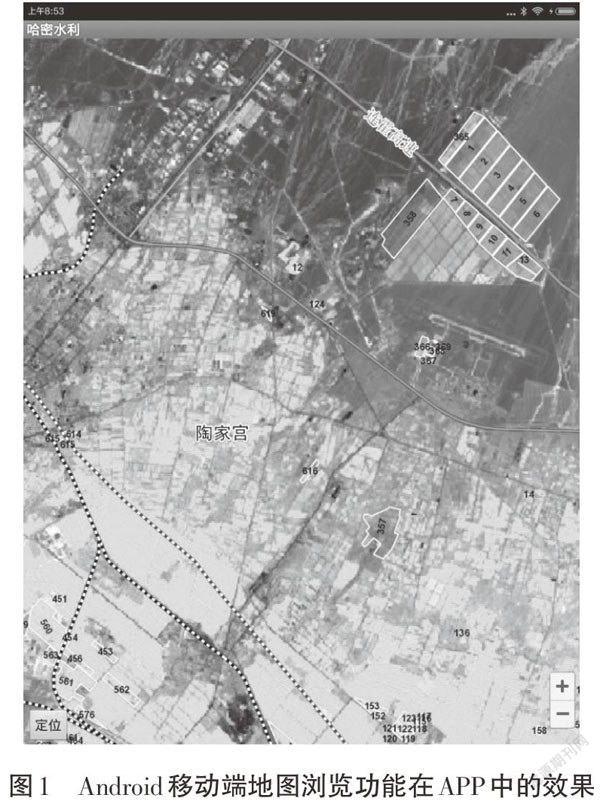
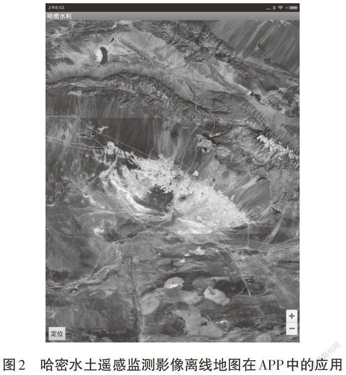
哈密地區屬水資源匱乏地區,用水矛盾較為突出。隨著地區經濟尤其是新型工業化的快速發展,落實“土地零開荒”政策,對合理配置和利用水資源、改善區域生態環境、促進區域經濟社會快速發展具有重要意義。遙感技術作為一種綜合性信息獲取技術,隨著遙感數據資源愈加豐富,初步達到了應用產業化、遙感信息定量化水平。利用高分辨率衛星遙感技術,對哈密地區水土利用情況進行調查監測,獲取哈密水土利用成果,開發基于PC端桌面的監測信息系統,為區域水土資源開發利用、分析研究、有效管理等工作提供科學依據,但桌面版成果信息系統僅限于業務人員室內作業時使用[1]。
新疆地域廣袤,自然條件惡劣,水利業務人員在野外開展現場核查及執法工作時,水土利用遙感監測成果急需一種高效便捷的移動應用方式,供業務人員快速準確地確定現場空間位置及與監測對象的空間位置關系,查詢瀏覽水土利用對象信息。……
登錄APP查看全文