基于深度學習的高分辨率遙感圖像海陸分割方法
2020-05-28 09:36:21崔昊
軟件導刊 2020年3期
關鍵詞:深度學習
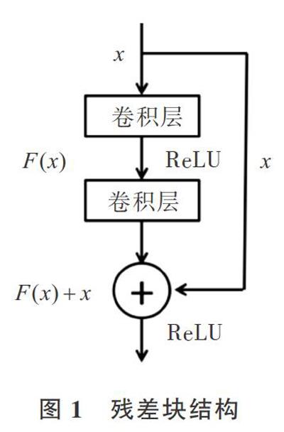

摘 要:將高分辨率遙感圖像進行像素級海陸分割是遙感應用領域的一項基礎性工作,對海岸線提取和海洋近岸目標檢測具有重要意義,但傳統閾值方法往往由于高分辨率遙感圖像覆蓋范圍廣、地物紋理復雜等特點而難以取得預期效果。為了提升高分辨率遙感影像海陸分割精度,改善傳統閾值方法的不足,基于深度神經網絡模型利用編碼器—解碼器架構,并在編碼層中引入殘差塊,以更好地對特征圖進行高級語義信息提取,通過解碼層將編碼層生成的特征圖還原成與輸入尺寸相同的特征圖,最后通過Sigmoid層對圖像進行像素級海陸分割。在高分辨率遙感圖像數據集上的實驗結果表明,該網絡模型取得良好了分割效果,準確率和Kappa系數分別達到了94.3%和93.7%。與傳統方法相比,海陸分割精確度得到了有效提升。
關鍵詞:深度學習;高分辨率遙感圖像;海陸分割;深度神經網絡;編碼—解碼架構
DOI:10. 11907/rjdk. 192771
中圖分類號:TP301 ? 文獻標識碼:A??????????????? 文章編號:1672-7800(2020)003-0095-04
Land and Sea Segmentation Method of High-Resolution Remote Sensing Image Based on Deep Learning
CUI Hao
(School of Computer Science & Engineering,Shandong University of Science & Technology,Qingdao 266590,China)
Abstract: Pixel-level sea-land segmentation of high-resolution remote-sensing images is a basic work in remote sensing applications. It is of great significance for coastline extraction and marine near-shore target detection. However, However, the traditional threshold method is often difficult to obtain the expected results due to the wide coverage of high-resolution remote sensing images and the complex texture of the ground features. In order to improve the accuracy of sea land segmentation of high-resolution remote sensing image and improve the shortcomings of traditional threshold methods, based on the depth neural network model, the encoder decoder architecture is used, and residual blocks are introduced into the coding layer to better extract the high-level semantic information of the feature map. Through the decoding layer, the feature map generated by the coding layer is restored to the feature map with the same size as the input. Finally through the Sigmoid layer, the sea land segmentation of images is made at the pixel level. The experimental results on the high-resolution remote sensing image dataset show that the network model achieves good segmentation results, and the accuracy rate and Kappa coefficient reach 94.3% and 93.7%, respectively. Compared with the existing traditional methods, this method improves the accuracy of land and sea segmentation.
Key Words: deep learning;high-resolution remote sensing image;sea and land segmentation;deep neural network; encoding-decoding architecture
0 引言
近年來,隨著我國遙感衛星技術的快速發展,高分辨率遙感圖像在海洋開發應用與權益保護監督等方面獲得廣泛應用。高分辨率遙感圖像具有覆蓋范圍廣、地物紋理信息豐富、成像光譜波段多、重訪時間短等多種特征。高分辨率遙感圖像解譯也是數字圖像分析的重要組成部分,已廣泛應用于土地測繪、環境監測、城市建設等領域。其中,語義分割在遙感圖像解譯中扮演重要角色,是低高層遙感圖像處理及分析的重要銜接[1]。對高分辨率遙感圖像進行海陸分割的目的是將遙感近岸圖像準確地分割成海洋和陸地區域。提升高分辨率遙感圖像海陸分割精確度,有利于對近海區域目標進行檢測,并且獲取的海岸線等信息對海岸演化分析[2] 、潮間帶性質和分布信息提取[3]等具有重要意義。
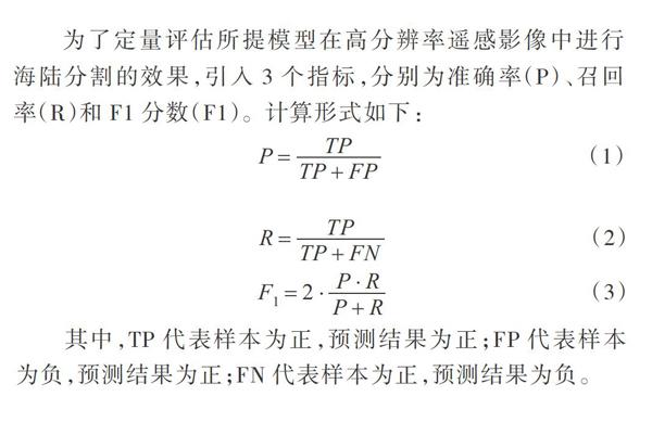
2.3 實驗評價
為了定量評估所提模型在高分辨率遙感影像中進行海陸分割的效果,引入3個指標,分別為準確率(P)、召回率(R)和F1分數(F1)。計算形式如下:
其中,TP代表樣本為正,預測結果為正;FP代表樣本為負,預測結果為正;FN代表樣本為正,預測結果為負。
2.4 實驗結果分析
為了驗證本文構建的深度學習模型在高分辨率遙感圖像海陸分割任務中的有效性,將實驗結果與傳統LATM方法以及圖像語義分割領域經典的深度學習網絡模型FCN、PSPNet進行高分辨率遙感圖像海陸分割效果對比,實驗中使用相同的訓練樣本和驗證樣本,結果如圖3、表1所示。
由圖3可知,傳統方法LATM對于紋理和強度變化復雜的高分辨率遙感圖像,不僅容易對陸地地物進行錯誤分類,而且在海陸分割處呈現明顯不規則性,分割效果較差;FCN網絡更容易對土地像素進行錯誤分類;海陸分割在PSPNet得到了較好結果,但仍然在港口處存著錯誤分類。與這些方法相比,本文方法(Ours)可以獲得更一致的空間結果,海陸分割效果最好。
由表1可知,傳統方法LATM和FCN網絡對高分辨率遙感圖像海陸分割能力相對較弱,PSPNet能取得較好結果,本文網絡模型在測試數據集上各項指標均表現出最優結果。
3 結語
為了更好地實現高分辨率遙感圖像海陸分割,本文利用編碼器—解碼器架構,在編碼層中引入殘差塊構建了一個新型網絡,實現了高分辨率遙感圖像端到端的海陸分類。為了驗證網絡架構的有效性,手動標記高分辨率遙感圖像真值圖,并在此數據集上與PSPNet等方法進行比較。 實驗結果表明,本文提出的網絡結構取得了最好結果。但其海陸分割結果精度還有待進一步提升,尤其是海陸交界邊緣部分,仍有一定誤差,整個網絡模型尚有改進空間。未來將重點對架構進行優化,以進一步提高分割準確性。
參考文獻:
[1]蘇健民,楊嵐心,景維鵬. 基于U-Net的高分辨率遙感圖像語義分割方法[J]. 計算機工程與應用,2019,55(7):207-213.
[2]ZHANG S P,ZHANG C T.Image analysis for wave swash using color feature extraction[C]. Proceedings of the 2nd International Congress on Image and Signal Processing (CISP),2009:1-4.
[3]QIN P.Waterline information extraction from radial sand ridge of south Yellow Sea[C]. Proceedings of the 6th International Congresson Imageand Signal Processing(CISP),2013:459:463.
[4]LIU H,JEZEK K C.Automated extraction of coastline from satellite imagery by integrating canny edge detection and locally adaptive thresholding methods[J]. International Journal of Remote Sensing,2004,25(5):037-958.
[5]ZHANG H W,ZHANG B M,GUO H T, etal.An automatic coastline extraction method based on active contour model[C]. Proceedings of the 21st International Conference on Geoinformatics,2013:111-115.
[6]NIEDERMEIER A,ROMANEESSEN E,LEHNER S.Detection of coastlines in SAR images using wavelet methods [J]. IEEE Transactions on Geoscience and Remote Sensing,2000,38(5):2270-2281.
[7]吳一全,劉忠林. 遙感影像的海岸線自動提取方法研究進展[J]. 遙感學報,2019,23(4):582-602.
[8]MCFEETERS S K.The use of the normalized difference water index (NDWI) in the delineation of open water features[J].? International Journal of Remote Sensing,1996,17(7):1425-1432.
[9]LIU G,ET AL.A new method on inshore ship detection in high-resolution satellite images using shape and context information[J]. Geoscience and Remote Letter,IEEE,2014.11(3):617-621.
[10]CAI S,WU H M.Study on change detection of ship target based on sea-land segmentation[J]. Video Engineering,2010,34(5):109 -112.
[11]LIU H, JEZEK K C.Automated extraction of coastline from satellite imagery by integrating Canny edge detection and locally adaptive thresholding methods[J]. International Journal of Remote Sensing,2004,25(5):937-958.
[12]HU F,XIA G S,HU J W,et al.Transferring deep convolutional neural networks for the scene classification of high-resolution remote sensing imagery[J]. Remote Sensing,2015,7(11):14680-14707.
[13]LONG J,SHELHAMER E,DARRELL T.Fully convolutional networks for semantic segmentation[J]. IEEE Transactions on Pattern Analysis & Machine Intelligence,2014,39(4):640-651.
[14]RONNEBERGER O,FISCHER P,BROX T.U-Net:Convolutional networks for biomedical image segmentation[J]. Medical Image Computing and Computer-Assisted Intervention(MICCAI),2015,9351:234-241.
[15]BADRINARAYANAN V,KENDALL A,CIPOLLA R. SegNet:a deep convolutional encoder-decoder architecture for scene segmentation[J]. IEEE Transactions on Pattern Analysis and Machine Intelligence,2017,39(12):2481-2495.
[16]ZHAO H,SHI J,QI X,et al. Pyramid scene parsing net-work[DB/OL]. https://arxiv.org/abs/1612.01105,2016.
(責任編輯:孫 娟)
收稿日期:2020-01-03
作者簡介:崔昊(1993-),男,山東科技大學計算機科學與工程學院碩士研究生,研究方向為智能信息處理、機器學習。本文通訊作者:崔昊。
猜你喜歡
中國教育技術裝備(2016年19期)2016-12-27 19:23:52
中國遠程教育(2016年11期)2016-12-27 18:07:31
現代商貿工業(2016年25期)2016-12-26 09:58:02
江蘇教育·中學教學版(2016年11期)2016-12-21 11:45:08
江蘇教育·中學教學版(2016年11期)2016-12-21 11:36:29
現代情報(2016年10期)2016-12-15 11:50:53
考試周刊(2016年94期)2016-12-12 12:15:04
新教育時代·教師版(2016年23期)2016-12-06 06:02:38
法制與社會(2016年32期)2016-12-01 15:25:53
軟件導刊(2016年9期)2016-11-07 22:20:49