大氣層內載體星光折射間接敏感地平定位可行性分析
2022-03-04 08:27:16詹先軍王新龍胡曉東丁小昆
航空兵器 2022年1期
詹先軍 王新龍 胡曉東 丁小昆
摘 要:星光折射間接敏感地平定位方法具有自主性強、精度高、成本低等特點,是一種很有應用前景的新型天文導航方法。 目前,傳統的星光折射間接敏感地平定位方法是以大氣層外載體為應用對象而提出的一種天文定位方法,然而絕大部分載體主要工作在大氣層內,為了分析這種星光折射間接敏感地平定位方法應用于大氣層內載體的可行性,本文首先基于折射定律和球形大氣模型建立了星光大氣折射模型,分析了根據星光折射角與載體位置之間的關系進行星光折射間接敏感地平定位的工作機理,進而通過定量分析載體在大氣層內、外觀測的折射角偏差,對星光折射間接敏感地平定位方法在大氣層內應用的可行性進行論證與分析。 結果表明,傳統星光折射間接敏感地平定位方法只適用于在40 km以上至大氣層外飛行的載體,若能利用高度計獲得載體的粗略高度,可以將星光折射間接敏感地平定位方法應用于大氣層內飛行高度在20~40 km的飛行載體。
關鍵詞:天文導航;星光折射導航;間接敏感地平定位;星光大氣折射;折射角;數學模型
中圖分類號:TJ765;V249.32+3? 文獻標識碼:?? A文章編號:1673-5048(2022)01-0107-06[SQ0]
0 引? 言
星光折射間接敏感地平定位方法是20世紀80年代發展起來的一種高精度、低成本的天文導航方法[1-3],該方法利用星敏感器觀測經地球大氣發生折射的恒星星光,根據星光大氣折射模型,將星光折射角轉化為與載體位置相關的折射視高度信息,進而解算得到載體精確的位置信息。 1989年,美國利用多任務姿態確定和自主導航系統(MADAN)進行了星光折射間接敏感地平定位的空間實驗。 研究表明,這種天文定位方法自主性好、成本低廉,能夠達到較高的定位精度[4],具有廣闊的應用前景。
與國外相比,國內在星光折射間接敏感地平定位技術領域的研究起步略晚,但發展較快。 目前,國內學者已從星光折射定位方法[5]、星光大氣折射模型[6]、影響導航性能的因素[7]等方面對星光折射間接敏感地平定位技術開展了研究,但主要集中在地球衛星[8]、彈道導彈[9]、航天器[10]等大氣層外飛行載體。 而在大氣層內,飛機、臨近空間飛行器等載體對高精度自主導航方法的需求日益迫切,如果將星光折射間接敏感地平定位方法應用在大氣層內飛行器上,可以大幅提高飛行器的導航精度和可靠性。
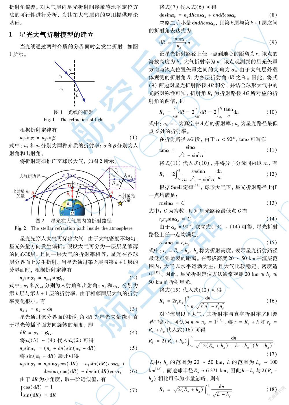
傳統星光大氣折射模型描述了星光從穿入大氣到穿出大氣所對應的折射角與折射高度之間的關系。 而載體在大氣層內時,由于星光穿入大氣后未穿出大氣就到達載體,載體上觀測的折射角就不再是原來的折射角,使傳統星光大氣折射模型不再適用,給星光折射間接敏感地平定位方法在大氣層內的應用帶來新的問題。
因此,本文從折射定律和球形大氣模型出發,建立星光在大氣中折射的數學模型,并揭示了星光折射角與載體位置之間的關系以及星光折射間接敏感地平定位的原理。 在此基礎上,通過推導載體在大氣層內、外觀測的折射角偏差, 對大氣層內星光折射間接敏感地平定位方法的可行性進行分析,為其在大氣層內的應用提供理論基礎。
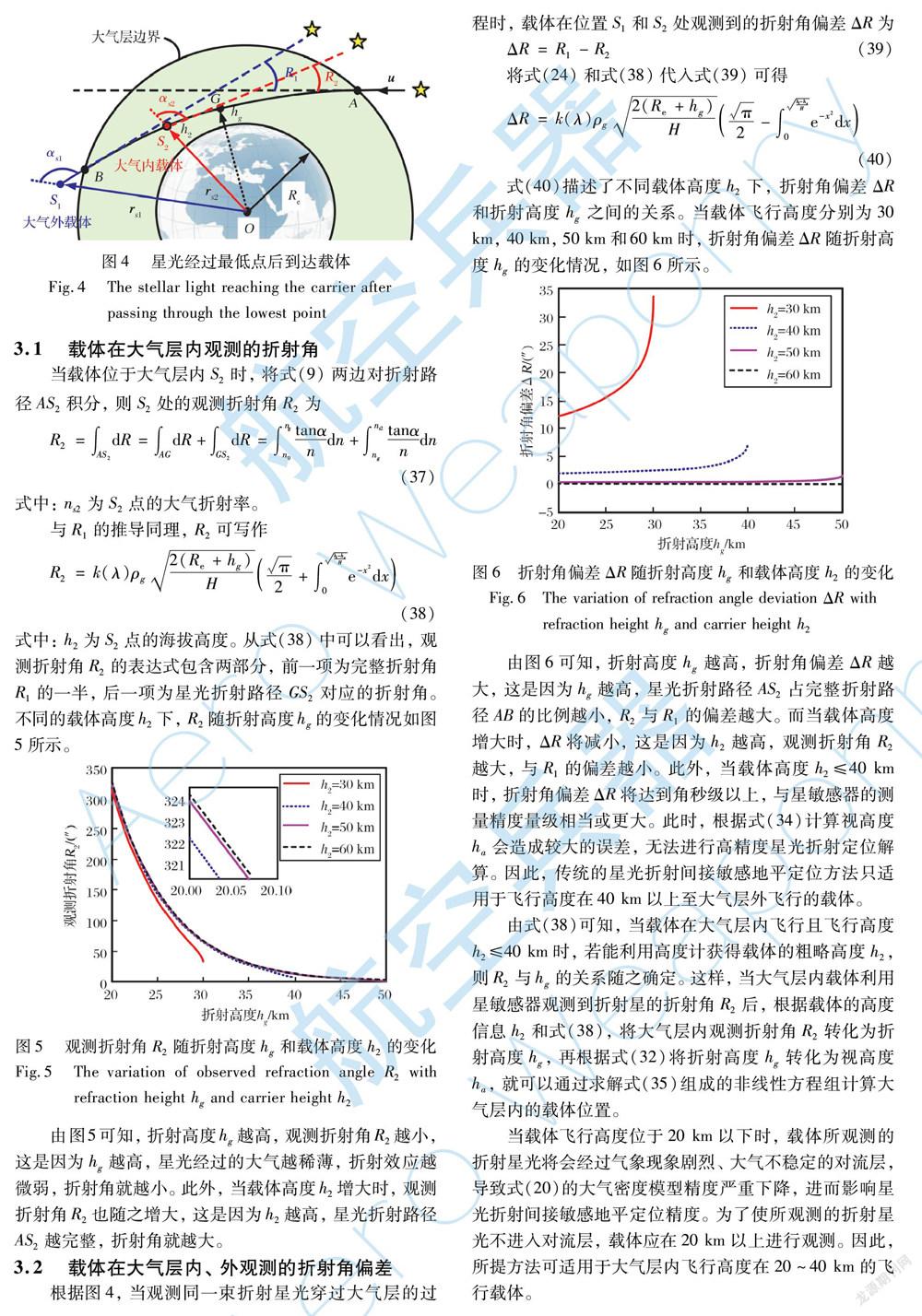
由圖6可知,折射高度hg越高,折射角偏差ΔR越大,這是因為hg越高,星光折射路徑AS2占完整折射路徑AB的比例越小,R2與R1的偏差越大。 而當載體高度增大時,ΔR將減小,這是因為h2越高,觀測折射角R2越大,與R1的偏差越小。 此外,當載體高度h2≤40 km時,折射角偏差ΔR將達到角秒級以上,與星敏感器的測量精度量級相當或更大。 此時,根據式(34)計算視高度ha會造成較大的誤差,無法進行高精度星光折射定位解算。 因此,傳統的星光折射間接敏感地平定位方法只適用于飛行高度在40 km以上至大氣層外飛行的載體。
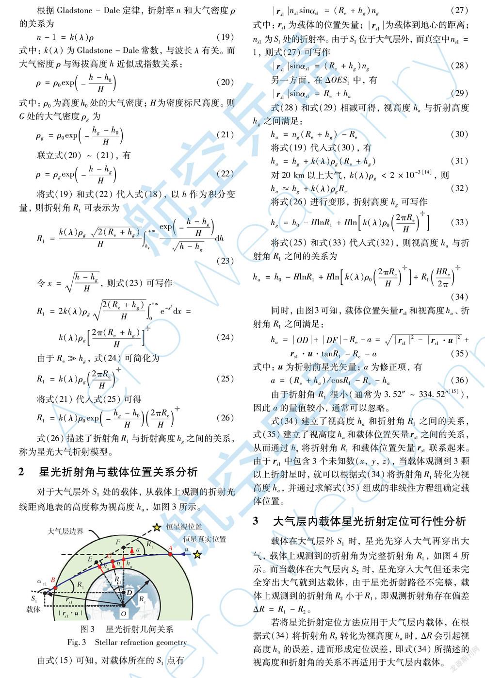
由式(38)可知,當載體在大氣層內飛行且飛行高度h2≤40 km時,若能利用高度計獲得載體的粗略高度h2,則R2與hg的關系隨之確定。 這樣,當大氣層內載體利用星敏感器觀測到折射星的折射角R2后,根據載體的高度信息h2和式(38),將大氣層內觀測折射角R2轉化為折射高度hg,再根據式(32)將折射高度hg轉化為視高度ha,就可以通過求解式(35)組成的非線性方程組計算大氣層內的載體位置。
當載體飛行高度位于20 km以下時,載體所觀測的折射星光將會經過氣象現象劇烈、大氣不穩定的對流層,導致式(20)的大氣密度模型精度嚴重下降,進而影響星光折射間接敏感地平定位精度。 為了使所觀測的折射星光不進入對流層,載體應在20 km以上進行觀測。 因此,所提方法可適用于大氣層內飛行高度在20~40 km的飛行載體。
4 結? 論
針對傳統星光折射間接敏感地平定位方法主要應用于大氣層外載體的局限性,本文從載體在大氣層內、外觀測的折射角偏差出發,對大氣層內載體星光折射間接敏感地平定位的可行性進行分析,得到以下結論:
(1) 對大氣層內載體而言,載體的高度h2越高,折射路徑越完整,觀測折射角R2越大,一方面有利于星敏感器的測量,另一方面,由于R2越接近完整折射角R1,即折射角偏差ΔR越小,星光大氣折射模型描述的關系越準確,進行定位解算的誤差就越小。
(2) 當載體高度h2≤40 km時,折射角偏差ΔR與星敏感器測量精度相當或大于星敏感器的測量精度量級。 根據折射角R2計算視高度ha時,將導致較大的視高度誤差,使傳統星光大氣折射模型不再適用。 因此,傳統星光折射間接敏感地平定位方法只適用于飛行高度在40 km以上的載體。
(3) 當載體在大氣層內且飛行高度在20~40 km時,若能夠獲得載體粗略高度,就可以根據觀測折射角R2計算星光的折射高度hg,進而根據式(32)計算視高度ha,從而通過求解式(35)組成的非線性方程組計算大氣層內載體位置,實現星光折射間接敏感地平定位。
綜合來看,若能利用高度計獲得載體的粗略高度,可以將星光折射間接敏感地平定位方法的應用范圍推廣至大氣層內飛行高度在20~40 km的飛行載體,為實現大氣層內載體的高精度自主導航提供理論基礎。
參考文獻:
[1] 趙雨楠, 王新龍. 星光折射間接敏感地平定位模型的誤差分析[J]. 航空兵器, 2017(1): 33-38.
Zhao Yunan, Wang Xinlong. Error Analysis of Stellar Refraction Indirect Horizon Sensing Positioning Model[J]. Aero Weaponry, 2017(1): 33-38.(in Chinese)
[2] Li H F, Li Z, Lin Q, et al. A High-Precision Autonomous Navigation Method for Medium-High Orbit Satellite Based on Stellar Refraction[C]∥ IEEE/ION Position, Location and Navigation Symposium (PLANS), 2016: 408-414.
[3] Gounley R, White R, Gai E. Autonomous Satellite Navigation by Stellar Refraction[J]. Journal of Guidance, Control, and Dyna-mics, 1984, 7(2): 129-134.
[4] Ning X L, Sun X H, Fang J C, et al. Satellite Stellar Refraction Navigation Using Star Pixel Coordinates[J]. Navigation, 2019, 66(1): 129-138.
[5] Wang X L, Ma S. A Celestial Analytic Positioning Method by Stellar Horizon Atmospheric Refraction[J]. Chinese Journal of Aeronautics, 2009, 22(3): 293-300.
[6] 武鵬飛, 宋峰, 魏合理. 星光導航大氣折射模型及數據模式研究[J]. 現代防御技術, 2017, 45(2): 6-13.
Wu Pengfei, Song Feng, Wei Heli. Atmospheric Refraction Model and Data Mode for Starlight Navigation[J]. Modern Defence Technology, 2017, 45(2): 6-13.(in Chinese)
[7] 寧曉琳, 梁曉鈺, 孫曉函, 等. 地球衛星星光折射導航量測量及其性能對比[J]. 航空學報, 2020, 41(8): 623536.
Ning Xiaolin, Liang Xiaoyu, Sun Xiaohan, et al. Satellite Stellar? Refraction Navigation Measurements and Their Performance: A Comparison[J]. Acta Aeronautica et Astronautica Sinica, 2020, 41(8): 623536.(in Chinese)
[8] Qian H M, Sun L, Cai J N, et al. A Starlight Refraction Scheme with Single Star Sensor Used in Autonomous Satellite Navigation System[J]. Acta Astronautica, 2014, 96: 45-52.
[9] 魏詩卉, 楊春偉, 劉炳琪, 等. 星光折射連續修正方法及制導規劃[J]. 航空學報, 2020, 41(8): 623734.
Wei Shihui, Yang Chunwei, Liu Bingqi, et al. Stellar Refraction: Continuous Correction and Guidance Planning[J]. Acta Aeronautica et Astronautica Sinica, 2020, 41(8): 623734.(in Chinese)
[10] 劉禹, 陳浩, 張麗敏. 構造折射星場方法用于星光折射導航仿真的研究[J]. 上海航天, 2018, 35(1): 43-47.
Liu Yu, Chen Hao, Zhang Limin. Artificial Refracted Star Field Method in Simulation of Autonomous Navigation by Stellar Refraction[J]. Aerospace Shanghai, 2018, 35(1): 43-47.(in Chinese)
[11] 盛裴軒, 毛節泰, 李建國, 等. 大氣物理學[M]. 2版. 北京: 北京大學出版社, 2013: 491-492.
Sheng Peixuan, Mao Jietai, Li Jianguo, et al. Atmospheric Physics [M]. 2nd ed. Beijing: Peking University Press, 2013: 491-492.(in Chinese)
[12] 王國權, 寧書年, 金聲震, 等. 衛星自主導航中星光大氣折射模型的研究方法[J]. 中國礦業大學學報, 2004, 33(6): 616-620.
Wang Guoquan, Ning Shunian, Jin Shengzhen, et al. Research on Starlight Atmospheric Refraction Model in Autonomous Satellite Navigation[J]. Journal of China University of Mining & Technology, 2004, 33(6): 616-620(in Chinese)
[13] 房建成, 寧曉琳, 田玉龍. 航天器自主天文導航原理與方法[M]. 北京: 國防工業出版社, 2006: 108-120.
Fang Jiancheng, Ning Xiaolin, Tian Yulong. Principle and Method of Spacecraft Autonomous Celestial Navigation [M]. Beijing: National Defense Industry Press, 2006: 108-120.(in Chinese)
[14] 房建成, 寧曉琳. 天文導航原理及應用[M]. 北京: 北京航空航天大學出版社, 2006: 185-204.
Fang Jiancheng, Ning Xiaolin. Celestial Navigation Theory and Application [M]. Beijing: Beijing University of Aeronautics & Astronautics Press, 2006: 185-204.(in Chinese)
[15] 寧曉琳, 王龍華, 白鑫貝, 等. 一種星光折射衛星自主導航系統方案設計[J]. 宇航學報, 2012, 33(11): 1601-1610.
Ning Xiaolin, Wang Longhua, Bai Xinbei, et al. A Scheme Design of Satellite Autonomous Navigation System Based on Stellar Refraction[J]. Journal of Astronautics, 2012, 33(11): 1601-1610.(in Chinese)
Feasibility Analysis of Stellar Refraction Indirect Horizon
Sensing Positioning on the Carrier inside the Atmosphere
Zhan Xianjun1, Wang Xinlong1*, Hu Xiaodong2, Ding Xiaokun2
(1. School of Astronautics, Beihang University,Beijing 100191, China;
2. AVIC Xi’an Flight Automatic Control Research Institute, Xi’an 710065, China)
Abstract: The stellar refraction indirect horizon sensing positioning method has the characteristics of strong auto-nomy, high accuracy and low cost, which is a new celestial navigation method with great application prospect. At pre-sent, the traditional stellar refraction indirect horizon sensing positioning method is a celestial positioning method based on the carrier outside the atmosphere. However, most of carriers mainly work in the atmosphere. In order to analyze the feasibility of this stellar refraction positioning method on the carrier inside the atmosphere, the starlight atmospheric refraction model is established based on the refraction law and spherical atmospheric model,and the working mechanism of stellar refraction indirect horizon sensing positioning is analyzed according to the relationship between the stellar refraction angle and the carrier position. Then, the feasibility of the application of the stellar refraction indirect horizon sensing positioning method inside the atmosphere is demonstrated and analyzed by quantitatively analyzing the refraction angle deviation of the carrier inside and outside the atmosphere. The results show that the conventional stellar refraction positioning method is only applicable to the carrier flying above 40 km. If the rough height of the carrier can be obtained by altimeter, the stellar refraction indirect horizon sensing positioning method can be applied to the carrier with a flying altitude of 20~40 km inside the atmosphere.
Key words:? celestial navigation; steller refraction navigation; indirect horizon sensing positioning; stellar atmosphere refraction; refraction angle; mathematical model
收稿日期:2021-06-17
基金項目:國家自然科學基金項目(61673040);航空科學基金項目(20170151002);天地一體化信息技術國家重點實驗室基金項目(2015-SGIIT-KFJJ-DH-01);重點基礎研究項目(2020-JCJQ-ZD-136-12)
作者簡介:詹先軍(1995-),男,福建三明人,博士研究生。
通訊作者:王新龍(1969-),男,陜西渭南人,教授。