溝蝕發生的地貌臨界理論計算中數據獲取方法及應用
2019-11-08 00:56:06劉曉冰王玉璽張興義
農業工程學報 2019年18期
李 浩,楊 薇,劉曉冰,王玉璽,張興義
溝蝕發生的地貌臨界理論計算中數據獲取方法及應用
李 浩1,楊 薇2,劉曉冰1,王玉璽2,張興義1※
(1. 中國科學院東北地理與農業生態研究所,哈爾濱 150081; 2. 黑龍江省水利科學研究院,哈爾濱 150080)
溝蝕發生是一種地貌臨界現象,與溝頭處局地坡度及上方匯水面積有關,而溝蝕發生地貌臨界理論能夠預測溝頭可能發生的位置。該文從溝蝕發生地貌臨界理論起源、數據獲取方式、參數計算方法、影響因素及應用等方面綜合評述了該理論的發展及近年來國內外的有關研究。數據獲取方式主要包括野外實測、高清遙感影像及地形圖測量。參數計算方法包括目視(下限值)法、正交回歸(95%置信區間下限)、正交回歸(下限值)及分位數回歸等。相對剪切力指數值反映區域主要的溝蝕發生機制,臨界常數值反映當前特定外界環境下的溝蝕發生臨界條件。將相對剪切力指數固定后,臨界常數的時間序列變化能夠表征外界環境改變對溝蝕發生的影響。人類活動改變了溝頭上方匯流環境,進而影響臨界條件。溝蝕發生地貌臨界理論可獲取溝道侵蝕風險較大的區域,為溝道侵蝕防治措施布設提供參考。結合高分辨率地形圖,增加表征人類活動影響匯流過程的參數能夠豐富溝蝕發生地貌臨界理論。該理論與已有溝道侵蝕發展模型結合,可將溝頭發生位置和溝道發展過程統一,促進溝道侵蝕全過程的模擬。
地貌;侵蝕;溝;發生;坡度;匯水面積;臨界條件
0 引 言
侵蝕溝的動態發展是土壤退化的重要表征。中國將溝蝕分為淺溝侵蝕、切溝侵蝕、沖溝侵蝕和干溝侵蝕等[1],而國外將其分為臨時性切溝侵蝕和切溝侵蝕[2]。朱顯謨在1956年將現代溝蝕分為淺溝侵蝕和切溝侵蝕,認為淺溝由主細溝演變而來,并能發展為切溝[1]。早期國內學者對淺溝形態的劃分有所不同,但均認為能否阻礙橫向耕作是淺溝與切溝的本質區別[3-5],與美國的臨時切溝侵蝕概念一致。為此,Zhang等[6]在撰寫《Encyclopedia of Soil Science》溝蝕(gully)條目時,將中國定義的淺溝侵蝕與美國定義的淺溝侵蝕歸為同一類溝蝕類型(ephemeral gully)。坡耕地中溝蝕吞蝕耕地,降低農機具耕作效率,是坡耕地土壤侵蝕的主要方式之一[7]。侵蝕溝道是徑流泥沙輸送與污染物運移的重要通道,流域侵蝕產沙的重要來源,其發生發展影響現代地貌發育及演化過程[8]。
溝頭是溝道侵蝕中發展最劇烈的區域,溝頭溯源侵蝕是侵蝕溝發育的主要過程。已有研究表明,侵蝕溝頭的生成存在臨界條件,即當降雨徑流侵蝕力超過土壤阻抗力才能形成,且受土地利用、地表植被、土壤及降雨等因素的綜合制約,并發展形成了溝蝕發生地貌臨界理論。該理論主要研究溝道生成的區域因素。盡管主細溝是淺溝的初期形態,然而由于主細溝由多條細溝匯集而成,且細溝的空間分布隨機性較強[9],因此相對于細溝,該理論更適宜于研究淺溝和切溝的生成臨界條件。
侵蝕溝形成的主要原因是徑流的增大,而徑流的增大多緣于氣候或土地利用方式的改變。氣候變化導致降雨量增加,徑流增大;或者降雨量減少降低植被覆蓋度,而后在降雨量短期增加時,徑流增大。在土地利用方式方面,毀林開荒或過度放牧均可增大徑流。上述過程均受外部環境作用而與溝道自身無關,這難以解釋同一區域內溝蝕過程對外部因素響應的不一致性,比如,1條侵蝕溝趨向發育,而臨近的侵蝕溝保持穩定。為了解釋溝蝕過程對外部因素響應的不一致性,需要增加表征溝道自身因素的內部因素[10],即地貌臨界條件。近年來,該理論在數據獲取方式、參數分析方法、影響因素及應用領域等方面取得一些進展。本文基于前人的研究,介紹了溝蝕發生地貌臨界理論的發展過程及國內外最新研究成果,以期有助于該臨界模型的應用推廣。
1 溝蝕發生地貌臨界理論來源
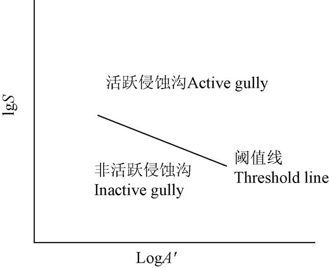
由于采用的基礎數據是侵蝕溝頭的上方匯水面積(簡稱)和局地坡度(簡稱),且結論多為在同一區域下,愈大的上方匯水面積,溝頭生成所需要的坡度愈小,因此,被稱為溝蝕發生地貌臨界理論(圖1)。
Horton[11]較早提出溝頭生成臨界坡長概念,認為當匯流長度超過臨界坡長時,侵蝕溝頭才能形成。Schumm等[12]發現切溝溝頭多形成于局部坡度較大位置。Brice[13]將溝頭處及點繪于雙對數坐標系內以研究二者的關系。Patton等[14]搜集了美國懷俄明、卡羅拉多等多個州的數十條侵蝕溝及未侵蝕溝谷的地形特征,點繪了坡度最大處的及,并在侵蝕溝點群底部目視繪制直線,作為區分侵蝕溝與未侵蝕溝谷的臨界線。該臨界線顯示侵蝕溝溝頭處的與存在反向趨勢(inverse relationship),即溝頭局部坡度越大,溝頭生成所需要的上方匯水面積越小。
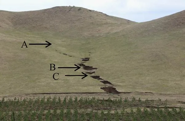
注:A,匯流面積較小,未形成溝頭;B,匯流面積增大,同時坡度超過閾值,形成坡度;C,匯流面積繼續增大,但坡度小于閾值,未形成溝頭。
依照Horton[11]溝頭生成臨界坡長概念,當上方匯流剪切力≥溝道生成臨界值Г時,溝頭開始生成。此時上方匯流剪切力為
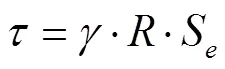
式中為水密度,kg/m3;為徑流水力半徑,m;S為徑流能坡,m/m。對于薄層水流,和S可由徑流深及溝頭局地坡度代替。
Begin和Schumm[15]根據水力半徑()和流量()以及流量()與的經驗關系,替代了徑流剪切力公式中的,得到溝蝕發生地貌臨界條件下Г為
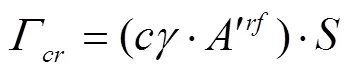
式中Г為臨界剪切力,N/m2;為指數;為常數。基于徑流剪切力公式,該方程融合了和,建立了溝蝕發生臨界剪切力與、關系。
=Г/及=簡化[16]為
·=(3)
式中為相對剪切力指數,等于雙對數坐標系內臨界直線斜率的負值,與溝蝕發生機制有關。為臨界常數,與當地降雨、植被、土地利用等外界因素有關。活躍與非活躍侵蝕溝位于閾值線的上方和下方(圖2)。
此外,Montgomery等[17-18]從理論上研究了緩坡超滲產流、蓄滿產流、滲流及陡坡上薄層崩塌的溝蝕發生臨界條件(圖3)。這幾種溝蝕發生機制作用下形成的侵蝕溝可基本囊括不同坡度、地表覆蓋和擾動類型下的人為加速溝道侵蝕類型。
注:A'為上方匯水面積,hm2;S為局地坡度,m·m-1。
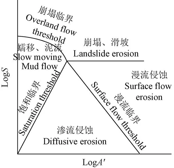
圖3 不同溝蝕生成條件下的臨界條件[17-18]
2 數據采集方法
由于溝蝕發生地貌臨界理論研究的是一定區域內溝道發生的-統計規律,需要大量的(數十條或更多)侵蝕溝頭上方與樣本,因此野外實測、大比例尺地圖和遙感影像提取是獲取數據的主要方法。值是影響溝蝕發生臨界條件分析準確度的主要因素,而野外實測能夠準確判斷溝頭位置,可信度較高。因此,在侵蝕性降雨后對新生成溝頭局地坡度及匯水面積開展測量是較為準確的[19]。然而,實測方法費時費力,導致基于該方法開展溝蝕發生臨界條件的研究相對較少。大比例尺地形圖與遙感影像結合的方法能夠快速獲取與的現勢及歷史情況,有助于研究特定區域溝蝕發生臨界條件隨降雨、土地利用及植被覆蓋等侵蝕環境的變化[20-22]。但地形圖獲取的值可能較實測值偏低(表1)。此外,Vandaele等[19]與Poesen等[23]分別通過實地測量與地形圖2種方法,獲取了同一區域淺溝生成臨界關系方程,發現2種方法獲取的值相似,均為0.40左右,而值分別為0.08與0.025,差異較大。
已有大部分研究都是在溝頭處測量局地坡度,進而獲取上方匯水面積。對不連續、有多個侵蝕溝槽間斷出現的情形,與的測量位置應為距離分水嶺最近的溝頭。也有研究認為,溝頭處的與值與侵蝕溝頭最初形成的與值有一定的偏差[19]。這是因為在溯源侵蝕溝頭的作用下,最初形成的侵蝕溝頭向上方移動,離開了原始位置。因此,應當在溝頭最初形成的位置測量與值,而該位置很有可能為溝底最大坡度處。由此,預測溝頭位置是溝道體系演化理論的關鍵[24],而且已有溝道侵蝕模型多需要人為指定溝頭生成位置,進行溝長溝深演化過程的模擬[25-26]。
近年來,小型無人機應用快速發展,其結合動態測量數據后處理或實時差分動態定位技術,能夠準確獲取溝道及匯水區的數字地面模型,便于內業解譯小型切溝及淺溝與值等信息。由于該技術具有成本低、快速、精度高的優勢,目前已應用于溝蝕發生臨界地貌條件的相關研究[27]。在三維激光掃描方面,由于該方法主要用于獲取單條溝道/溝頭的精確侵蝕形態及演化[28],因此其在溝蝕發生臨界地貌條件方面的研究相對較少。
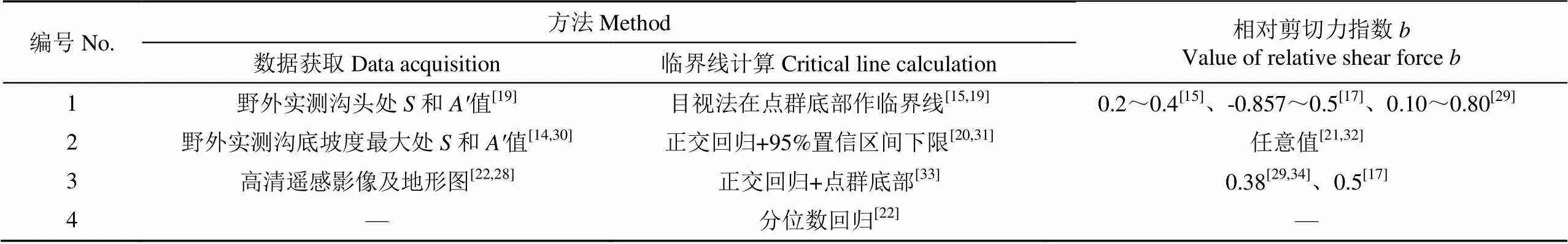
表1 已有文獻中溝蝕發生地貌臨界模型方法及具體參數
3 參數計算方法
目前已發展了多種計算與值的方法,可分為目視+下限值法、正交回歸+95%置信區間下限法、正交回歸+下限值法和分位數回歸法。基本過程均為:1)將溝頭局地坡度和上方匯水面積點繪于雙對數坐標系中;2)根據一定的原則繪制臨界線,該臨界線的斜率負值即為相對剪切力指數值;3)根據一定的原則,由式(3)計算臨界常數值。因此,不同方法之間的區別為和的計算方式不同。
3.1 目視+下限值法
Begin和Schumm[15]使用侵蝕溝點群底部的兩點或多點目視繪制直線,得到值;將點群最低點(lower-most points)的和及值代入到式(3)的左側,得到值。已有研究[19,35-37]較為完整得描述了該方法。然而,該方法依賴點群底部2個點作出臨界線,人為主觀性較強,很有可能作出多條臨界線,且受極端點的影響較大。因此,實際應用中通常需要剔除異常極值點,以保證臨界條件的合理性[32]。
3.2 正交回歸+95%置信區間下限法
Gómez 等[20,31]采用正交回歸分析獲得點群的回歸線,以表征侵蝕溝點群的平均地貌臨界條件,然后將其95%置信區間的下限作為溝道生成臨界線。盡管該方法考慮了侵蝕溝點群-的統計關系,但并不完全符合溝蝕發生的臨界條件概念,因為臨界線下方仍有部分侵蝕溝點,因此獲取的值可能大于實際的溝蝕發生臨界值,即可能偏高。
3.3 正交回歸+下限值法
Vandekerckhove等[33]改進了3.2中的方法,首先應用正交最小二乘法獲得平均地貌臨界條件,將臨界線平行向下移動到侵蝕點群的底部,從而計算臨界常數。該方法既具有大量侵蝕溝道的統計學意義,又兼顧溝道生成的臨界條件,考慮了所有溝道侵蝕發生情況下的-統計關系,應用較廣[38]。
3.4 分位數回歸法
Maugnard等[22]采用分位數回歸分析的方法,研究了德國瓦隆尼西亞地區2006年之前、2006年及2009年3個時間段內農用地溝蝕發生的地貌臨界條件。他們將分位數設置為0來獲取臨界線,即認為-點位于該臨界線下方的統計學概率為0,并獲取相應與值。該方法能有效反映臨界區域附近點群的平均權重,優于全體點群統計量,且考慮了離群點信息。同時侵蝕溝樣本數應達到50個,以弱化樣本數目對臨界線回歸效果的影響。
4 臨界模型因子值及影響因素
4.1 相對剪切力指數b
相對剪切力指數值代表研究區域的溝蝕發生機制,因此不同研究區域的值可能取值不同(表1)。Begin等[15]根據水力半徑()和流量()以及流量()與流域面積的經驗關系和徑流剪切力公式,給出理論上取值范圍為0.2~0.4。Montgomery等[17]推導了多種溝道侵蝕機制下(緩坡超滲產流、蓄滿產流、滲流及陡坡薄層崩塌)臨界關系方程形式,給出理論上取值范圍為?0.857~0.5。Vandekerckhove等[33]認為當值大于0.2時,主要侵蝕過程為地表徑流侵蝕,而值小于0.2時,主要侵蝕過程為地下徑流及溝體崩落。值愈低,愈能反映下滲水流促進潛蝕及溝底下切后的溝頭溝壁崩塌。Vandaele等[19]認為值應為0.40左右。Poesen等[7]匯總了諸多侵蝕環境及數據獲取方法下的溝道生成臨界條件文獻,結果表明值范圍較廣(0.10~0.80)(圖4)。
4.2 臨界常數k
臨界常數代表研究區域的外部侵蝕環境,與地質、土壤、氣候和植被等因素相關。當研究區域人為活動影響外部侵蝕環境(如土地利用)時,值可能隨之發生改變。Torri和Poesen[34]參考已有研究[17,29]將值固定為常數(0.38或0.50),通過值的變化來評估溝頭前進與土地利用/植被覆蓋度的關系。結果表明,隨著植被覆蓋度的增加(耕地、草地及林地),溝蝕發生臨界常數值也隨之增大。同時隨著降雨量/降雨強度的降低,溝蝕發生臨界常數值隨之減小,如半干旱大陸性氣候區(如中國黃土高原地區)的值大于溫帶海洋性氣候區(如中歐),而熱帶氣候區的值最低(非洲和巴西等)。Hayas等[39]應用10期遙感影像,研究了1956-2013年降雨、土地利用及植被覆蓋對切溝溝頭位置及生成臨界條件的影響。結果顯示,臨界常數值受降雨因素影響較大,且日降雨量極值與臨界條件的相關性最強,而植被覆蓋在降雨量較少時對值的作用更為顯著。然而由于臨界常數值的影響因素較多,因此缺乏將其與單一影響因素進行定量關系的研究。

1.比利時中部 2.比利時中部 3.葡萄牙 4.法國 5.英國南部:實地調查 6.美國卡羅拉多州 7.美國內華達州 8.美國加利福尼亞州 9.美國俄勒岡州 10.澳大利亞 11.中國黑龍江(1) 12.中國黑龍江(2)
1.Central Belgium 2.Central Belgium 3.Portugal 4.France 5.UK (South Downs) 6.USA (Colorado) 7.USA (Sierra Nevada) 8.USA (California) 9.USA (Oregon) 10.Australia (New SouthWales) 11.China (Heilongjiang)(1) 12.China (Heilongjiang)(2)
注:1、5、7~10均為實地調查;11和12均為實地調查的坡度,地形圖的面積;其他為地形圖。
Note: 1, 5 and 7-10 from field survey; for 11 and 12, slope from field survey and area from topographic map; others from aerial photos and topographic map.
圖4 發育中淺溝與切溝的臨界坡度與上方匯水面積關系[7,40]
Fig.4 Relationship between critical slope and catchment area for development of gullies[7,40]
4.3 其他影響因素
上方匯水面積的大小影響溝頭生成臨界條件。Begin等[15]假設的是在形成洪峰流量時,上方匯水區內所有產流都匯集在溝頭的理想情景。而該假設只有在溝頭匯水面積較小,或降雨歷時足夠長時才能成立,即溝頭處流量才能用上方匯水面積替代。在上方匯水面積較大或降雨歷時較短的情形下,匯水區產流并不一定能全部到達侵蝕溝頭,即形成洪峰流量時溝頭上方匯水區域小于全部匯水區,導致值偏小[32]。Rossi等[41]從理論上推導了局部匯水區產流匯集到溝頭對-關系因子值的影響,建議避免將該理論應用于大型侵蝕溝的生成機制研究。
農耕地中的道路降低了降雨入滲速率,增大了集中徑流量與速度,改變了流域匯流時間,可能導致侵蝕溝生成所需臨界坡度變小,因此-臨界關系可用于道路對侵蝕溝生成影響的研究。Katz等[42]提取了美國科羅拉多州林地中道路排水導致的侵蝕溝溝頭(簡稱區域1)的和值,并繪制了臨界線。同時獲取了在道路排水作用下有集中徑流但未形成侵蝕溝(簡稱區域2),以及林地自然集中徑流但未形成侵蝕溝(簡稱區域3)的點位和值,并點繪在區域1的臨界線圖中(參考圖2)。結果顯示,區域1與2的-點分別位于臨界線的上方和下方,表明在道路集中徑流的作用下,該區域侵蝕溝頭的生成存在明確的臨界關系。同時區域3的-點分布在臨界線的上方與下方,說明該臨界線不能明確林地自然徑流下是否形成侵蝕溝,即自然徑流下與道路集中徑流下侵蝕溝生成的地貌臨界條件是不同的。
5 溝道生成臨界理論在中國的應用
中國學者在調查與研究黃土高原淺溝和切溝的地貌臨界條件方面做了不懈的努力,積累了寶貴的數據。羅來興等[43]將黃河中游黃土丘陵區侵蝕溝劃分為淺溝、切溝、沖溝、坳溝及河溝。陳永宗[3]對各種侵蝕溝平均匯水面積與坡度進行了統計,并點繪在半對數和對數圖中,發現羅來興劃分的侵蝕溝類型滿足了溝谷發育過程的連續性和階段性要求,可將黃土丘陵區侵蝕溝發展的順序概化為淺溝→切溝→沖溝→坳溝→河溝。其他有關黃土高原的地貌臨界條件研究多集中于淺溝的臨界坡度與臨界坡長的上下限等的統計分析[5,44-46]。
隨著3S技術的發展,近些年來中國學者應用溝蝕發生臨界理論開展了定位研究[47]。約70%的研究集中于黃土高原區域,而在東北黑土區[47]、南方紅壤區[48]、長江上游紫色丘陵區[49]和內蒙古風沙區[50]也有部分研究。在研究方法上,多使用野外實測或高分辨率遙感影像獲取侵蝕溝頭位置,進而使用地形圖獲取侵蝕溝頭局地坡度及上方匯水面積。由于1:10 000地形圖是目前能夠獲取到的覆蓋面積最廣、最為詳細的地形圖,因此被廣泛應用。在閾值線和參數獲取方式上,幾乎所有研究均使用目視(下限值)法,對不同計算方式可能帶來誤差的考慮較少。
在具體研究方面,Cheng等[51-52]使用實時差分定位(real-time kinematic,RTK)實測匯水區地形圖及溝頭處坡度,研究了黃土高原、東北黑土區、內蒙古風沙區等溝蝕發生地貌臨界條件。張永光等[40,47,53]等搜集了東北黑土區鶴山農場2個小流域內的淺溝和切溝和數據,通過下限點目視繪制臨界線,并對比了二者的-關系式。結果表明,淺溝和切溝的值近似(0.141與0.148),可能是因為研究區溝蝕生成機制是近似的;同時值有一定差異(0.072與0.052),表明淺溝與切溝生成的地貌臨界條件是不同的。李斌兵等[54]在黃土高原丘陵區借助RTK實測數據及GIS方法,建立了淺溝侵蝕和切溝侵蝕發生判定式,并提取了淺溝和切溝侵蝕分布區與野外調查結果相當吻合。
此外,已有研究表明,壟作影響東北黑土區坡面匯流侵蝕過程。相對于自然坡面,橫坡壟作可能擴大或減少上游匯水面積,而順坡壟作明顯加劇了坡面匯流與侵蝕過程[55],從而影響溝蝕發生臨界條件。因此,在東北黑土區應用時,需要在模型中添加考慮壟作的復合地形因子,以達到更好的預測效果。
6 結論與展望
溝蝕發生地貌臨界理論將溝頭生成視為一種臨界現象,適宜淺溝或小型切溝的生成研究。溝頭位置是在已有多場降雨作用下形成的,能夠代表區域內當前溝蝕發生的平均地貌臨界條件。基于時間序列的溝蝕發生地貌臨界條件,可用于研究自然或人為因素(降雨、植被類型和土地利用等)對溝頭生成過程的影響及變化。
溝蝕發生地貌臨界理論有助于溝道侵蝕防治措施的布設。該理論能夠給出溝蝕發生的臨界條件,進而預測溝頭位置的空間分布,即可能發生溝道侵蝕的區域。因此可針對溝道侵蝕風險性大的區域布設溝道防治措施。鑒于已有研究數據處理方式較為一致,可通過對比不同生態類型區內的溝道生成閾值,為溝道侵蝕防治總體規劃的區域差異化布設提供參考。
人為擾動是現代溝道形成的主要原因。人類活動如修建梯田和農田道路,及改壟等改變了農田微地貌,影響坡面匯水過程,進而改變溝頭上方匯水面積。而高分辨率地形圖能夠反映農田微地貌的改變。近年來高清遙感影像、基于照片的三維重建及激光雷達技術的發展,促進了高分辨率地形圖的獲取。因而結合上述新技術獲取的高分辨率地形圖,應用溝蝕發生地貌臨界理論可量化人為活動對溝道形成的影響。
與已有溝道侵蝕發展模型結合亦是溝蝕發生地貌臨界理論的另一發展方向。目前大部分的溝道侵蝕發展模型(如AnnAGNPS,REGEM)可以模擬溝道發展過程,但多需要人為確定溝頭位置,而溝蝕發生地貌理論的主要作用是預測溝頭可能發生的位置。因此二者的結合可將溝頭發生位置和溝道發展過程整合,促進溝道侵蝕全過程的模擬。
[1] 朱顯謨. 黃土區土壤侵蝕的分類[J]. 土壤學報,1956,4(2):99-115.
[2] Foster G. Understanding ephemeral gully erosion[M]// Board on Agriculture, National Research Council. Committee on Conservation Needs and Opportunities, Assessing the National Resources Inventory. Washington D C: National Academy Press, 1986:90-125.
[3] 陳永宗. 黃河中游黃土丘陵區的溝谷類型[J]. 地理科學,1984,4(4):35-41.
Chen Yongzong. The classification of gully in hilly loess region in the middle reaches of the Yellow River [J]. Scientia Geographica Sinica, 1984, 4(4): 35-41. (in Chinese with English abstract)
[4] 黃秉維. 陜甘黃土區域土壤侵蝕的因素和方式[J]. 地理學報,1953,20(2):63-75.
[5] 劉元保,朱顯謨,周佩華,等. 黃土高原坡面溝蝕的類型及其發生發展規律[J]. 水土保持研究,1988(1):9-18.
[6] Zhang Fenli, Chihua H. Gully Erosion[M]//Encyclopedia of Soil Science. Boca Raton, USA: CRC Press, 2006.
[7] Poesen J, Nachtergaele J, Verstraeten G, et al. Gully erosion and environmental change: Importance and research needs[J]. Catena, 2003, 50(2): 91-133.
[8] 劉宇. 土壤侵蝕研究中的景觀連通度:概念、作用及定量[J]. 地理研究,2016,35(1):195-202.
Liu Yu. Landscape connectivity in soil erosion research: Concepts, implication and quantification[J]. Geographical Research, 2016, 35(1): 195-202. (in Chinese with English abstract)
[9] 和繼軍,宮輝力,李小娟,等. 細溝形成對坡面產流產沙過程的影響[J]. 水科學進展,2014,25(1):90-97.
He Jijun, Gong Huili, Li Xiaojuan, et al. Effects of rill development on runoff and yielding processes[J]. Advances in Water Science, 2014, 25(1): 90-97. (in Chinese with English abstract)
[10] Schumm S A. Geomorphic thresholds: The concept and its applications[J]. Transactions of the Institute of British Geographers, 1979, 4(4): 485-515.
[11] Horton R E. Erosional development of streams and their drainage basins: Hydrophysical approach to quantitative morphology[J]. Journal of the Japanese Forestry Society, 1945, 56(3): 275-370.
[12] Schumm S A, Hadley R F. Arroyos and the Semiarid Cycle of Erosion[J]. American Journal of Science, 1957, 255(3): 161-74.
[13] Brice J C. Erosion and deposition in the loess-mantled Great Plains, Medicine Creek drainage basin, Nebraska[M]. US: US Government Printing Office, 1966.
[14] Patton P C, Schumm S A. Gully erosion, Northwestern Colorado: A threshold phenomenon [J]. Geology, 1975, 3(2): 88-90.
[15] Begin Z B, Schumm S A. Instability of alluvial valley floors: A method for its assessment[J]. Transactions of the ASAE, 1979, 22(2): 0347-0350.
[16] Leopold L B, Wolman M G, Miller J P. Fluvial processes in geomorphology[J]. Geographical Journal, 1964, 131(1): 454-456.
[17] Montgomery D R, Dietrich W E. A physically based model for the topographic control on shallow landsliding[J]. Water Resources Research, 1994, 30(4): 1153-1171.
[18] Prosser I P, Abernethy B. Predicting the topographic limits to a gully network using a digital terrain model and process thresholds[J]. Water Resources Research, 1996, 32(7): 2289-2298.
[19] Vandaele K, Poesen J, Govers G, et al. Geomorphic threshold conditions for ephemeral gully incision[J]. Geomorphology, 1996, 16(2): 161-173.
[20] Gómez Gutiérrez á, Schnabel S, Lavado Contador F. Gully erosion, land use and topographical thresholds during the last 60 years in a small rangeland catchment in SW Spain[J]. Land Degradation & Development, 2009, 20(5): 535-550
[21] López A H, Poesen J, Vanwalleghem T. Rainfall and vegetation effects on temporal variation of topographic thresholds for gully initiation in mediterranean cropland and olive groves[J]. Land Degradation & Development, 2017, 28(8): 2540-2552.
[22] Maugnard A, Van Dyck S, Bielders C L. Assessing the regional and temporal variability of the topographic threshold for ephemeral gully initiation using quantile regression in Wallonia (Belgium)[J]. Geomorphology, 2014, 206: 165-177.
[23] Poesen J, Govers G, Boardman J, et al. Gully erosion in the loam belt of Belgium: Typology and control measures[C]// Proceedings of the Soil Erosion on Agricultural Land. Coventry, UK: British Geomorphological Research Group, 1990.
[24] Montgomery D R, Dietrich W E. Where do channels begin? [J]. Nature, 1988, 336(6196): 232-234.
[25] Li H, Cruse R M, Bingner R L, et al. Evaluating ephemeral gully erosion impact onL. yield and economics using AnnAGNPS [J]. Soil & Tillage Research, 2016, 155: 157-165.
[26] Bingner R L, Theurer F D, Yuan Y. AnnAGNPS Technical Processes Documentation (Version 4.0)[M]. US: USDA-ARC National Sedimentation Laboratory & USDA-NRCS National Water and Climate Center, 2007.
[27] Gudino-Elizondo N, Biggs T, Castillo C, et al. Measuring ephemeral gully erosion rates and topographical thresholds in an urban watershed using unmanned aerial systems and structure from motion photogrammetric techniques[J]. Land Degradation & Development, 2018, 29(6): 1896-1905.
[28] Rengers F K, Tucker G E. The evolution of gully headcut morphology: A case study using terrestrial laser scanning and hydrological monitoring [J]. Earth Surface Processes and Landforms, 2015, 40(10): 1304-1317.
[29] Knapen A, Poesen J. Soil erosion resistance effects on rill and gully initiation points and dimensions[J]. Earth Surface Processes and Landforms, 2010, 35(2): 217-228
[30] 蘇子龍,崔明,范昊明. 東北漫崗黑土區防護林帶分布對淺溝侵蝕的影響[J]. 水土保持研究,2012,19(3):20-23.
Zhang Zilong, Cui Ming, Fan Haoming.Effect of protective forest belt on ephemeral gully erosion in Northeast China with black soils[J]. Journal of Soil and Water Conservation, 2012, 19(3): 20-23. (in Chinese with English abstract)
[31] Vandekerckhove L, Poesen J, Wijdenes D O, et al. Topographical thresholds for ephemeral gully initiation in intensively cultivated areas of the Mediterranean[J]. Catena, 1998, 33(3/4): 271-292.
[32] Vanwalleghem T, Poesen J, Nachtergaele J, et al. Characteristics, controlling factors and importance of deep gullies under cropland on loess-derived soils[J]. Geomorphology, 2005, 69(1/2/3/4): 76-91.
[33] Vandekerckhove L, Poesen, J, Oostwoud Wijdenes D, et al. Thresholds for gully initiation and sedimentation in Mediterranean Europe[J]. Earth Surface Processes & Landforms, 2000, 25(11): 1201-1220.
[34] Torri D, Poesen J. A review of topographic threshold conditions for gully head development in different environments[J]. Earth-Science Reviews, 2014, 130: 73-85.
[35] Poesen J W A, Hooke J M. Erosion, flooding and channel management in Mediterranean environments of southern Europe[J]. Progress in Physical Geography, 2016, 21(2): 157-199.
[36] 胡剛,伍永秋.發生溝蝕(切溝)的地貌臨界研究綜述[J]. 山地學報,2005,23(5):565-570.
Hu Gang, Wu Yongqiu. Progress in the study of geomorphic threshold theory in channel (gully) erosion[J]. Journal of Mountain Science, 2005, 23(5): 565-570. (in Chinese with English abstract)
[37] 劉曉冰,張興義. 溝道侵蝕的多樣性和發生過程及研究展望[J]. 土壤與作物,2018(2):90-102.
Liu Xiaobing, Zhang Xingyi. Gully erosion: diversity, processes and prospects[J]. Soils and Crops, 2018(2): 90-102. (in Chinese with English abstract)
[38] Morgan R P C, Mngomezulu D. Threshold conditions for initiation of valley-side gullies in the Middle Veld of Swaziland[J]. Catena, 2003, 50(2): 401-414.
[39] Hayas A, Vanwalleghem T, Laguna A, et al. Reconstructing long-term gully dynamics in Mediterranean agricultural areas[J]. Hydrology and Earth System Sciences, 2017, 21(1): 235-249.
[40] 張永光,伍永秋,劉洪鵠,等. 東北漫崗黑土區地形因子對淺溝侵蝕的影響分析[J]. 水土保持學報,2007,21(1): 35-38.
Zhang Yongguang, Wu Yongqiu, Liu Honghu, et al.Effect of topography on ephemeral gully erosion in Northeast China with black soils[J]. Journal of Soil and Water Conservation, 2007, 21(1): 35-38. (in Chinese with English abstract
[41] Hayas A, Vanwalleghem T, Laguna A, et al. Reconstructing long-term gully dynamics in Mediterranean agricultural areas[J]. Hydrology and Earth System Sciences, 2017, 21(1): 235-249.
[41] Rossi M, Torri D, Santi E. Bias in topographic thresholds for gully heads[J]. Natural Hazards, 2015, 79(S1): 51-69.
[42] Katz H A, Daniels J M, Ryan S. Slope-area thresholds of road-induced gully erosion and consequent hillslope-channel interactions[J]. Earth Surface Processes and Landforms, 2014, 39(3): 285-295.
[43] 羅來興. 劃分晉西、陜北、隴東黃土區域溝間地與溝谷的地貌類型[J]. 地理學報,1956,23(3):201-222.
Luo Laixing. A tentative classification of landforms in the Loess Plateau[J]. Acta Geographica Sinica, 1956, 22(3): 201-222. (in Chinese with English abstract)
[44] 張科利,唐克麗,王斌科. 黃土高原坡面淺溝侵蝕特征值的研究[J]. 水土保持學報,1991,5(2):8-13.
Zhang Keli, Tang Keli, Wang Binke. A study on characteristic value of shallow gully erosion on slope farmland in the Loess Plateau[J]. Journal of Soil and Water Conservation, 1991, 5(2): 8-13. (in Chinese with English abstract)
[45] 姜永清,王占禮. 瓦背狀淺溝分布特征分析[J]. 水土保持研究,1999,6(2):181-184.
Jiang Yongqing, Wang Zhanli, Hu Guangrong, et al. Distribution features of shallow gully[J]. Research of Soil and Water Conservation, 1999, 6(2): 181-184. (in Chinese with English abstract)
[46] 秦偉,朱清科,趙磊磊,等. 基于RS和GIS的黃土丘陵溝壑區淺溝侵蝕地形特征研究[J]. 農業工程學報,2010,26(6):58-64.
Qin Wei, Zhu Qingke, Zhao Leilei, et al. Topographic characteristics of ephemeral gully erosion in loess hilly and gully region based on RS and GIS[J]. Transactions of the Chinese Society of Agricultural Engineering (Transactions of the CSAE), 2010, 26(6): 58-64. (in Chinese with English abstract)
[47] 胡剛,伍永秋,劉寶元,等. 東北漫川漫崗黑土區淺溝和切溝發生的地貌臨界模型探討[J]. 地理科學,2006,26(4): 449-454.
Hu Gang, Wu Yongqiu, Liu Baoyuan, et al. Geomorphic threshold model for ephemeral gully incision in rolling hills with black soil in Northeast China[J]. Scientia Geographica Sinica, 2006, 26(4): 449-454. (in Chinese with English abstract)
[48] 楊文利,朱平宗,趙建民,等. 南方紅壤丘陵區馬尾松人工林地淺溝形態特征[J]. 西北農林科技大學學報:自然科學版,2019,47(8):100-108.
Yang Wenli, Zhu Zongping, Zhao Jianmin, et al. Morphological characteristics of ephemeral gullies ofplantations in the Red Soil Hilly Region of southern China[J]. Journal of Northwest A & F University: Natural Science Edition, 2019, 47(8): 100-108. (in Chinese with English abstract)
[49] 何福紅. 基于“3S”技術的溝蝕研究方法構建與應用[D].北京:中國農業科學院,2006.
[50] 程宏,王升堂,伍永秋,等. 坑狀淺溝侵蝕研究[J]. 水土保持學報,2006,20(2):39-41.
Cheng Hong, Wang Shengtang, Wu Yongqiu, et al. Study on hole-ephemeral gullies erosion [J]. Journal of Soil and Water Conservation, 2006, 20(2): 39-41, 58. (in Chinese with English abstract)
[51] Cheng H, Wu Y, Zou X, et al. Study of ephemeral gully erosion in a small upland catchment on the Inner-Mongolian Plateau[J]. Soil and Tillage Research, 2006, 90(1/2): 184-193
[52] Cheng H, Zou X, Wu Y, et al. Morphology parameters of ephemeral gully in characteristics hillslopes on the Loess Plateau of China[J]. Soil and Tillage Research, 2007, 94(1): 4-14
[53] Zhang Y, Wu Y, Liu B, et al. Characteristics and factors controlling the development of ephemeral gullies in cultivated catchments of black soil region, Northeast China[J]. Soil and Tillage Research, 2007, 96(1/2): 28-41.
[54] 李斌兵,鄭粉莉,張鵬. 黃土高原丘陵溝壑區小流域淺溝和切溝侵蝕區的界定[J]. 水土保持通報,2008,28(5):16-20.
Li Binbing, Zheng Fenli, Zhang Peng. Geomorphic threshold determination for ephemeral gully and gully erosion areas in the loess hilly gully region[J]. Bulletin of Soil and Water Conservation, 2008, 28(5): 16-20. (in Chinese with English abstract)
[55] 宋玥,張忠學. 不同耕作措施對黑土坡耕地土壤侵蝕的影響[J]. 水土保持研究,2011,18(2):14-16.
Song Yue, Zhang Zhongxue. The effect of different tillage measures on soil erosion in slope farmland in black soil region[J]. Research of Soil and Water Conservation, 2011, 18(2): 14-16. (in Chinese with English abstract)
Data obtained method and application for topographic threshold theory calculation of gully initiation
Li Hao1, Yang Wei2, Liu Xiaobing1, Wang Yuxi2, Zhang Xingyi1※
(1.150081,; 2.150080,)
Gully initiation topographic threshold theory describes gully initiation condition, and is represented by the size of catchment that controls discharge, and local slope at the channel head that controls the velocity of runoff. The main cause of gully formation is excessive (sub) surface runoff, a condition that might be brought about by either climate change or alternations in land use. In this study, this theory was reviewed from the following aspects: theory development, data sources, threshold value calculating methods, influencing factors and applications. The gully initiation threshold concept was originally developed to explain the onset of instability in 1 gully while its neighbours remained stable. The relative area (or shear stress) exponent was generally interpreted in relation to the gully erosion process in the catchment. Values higher than 0.2 were associated with erosion by surface runoff and those lower than 0.2 indicated subsurface processes or mass movement. The threshold coefficient reflected the resistance of the site to gully head development, affected by rainfall, land use, etc. The threshold values variation also depended on the methodology, including field reconnaissance survey and high-resolution remote sensing images as well as digital elevation model. The latter were more convenient for data acquisition, although field reconnaissance survey data would be more accurate. With fast development of unmanned aerial vehicles, high spatial resolution orthophotos derived from structure-from-motion photography could be used to identify the location of gully heads and corresponding catchment size and local slope values. In the early research, the topographic threshold straight line was eye-fitted through the “lower-most” points in a log–log scatter plot. The negative slope of that line was equal to relative area exponent value. Then the threshold value could be obtained as the intercept. Since this threshold line was manually drawn, it did not have statistical meaning. This method might also be problematic as multiple thresholds could exist, and the threshold line was very sensitive to extreme values. Based on orthogonal regression, the mean threshold line was fitted through the data-points. Then the minimum threshold line was defined either by the lower limit of the 95% prediction confidence interval around the mean threshold line, or parallel line below the lower limit of the scatter of the data. Quantile regression was recommended because it was statistically-based and robust to outliers. Since the domination mechanisms of gully initiation would not change within decades in a certain region, the relative area exponent could be fixed as a constant value. According to this hypothesis, the threshold coefficient of muti-periods could be used to investigate human effect on gully initiation. In China, about 70% of the research was carried out in the Loess Plateau region. The 1:10 000 topographic map was widely used to obtain local slope and catchment size, since this was the most extensive and detailed topographic map currently available. Most studies extracted the threshold conditions by using the eye-fitted line through the “lower-most” points, and few consideration was carried out for the potential errors between different calculation methods. Road construction altered the surface hydrology, and the road surface condition reduced the critical slope for a given drainage area required for gullying. Agricultural reclamation was the main reason for gully development in the Northeastern China, where ridge tillage was widely applied. Contour ridge changed runoff pathways and rearranged drainage networks, and longitudinal ridge accelerated flow concentration. Consideration of ridge-direction effect was important for gully initiation topographic threshold theory applications in this region. Using high-resolution topographic maps and adding the parameters that characterized the human activities effect on concentrated surface runoff could enrich the gully initiation topographic threshold theory. Current gully erosion model could simulate gully development while gully head needed to be mannually located. Hence gully initiation topographic threshold theory could be promoted by combining with such models, since this theory could predict where gully initiated.
geomorphology; erosion; gully; initiation; slope; catchment area; threshold condition
李 浩,楊 薇,劉曉冰,王玉璽,張興義. 溝蝕發生的地貌臨界理論計算中數據獲取方法及應用[J]. 農業工程學報,2019,35(18):127-133.doi:10.11975/j.issn.1002-6819.2019.18.016 http://www.tcsae.org
Li Hao, Yang Wei, Liu Xiaobing, Wang Yuxi, Zhang Xingyi. Data obtained method and application for topographic threshold theory calculation of gully initiation[J]. Transactions of the Chinese Society of Agricultural Engineering (Transactions of the CSAE), 2019, 35(18): 127-133. (in Chinese with English abstract) doi:10.11975/j.issn.1002-6819.2019.18.016 http://www.tcsae.org
2019-04-06
2019-08-10
國家重點研發項目(2017YFC0504200);國家自然科學青年基金(41601289)聯合資助
李 浩,助理研究員,博士,主要從事地理信息系統與溝道侵蝕研究。Email:lihao@iga.ac.cn.
張興義,研究員,博士,博士生導師,主要從事黑土生態研究。Email:zhangxy@iga.ac.cn
10.11975/j.issn.1002-6819.2019.18.016
S157.1
A
1002-6819(2019)-18-0127-07
猜你喜歡
體育科技文獻通報(2022年3期)2022-05-23 13:46:54
當代陜西(2022年5期)2022-04-19 12:10:18
新世紀智能(數學備考)(2021年9期)2021-11-24 01:14:28
遼金歷史與考古(2021年0期)2021-07-29 01:06:54
湘潮(上半月)(2021年4期)2021-07-20 08:05:28
汕頭大學學報(自然科學版)(2020年4期)2020-12-14 07:05:00
科技傳播(2019年22期)2020-01-14 03:06:54
民用飛機設計與研究(2019年4期)2019-05-21 07:21:24
中國科技博覽(2016年2期)2016-04-25 20:32:39
小學生導刊(2016年34期)2016-04-11 00:49:44