雷州半島海岸帶主體功能區劃研究
2021-08-20 14:33:08劉耀謙朱飛航譚瑤梁春林孫省利
海洋開發與管理
2021年11期
劉耀謙 朱飛航 譚瑤 梁春林 孫省利

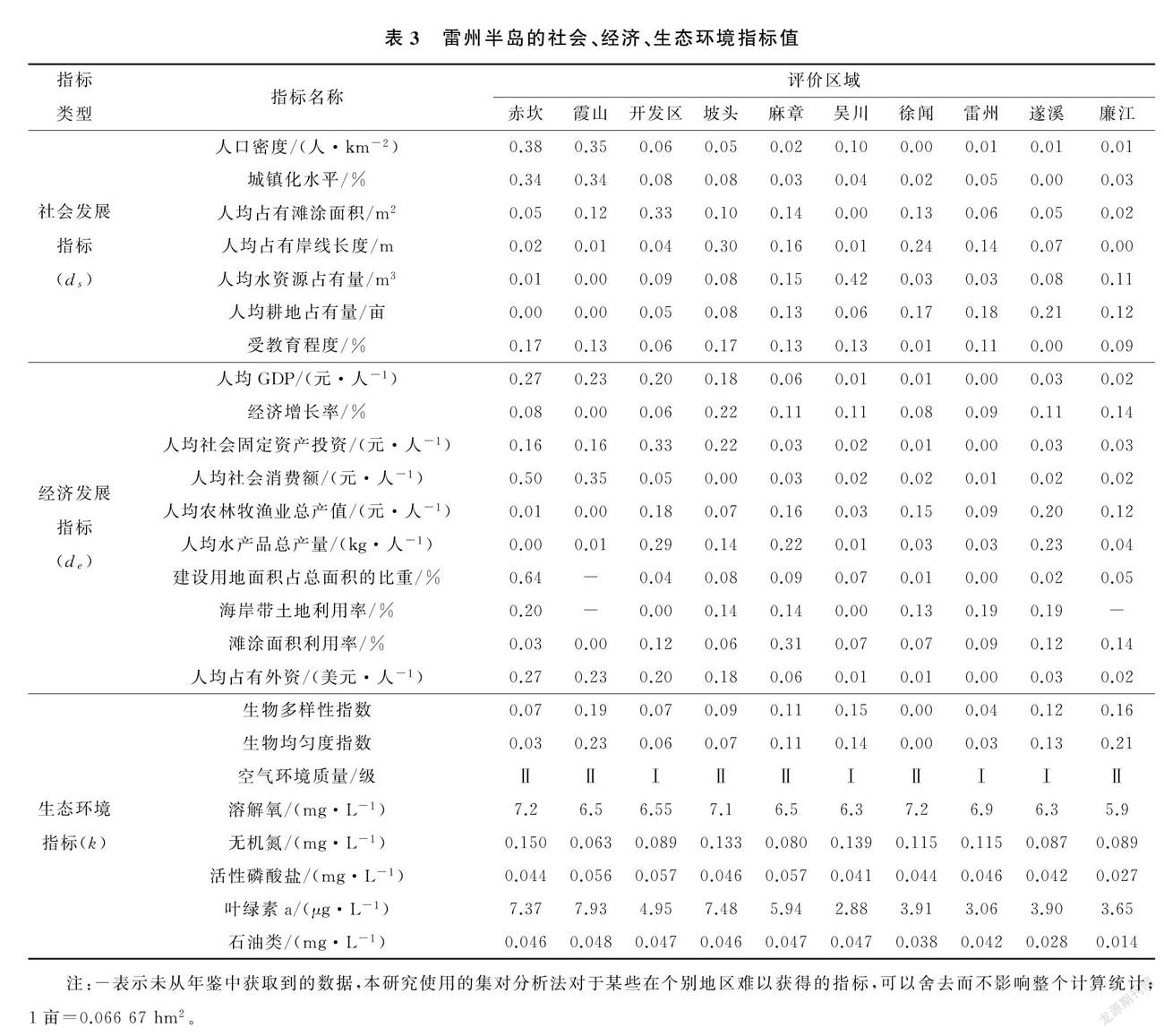
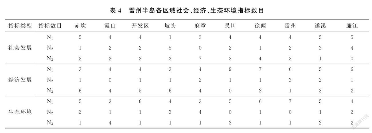
摘要:文章采用基于集對分析法的社會、經濟與生態環境協調發展模型研究雷州半島海岸帶主體功能區劃,確定邊界范圍,構建評價指標體系。將整個雷州半島作為海岸帶,指標體系劃分為三大類共27個指標。赤坎區、坡頭區、麻章區屬于基本協調發展;開發區(含東海)、遂溪縣、雷州市、吳川市、徐聞縣和廉江市屬于高度協調發展;霞山區屬于弱協調或不協調發展。雷州半島各區域社會、經濟發展對環境損害較小。霞山區、開發區(含東海)劃分為重點開發區,遂溪縣、雷州市、廉江市、吳川市和徐聞縣劃分為限制開發區,禁止開發區單獨劃出,包括3個國家級自然保護區、1個國家級風景名勝區和2個國家森林公園。
關鍵詞:海岸帶主體功能區劃;雷州半島;集對分析法;邊界范圍;評價指標體系
中圖分類號:P74;X321文獻標志碼:A文章編號:1005-9857(2021)11-0047-08
Study on Coastal Major Function Oriented Zoning in Leizhou Peninsula
LIU Yaoqian'2,ZHU Feihang?,TAN Yao?,LIANG Chunlin?,SUN Shengli'a (1.Monitoring Center of Ocean Resources and Environment, Guangdong Ocean University, Zhanjiang 524088, China;2. School of Chemistry and Environment, Guangdong Ocean University,Zhanjiang 524088,China;3.Col-lege of Information, Guangdong Ocean University, Zhanjiang 524088, China)
Abstract:To explore coastal major function orientedzoning, this research used the harmonious develop-ment model based on set pair analysis (SPA), deterrmined the boundaries, constructed evaluation index system. The whole Leizhou Peninsula was taken as coastal zones. The index system contains 27 indices in three categories. Chikan District, Potou District, andMazhang District belonged to basic coordinated de-velopment; development zones (including Donghai), Suixi County, Leizhou City, Wuchuan City, Xuwen County and Lianjiang City belonged to highly coordinated development, and Xiashan District be-longed to weakly coordinated or uncoordinated development. Xiashan District and the development area (including East China Sea) was assigned as the critical development zone. Suixi County, Leizhou City, Lianjiang City, Wuchuan City and Xuwen City were iintended to be the restricted development zone. The prohibited development zone was divided individually, which included 3 national nature reserves, 1 na-tional scenic spot and 2 national forest parks.
Keywords:Coastal major function oriented zoning,Leizhou peninsula, Set pair analysis, The 100 boundaries,Evaluation index
0引言
海岸帶是海洋和陸地相互作用的地帶,具有復合性、邊緣性和活躍性的特征,是我國經濟發展的前沿陣地[1],也是海洋資源開發強度最大、開發類型最復雜的地帶[2]。近年來,海岸帶開發空間結構不合理等問題日益凸顯,我國海洋保護區大多處于開發區域中,生態承載力明顯減弱[3],近岸海域污染加劇,典型生態系統遭到破壞[4]。因此,海岸帶主體功能區劃的制定和實施是非常必要的,是實現基于生態系統安全的海域管理的關鍵途徑之一,有助于形成海陸和諧、人海和諧和經濟社會和諧發展的新格局。……
登錄APP查看全文